
…or how I learned to live on coffee and Tylenol for two weeks.
In the military there are certain rights of passage, like your graduation parade at the end of basic training, or making your fifth parachute jump and getting your silver parachutist wings, or getting your butt chewed by the First Sergeant for showing up late for formation, or going down to Yadkin Road and getting your first tattoo (you old Fort Bragg veterans will know what I’m talking about).
In my old field, terrain analysis, one of the rights of passage was successfully completing the Frost Course. No, the Frost Course didn’t have anything to do with the weather, and it wasn’t a poetry reading class. The Frost Course was considered a master class in the use of stereo aerial photography for landform analysis and military terrain analysis.
The course was developed by Dr. Robert E. Frost while working for the US Army’s Engineer Topographic Laboratories (ETL) where he headed up ETL’s Center for Remote Sensing.

As I once heard Dr. Frost explain it, the analyitical techniques taught in the course were developed over several decades of research based on aerial photo analysis in support of a wide variety of military and civil projects for the Army Corps of Engineers. His work dated all the way back to WWII and Purdue University, where he pioneered many of the aerial photo pattern analysis and terrain analysis techniques that would become the backbone of later Army terrain analysis training.
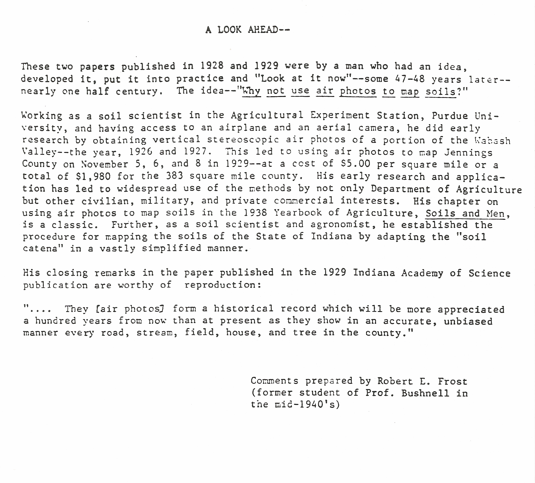
Dr. Frost began his career at Purdue University, where pioneering research in the use of aerial photography for terrain and resources analysis began in the late 1920’s. Frost worked at Purdue with both Professor Bushnell and another aerial photo analysis pioneer, Dr. Donald Belcher before moving over to the Army Corps of Engineers

During WWII the Army Corps of Engineers vastly expanded the use of aerial photography for mapping and terrain analysis. This demand was triggered by pioneering work done in the 1935 – 1941 time period by both Army topographic engineers and researchers at places like Purdue University who developed the aerial camera systems and analytical processes and tools needed to exploit this new resource
Dr. Frost noted that he expanded this work into historical terrain analysis while acting as an expert witness in a string of court cases brought against the Corps of Engineers. Starting in the 1970’s the Corps of Engineers became a favorite target of the environmental movement. The Corps was an easy mark. It was involved in billions of dollars of public works projects across the United States, most involving waterways improvements. In mid-20th century parlance ‘improvements’ mean draining wetlands, building dams and levees, dredging rivers and digging canals. A favorite joke of the day went like this: “Why don’t Corps of Engineer officers help their wives with the dinner dishes? Because they can’t stand the sight of running water!”
At some point the Corps of Engineers turned to Dr. Frost to see if he could develop evidence to prove that Corps projects were not responsible for the impacts the plaintiffs were seeking damages for. Dr. Frost figured the best way to approach the problem was to look at the history of the project areas as shown in successive years of aerial photography and try to determine the what was causing the issues the land owners and environmentalists were so upset about. Dr. Frost and his team at the Center for Remote Sensing went through the vast aerial photo archives of the the USGS, NOAA, the Soil Conservation Service, the Department of Agriculture, the Tennessee Valley Authority, state and local agencies, private aerial survey companies and even the Corps of Engineers’ own holdings to build a library of historical aerial photography covering various Corps’ project areas. Much of this photography went back into the 1930’s and predated by decades the projects that were in dispute.
Dr. Frost’s team then applied the aerial photo analysis techniques developed over decades of research and field study to establish a terrain analysis ‘timeline’ of the changes that took place over the project areas. More often than not Dr. Frost and his team were able to prove that the Corps of Engineers’ activities were not the proximate cause of the issue. Things like historical land use changes, flood and drought cycles, poor erosion control, poor land management practices or other human or environmental impacts that had nothing to do with the Corps’ activities were frequently identified as the root cause of the problem.

OK, who’s gonna’ pay?
In the late 1970’s the Army recognized the growing demand for terrain analysis products needed to support military planning and operations. The decision was made to establish Engineer terrain analysis teams at the division, corps and echelons above corps levels. The analysis processes the Soldiers in these units used were based on techniques developed by ETL’s Terrain Analysis Center. Dr. Frost and the Center for Remote Sensing were key resources the Terrain Analysis Center turned to for help developing the aerial photo analysis techniques that needed to be taught to the hundreds of enlisted analysts and warrant officer candidates that would make up these new terrain analysis teams.

Germany 1985. Soldiers of the 517th Engineer Detachment (Terrain Analysis) use a zoom transfer scope (ZTS) to create terrain overlays using aerial photography. The study was done to support the V Corps REFORGER 85 exercise. The overlay will depict soil types that are least able to support off-road vehicle traffic. The techniques used to analyze the imagery were developed by Dr. Frost and his team at the ETL Center for Remote Sensing and the ETL Terrain Analysis Center. CW2 Tim Butler, the detachment’s terrain analysis technician and an early graduate of the Frost Course, is at the ZTS

The resulting analysis for REFORGER 85 was used daily to predict areas at high risk for maneuver damage based on soil type, moisture content and ground temperature. After the exercise V Corps announced that this analysis saved an estimated $1 million dollars in maneuver damage claims compared to previous REFORGERs
At some point Dr. Frost decided to package his experience and analysis techniques as a formal class, and the Frost Course was born. This course took the elementary photo analysis processes taught in the terrain analysis classes at the Defense Mapping School and expanded them to cover a wide range of topics beyond military applications, adding course content in geology, soils science, forestry, agriculture, hydrology, transportation and urban analysis. Woven into the course were college-level requirements in analysis, research and thesis defense. It was a master class in aerial photo analysis for topographic and terrain analysis.

Dr. Frost’s ‘Statement of Principles’ for the Frost Course
Starting in the early 1980s Dr. Frost taught his class regularly at the Defense Mapping School (DMS) at Fort Belvoir, VA. Unlike so much US Army military training at the time the Frost Course was actually challenging; Dr. Frost forced you to analyze and think. There were no multiple choice questions in his course. You discussed a particular terrain issue, reviewed applicable analytical techniques, were presented with a problem, sent off to do the analysis and then came back to present your results and defend your conclusions. While you couldn’t actually fail the Frost Course, the competition to get into the class was so tough that only highly motivated Soldiers attended, so the quality of the output – skilled terrain and topographic analysts – was quite high.
The Frost Course was taught in modules (called ‘Problems’), with each module teaching a particular analytical process based on things like landform, pattern, hydrological, transportation or urban analysis. Each module consisted of some instructional material, references, an assignment sheet and a set of stereo aerial photos.

Frost Course Problem 3, Pattern Recognition

Problem 3 required detailed analysis of a stereo triplet to determine the landforms, drainage, vegetation, cultural and land use patterns. These are current photos taken of the coursework I completed in 1995.
The joke was that when you showed up for the Frost Course you got issued two things – a pocket stereoscope and large bottle of Tylenol. That’s because you spent 6 hours each day in class staring at stereo photos and then you went home and spent another couple of hours peering through the stereoscope as you worked on your homework assignment. Headaches due to eye strain were the norm.
Frost Course, Day 1 – eyestrain is starting to set in…
I met Dr. Frost back in 1982 when he visited us at Fort Bragg. The Engineer Topographic Laboratories (ETL) sent him to pitch the idea of having him teach his class at Fort Bragg. The Army had a growing demand for terrain analysts and DMS couldn’t train them fast enough. The idea was that the Frost Course would enhance the skills of the terrain analysts already assigned to Fort Bragg, provide a good foundation of skills for those Engineer Soldiers interested in becoming terrain analysts and provide additional training to a number of photo interpretation analysts from the Intelligence units on Fort Bragg. It was far cheaper to bring Dr. Frost to the students than it was to send the students to Dr. Frost. Sadly, the senior Engineer commanders on Fort Bragg disagreed and the idea was nixed. The XVIII Airborne Corps Assistant Corps Engineer at the time commented, “Why should we pay for training these guys (terrain analysts) already get when they go to DMS?” Obviously this idiot wasn’t listening when Dr. Frost clearly and concisely laid out the differences between what our terrain analysts learned in their basic classes at DMS and what his course provided.
Over the next decade I sent dozens of Soldiers from my units to the Frost Course at DMS. While many of my battalion and brigade commanders questioned the value of the course I knew that the Soldiers would come back better analysts. Being selected to attend was viewed as recognition that a Soldier was ‘on his (or her) way’; headed for greater rank and responsibility. I even used attendance at the Frost Course as a reenlistment incentive – “Pssst – hey Specialist Jones, sigh up for another three years and I’ll get you a seat in the next class.” It was surprising the number of Soldiers who took the offer.
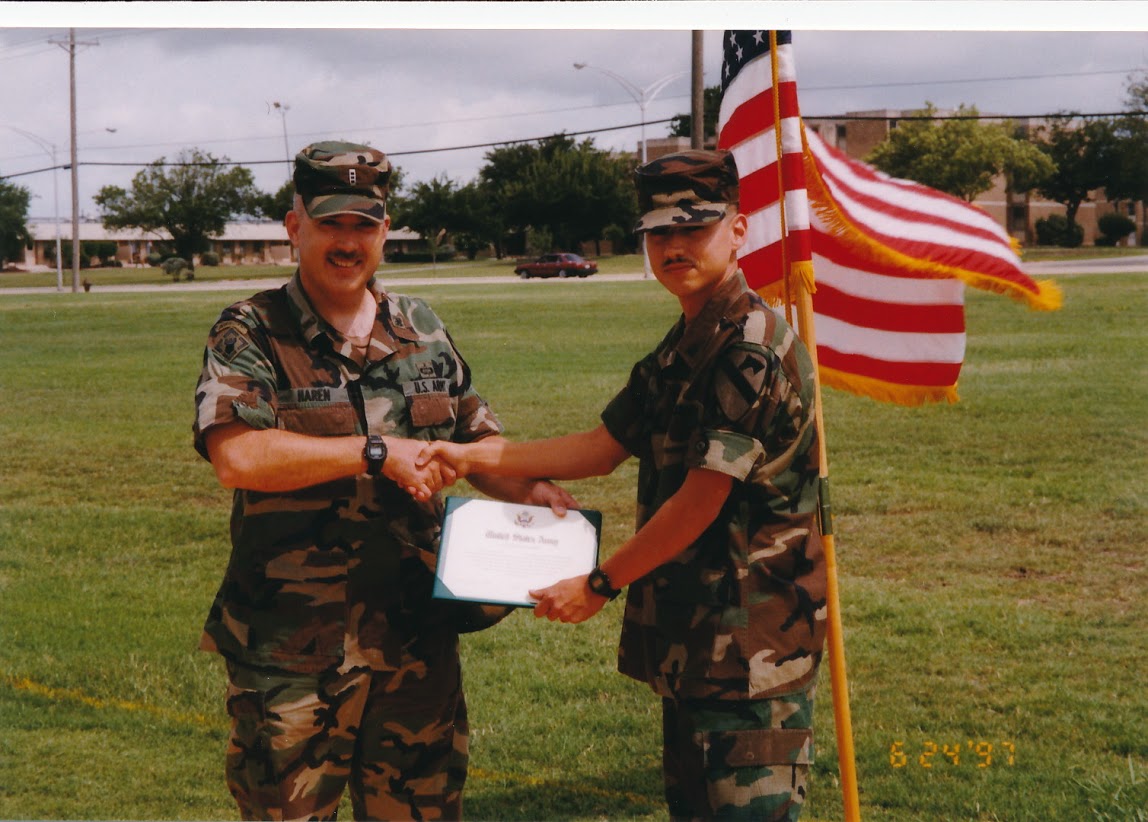
Another Soldier, SPC Cantu, reenlists for the Frost Course. In this case I was even able to wrangle him an assignment to the Topographic Engineering Center. He still owes me a beer
But I never got to take the course from Dr. Frost. I would send Soldiers at the drop of a hat but my superiors never seemed to think it important that I attend. Dr. Frost retired in 1990 but before he left he handed responsibility for teaching and updating the class over to Major John Jens, who worked at the Topographic Engineering Center (the successor to ETL) at Fort Belvoir. In 1995 I was sent to the Defense Mapping School for my Warrant Officer Advanced Course. Since only two of us showed up for the Advanced Course that year the course coordinator had little for us to do. We were supposed to work on a nebulous ‘research paper’ but that was it. I could have wandered the hallways and counted floor tiles for a month and still graduated at the top of my class. One day right after I arrived I picked up a DMS course catalog and saw that John Jens (now retired) was scheduled to teach the Frost Course the next week. I looked over at the course coordinator and said, “I’ve never been through the Frost Course. I think I’ll sit in on it.” “Sure,” he replied “sounds like a good idea.” He went back to his Washington Post crossword puzzle relieved that he wouldn’t have to babysit me for another few weeks.
A month ago I was going through some old Army paperwork and unearthed all of the Frost Course modules I worked on in John Jens’ class back in 1995. Looking through the aerial photos and study papers triggered a wave of nostalgia and caused me to write this post. But more to the point, since 1995 I’ve had literally hundreds of hours of additional education and training in terrain analysis, geospatial analysis, graduate level work in geography, geodesy and surveying and a broad range of industry specific geospatial software training. I can honestly say that nothing I’ve been taught since 1995 has approached the analytical rigor that the Frost Course demanded. It was (and hopefully still is) that good.
– Brian

Robert Frost was my dad. I am in tears reading this. I am so glad I stumbled upon this. Thank you all for you kind words. Andrea is my niece and so good to see her on here.
Should have posted my thoughts long ago. Here are only a couple – the instructor training class when i signed into DMS in June 1982 taught me a lot, mostly graphics with a dull delivery – they tried to make it exciting. but then in Dec 1982, coming off an MTT to the 1203rd in Dothan, AL, it was “suggested” i take this course on air photo analysis… it is an understatement to say that my professional life took another sudden but invigorating as well as exciting direction. “Doc” Frost gave me another newer way to look at things, a new spin on the tired phrase “terrain analysis.” Within two assignments, two civil engineers taught this professional geologist more about geology than most all my previous course work combined! It was the method as stated in the principles in this article that made the difference. And i took that into all the training i have given since regardless of what it was. It is a science of observation complemented with creating reasoning, all based on those four principles. Although we called him “Doc,” he never completed a dissertation to get the PhD. He did complete the course work for Civil Engineer (doctorate level work but without the dissertation), C.E., which he carried after his name. When i asked him once about that and why he never corrected anyone who called him “Doc” or doctor, he said it really didn’t matter, it wasn’t that important. From his count when he retired he had taught 86 iterations of the “short course” as most of the earlier folks and those at ETL called it. on my own i taught another 13 iterations under the “Frost Course” moniker for 99 total, before the plug was pulled on it from ETL (then TEC) purview. but as you have said in some of the previous comments that others have continued it – FANTASTIC! For those of you who like acronyms, a boss once told me i couldn’t call it that since Frost was retired. my retort to him was, it is the Feature Reconnaissance On Stereo Triplets Course …. yes, i still have all the materials, and even a few boxes of former students work – maybe yours!!
it was a privilege to have known him and been a student of his, and more so that he “let” me teach his course.
In his honor:
Bob Frost taught an airphoto course.
To define materials fine and coarse
Patterns made us think
And the time we’d sink
Would cause on his death our remorse.
25 Feb 2002
bob frost a short course taught
we wrung our hands as we thought
but no much how we tried
our overlays he’d deride
i’d hate to see what the long course bought
27 Feb 2002
those who knew him could understand the addiction
stereo-triplets and pattern element affliction
drainage, landforms, lineations and dotting trees
simplify, describe what you see, if you please
those funny glasses will yet be our undoing
monstrous floods you say, my logic is ungluing
from the frozen arctic to dry alluvial fan
canals across indiana, rio chama and anastasi man
warped basins in the panamanian jungle
but with the simplests tasks he’d seem to bungle
fix an airplane, floating on the arctic ocean
the tool bag went in the drink with laughing emotion
striving to explain how to form a pingo
at home in puerto rico – he was raised on the lingo
from a box of screws without any threads
the frustrations he endured would cause us dreads
poorly appreciated and inadequately understood
he sited the DEW line for our country’s good
no matter the project or it’s unfunded cost
he will forever remain to us our Perma Frost.
in loving kindness, and appreciation to my mentor & friend Bob.
1500 27 Feb 2002
I also am a “graduate” of one of the later Frost courses. Incredible experience and I think we should all have survivor t-shirts.
I agree!
Hi John,
I remember your name….. My dad was Robert….. Hope you are well
The Frost Course was taught, in abbreviated form by former students, to the Canadian Forces in the 2000s. I remember meandering trails in some images, and commenting that they looking like cattle paths I’d seen in fields on the Prairies. Turns out they were original buffalo trails on really old images. I wouldn’t be surprised if the slides, lesson plans and marking guides aren’t still held at Mapping and Charting Establishment in Ottawa.
Doctor Frost wad a very awesome person. Andrea I had the privilege to attend your grandfather’s course three times. The first time was when I was selected to attend Basic Non-Comissioned Officer Course. I was stationed at Fort Lewis Washington with Captain Herrin before he became a warrant officer. It was in 1988 and I was recalled by my unit but not before I took your grandfather’s course. It was a course I never forgot. I attend his course for a second time when he came to our unit and trained us. I attended BNOC for a second time in 1990 and was able to attend his course for a third time. This time I wrote a poem for him concerning the course. It was call “Frost Eyes”. Your grandfather and I became great friends. We stayed in touch until 2001. He was a strong mentor to me. His techniques I used in Kuwait in January 2003 in prep for Operation Iraqi Freedom. The Fort Stewart Topographic team I was the NCOIC of had to change our travel route prior to the start of the war. We gad to find a route through the desert from Kuwait to Baghdad and stay west of all major cities. Doctor Frost’s techniques I was taught helped in analyzing soils, drainage, and surface configuration features which helped in finding a speedy route and helped 3ID be able to travel 740 kilometers in 3 days. I continue your grandfather for the knowledge he gave me because it helped 3ID fight and win the OIF war in 2003. Your grandfather left a great impression on me and his expertise man me a great Geospatial Topographic Engineer. I ran the article that Brian published and it brought back great memories. Your grandfather changed my life for the better. He was a great man and mentor.
Jay
Hi Jay, thank you for sharing. I would love to read your “Frost Eyes” poem. Do you still have it? I wish he was here today so we could talk about all these great stories from the past. He had the best sense of humor and I have always wondered if he brought that to his students, or if you all only saw his more serious side! It is beautiful to hear that his work was so far reaching. Gives me great sense of purpose in life, on his behalf and because he instilled in me a desire to give back to my community.
Thanks to all of you for your service.
– Andrea
Andrea, my name is Charles Southers from Jackson, KY. I am the other soldier working with CW2 Butler in the photo in the article about your grandfather . Brian is correct it was considered a great honor to be selected to attend your grandfathers very interesting course. I will never forget him. He was a true expert in aerial photo analysis. He taught us how to identify soil types using stereo aerial photography. I loved the part he taught us about using historical aerial photography to spot changes in an area over many years. He was the best. I still have my diploma from his class locked away in a safe deposit box. His class was called, Interdisciplinary Image Analysis for Military and Civilian Purposes. You can find me on Facebook.
Charles, thank you so much for sharing your story. It must have indeed been special if you still have the Frost Course diploma all these years later! Geography certainly can be a great teacher. I am now doing image analysis with computers, so it’s pretty cool to see my work in some way tie back to his.
Oh my gosh, I can’t believe it! This article is about my grandpa!! I was talking with my mom about grandpa’s time at Purdue and a quick Google search brought up this article. Thank you so much for honoring his work, which he poured his heart and soul into. Very cool to hear that he left an impact still sitting with people all these years later.
– Andrea Frost
Andrea, thanks for your kind words. Yes, your grandfather left quite an impact on many Soldiers who served in the Topographic and Terrain Analysis fields, but it was a very positive impact. I’m glad you found this site and if you or your mother have any information or remembrances you’d like to share please let me know.
– Brian
Back when I ran the Corps of Engineers’ Ohio River Division Lab, a friend of mine from Buffalo District, whom I had worked with back during the late 1960s Niagara Falls study, talked me into signing up for Bob Frost’s course scheduled for spring of 1983 in Huntsville. Toughest 14 days I ever spent on aerial photography. The only thing that saved me was that I had already had a class in aerial photo interpretation from one of my geology professors who had spent WWII in England doing it every day for four years. Bob Frost was assisted by Vern Anderson back then and Vern was a great geologist so I really enjoyed the course. I’ll always remember the great photos Bob had of thescablands developed as a result of the glacial Lake Missoula floods. Great guy! Great course!
Wow, a slice of history! The Frost Course was one of the most intense things I’ve ever done!