

Yesterday I was poking around eBay looking for things I just can’t live without when I stumbled on an auction that caught my eye. One of my canned eBay search criteria – ‘aerial mapping’ – triggered a hit for an auction for a US Air Force publication on something called Project Casey Jones. The subtitle was the real attention getter: ‘Post-Hostilities Aerial Mapping; Iceland, Europe, North Africa, June 1945 – December 1946′. I was intrigued but the eBay seller was asking far (far) too much for the document. But since this was an official USAF publication I figured there was a good chance it was already available on-line in digital format. A quick Google search turned up a the document in PDF format on an on-line library and I grabbed a copy.
As I started to read the report it dawned on me that I never really knew where the base mapping imagery came from that allowed the Army Map Service to re-map all of western Europe and North Africa quickly and accurately right after the close of WWII. I just assumed the aerial photo missions were done on a piecemeal as-needed basis by US assets or we collaborated with host countries like France or Italy to obtain civilian aerial photo coverage.
As it turns out the collection of aerial mapping imagery at the close of WWII was a far more centralized and directed effort than I could have imagined. The fact that the project was carried out so quickly, comprehensively and effectively is remarkable and is one of the great untold stories in the US Army’s topographic history.
In 1944 it was clear to senior Allied leadership that Germany’s days were numbered and thinking started to turn to projects that would help secure the US position in post-war Europe. A huge issue that had emerged from both the ground and air campaigns in Europe was the lack of accurate and up-to-date maps and air charts. During the war the Allies’ mapping services, like the US Army Map Service, scrambled to meet the demand for large and medium scale maps. They often relied on outdated local maps of dubious accuracy, supplemented where possible by photo mosaics or photomaps based on aerial photography taken by reconnaissance aircraft. The science of mapping using stereo aerial mapping photography was well understood at the time, and the US Army Air Force (USAAF) had the necessary cameras and aircraft at their disposal, but flying long, slow and precise flight lines over enemy held territory was out of the question while both sides were still shooting at each other.
Allied military leadership realized that once the shooting stopped there would be a very short window of opportunity during which they would be able to fly photomapping coverage of most of western Europe. The idea was to get the job done while the American’s still had the political clout and the resources in Europe. The US Government and the USAAF applied a carrot and stick approach to the problem. In concert with the British Royal Air Force, the USAAF would fly the conquered territories (Germany, Austria, Italy, etc.) at will (“we won, you lost, tough luck”), and the Allied, newly liberated or neutral nations (France, Spain, Switzerland, Netherlands, Belgium, etc.) would be offered a copy of all aerial imagery collected over their territories (“we’re your friends and we’re just helping you get back on your feet”). In the end it worked, and over two million square miles of new stereo aerial imagery was collected in about 18 months.

The Project Casey Jones report brings to light some very interesting historical tidbits. The first were the technical issues. How do you keep a big, heavy bomber like a B-17 on a straight, steady course for hundreds of miles? The answer turned out to be ingenious. After the pilots failed multiple early attempts to keep the aircraft flying straight and level the job was turned over to the bombadiers and their Norden bomb sights. Since the Norden bomb sight effectively took control of the aircraft once the bombing run to the release point was initiated – controlling aircraft attitude, direction of flight and compensating for wind drift and other factors – it became a relatively simple matter to re-program the sight so that visual check points along the photographic flight line became the ‘release points’, and the bombardier actually controlled the flight by flying from check point to check point along the flightline path using the Norden. Simple but effective.
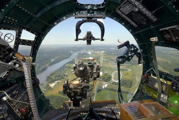
Norden bomb sight in the nose of a B-17. From this station the bombardier took control of the aircraft and flew from check point to check point along the flightline. Many of the flightlines were 200 or more miles long
The other interesting factor was quality control. The USAAF was flying to meet US Army Corps of Engineer (Army Map Service) requirements and had to adhere to mapping imagery standards for image overlap, side lap, aircraft attitude, cloud cover, haze and other factors. In the beginning the rejection rate of aerial imagery was unacceptably high – some flight crews only hitting the mark 20% of the time. Part of the problem was a lack of familiarity with the mission, part was mechanical problems with the installation of the mapping camera systems, and part was weather and atmospheric conditions. To help solve the problems and improve the success rate for the photo missions the Corps of Engineers put photomapping officers and technicians in each of the squadrons. These personnel would grab the film as soon as the aircraft landed, develop it and quickly review it while the flight crews were still in the area. They could do a quick post mortem on the success or failure of the flight and provide the crews with valuable feedback on what was needed on upcoming missions. As air crew experience increased the success rate increased, and towards the end of 1946 the success rates for each mission hovered around 60%.
Other factors worked against the project; weather during one of the worst winters in modern memory (1945 – 46), high personnel turn-over rates caused by rapid demobilization and political issues that delayed or canceled overflight permission. But in the end the USAAF was successful, and Project Casey Jones was effectively complete by September 1946.
So what became of the two million square miles of mapping photography flown during Project Casey Jones? It was immediately transferred to the the Army Map Service and was used as a primary cartographic data source for at least the next 20 years. It was used in the wide-scale production of up-to-date tactical and operational scale maps of western Europe by American and British military mapping agencies, maps that supported the operational backbone of NATO well into the 1960’s and perhaps beyond.
Brian

Pingback: Prologue – Analog to Digital
Pingback: Prologue – Analog to Digital
The aerial photos are for Casey Jones, after spending decades with the AMS were transferred to the National Archives, currently located in College Park, Maryland. The photos are available for research. They are also currently in the process of being digitized in a very long term project. Any questions, contact the Cartographic unit at the National Archives at: Carto@nara.gov
For access to what has been digitized so far, contact the National Collection of Aerial Photography (NCAP), the agency digitizing NARA’s aerial photographic collection. Their website is: https://ncap.org.uk/
Tom, great information. Thanks!
Photos of Switzerland made in this project have been released by Swiss government.
https://www.geo.admin.ch/en/home.detail.news.html/geo-internet/2019/datasetoftheweek20190521.html
My father, Kenneth Westman was a Flight Engineer stationed at Lechfeld in 1946 and also participated in Casey Jones flights over Europe and North Africa. His crew flew B17G tail numbers 48775 and 48580 “Miss Maureen”.
He wrote many letters home and also took many photos which have been preserved. I have been combining these in to a book. When one of the letters mentioned Casey Jones I asked him about it (he is still alive at 92). I also looked-up and read Robert Boyd’s “Casey Jones Project” which is an excellent in-depth document detailing this little known post WWII operation. In another letter dated 07 June 1946 he also mentions Swiss officers arriving at Lechfeld in connection to the photo mapping flights.
Also. while in Rabat, Morocco in October of 1946; on the back of one of the many photos that he took, he listed crew he was with: Lt. Helms, Lt. McElroy, Lt. Cushing, Sgt. Wiley, Sgt. Steiner. I wonder if this isn’t the same Bob Cushing mentioned in an earlier post?
Mr. Westman,
Sir, read your account about your father being in Lechfeld in connection to the photo mapping flights. My father was a flight engineer that had been part of the 422bs of the 305bg that was transferred over to also be part of this Casey Jones project.
Would you mind asking him if he recalls a Tech Sargent, Flight Eng. George Beck from that time.
He was from Iowa.
My father also told me some of the stories of what has been written down. Flights over Europe, North Africa. Two times the aircraft he was on went down because of running out of fuel.
One time bailed out over the Med., 2nd time they were too low and ditched. Said he would not recommend either one.
He also told me that at Lechfeld, after the project was complete for their part, they taxied the B-17s down to the end of the field and set charges and blew the complete tail sections off these very nice and relatively new aircraft. Quite a few of them.
I am more than pleased to correspond with you about this.
Thank you in advance for your time and cooperation in a common goal.
Also, please thanks to your father for his courage in a very bad time in world history.
Michael D. Beck
Yes, that Lt Cushing is very likely my Dad, Robert (Bob) Cushing. Though he can’t remember names of the crew, he does remember being at that USN naval air station near Rabat for a week during the Casey Jones project while photographing the West coast of Morocco. He says that on days too cloudy to proceed with their work, they would check out rifles from the base and go hunting nearby. Probably the only entertainment available nearby!
His crew also flew out of Gibraltar where they were well treated by their British hosts.
The B17G was apparently the latest version of the B17. He says it was a dream to fly after struggling to keep a B24 aloft during the previous part of his career.
Thanks for your reply which helps illuminate a fascinating slice of our shared history!
Hello Mr. Cushing & Beck,
If you would send me an email address to contact you directly, I could share some of the many photos that that my dad took while at Lechfeld and during Casey Jones flights. I will also ask my dad if he recalls George Beck.
Regards,
Kevin Westman
Kevin.westman@gmail.com
Mr. Westman, my email address is, mikedbeck12@gmail.com
Thank you for sending what you can when you can.
Michael D. Beck
Michael, would you also be willing to share them to a wider audience? I am happy to post and host any photos you would like to share here on the website.
Brian
Brian, Yes of course. Let me put together over the weekend what my father told about the project and the other points that are coming back to me when reading about the experiences of others.
Michael
Michael,
Thank you! You can reach me directly at brian.haren@gmail.com
Brian
Mr. Westman, I am actually giving a speech here in Switzerland on Casey Jones on 21 May 2019. Would your father be available for questions? I am the senior US Dept of Defense official in country.
Hi. I think all this interests me a lot. Could someone of you take me to find the photos of the Casey-Jones of Canary Islands, (spain) photos that were difficult because of the clouds? Fue la zona 25a , Thanks for your attention.
“So what became of the two million square miles of mapping photography flown during Project Casey Jones? It was immediately transferred to the the Army Map Service and was used as a primary cartographic data source for at least the next 20 years. It was used in the wide-scale production of up-to-date tactical and operational scale maps of western Europe by American and British military mapping agencies, maps that supported the operational backbone of NATO well into the 1960’s and perhaps beyond.”
And later ended up at the National Archives (NARA #A2 Building) in College Park, Maryland. Currently, this aerial photography is being digitized on a long term project by the National Collection of Aerial Photography, headquartered in Edinburgh, Scotland, UK. As of right now, the main collection available as digitized aerial photos are captured German photos of Russia. Some of the aerials are already online and available for purchase here:
https://ncap.org.uk/news/first-batch-nara-images-released
Dad was in the 306BG during the war. He flew Tower of London ( http://www.americanairmuseum.com/aircraft/17329 ) on Casey Jones, worked his way south into Africa. Got to visit the pyramids. Almost did not make it, took a bird strike in the nose. A couple of feet higher it would have come right through his windscreen!
My Dad, Robert “Bob” Cushing was an aircraft commander, 21 year old 2nd Lieutenant of one of those B-17s out of Lechfeld. One day they had been assigned to revisit an area in Switzerland due to “holes” in the photographic record caused by clouds. He relates this incident which “Scared the living Hell out of me”, paraphrased as follows.
“We flew the runs at 18,000ft so had to wear lots of clothing and use oxygen. After we had finished our assignment the crew chief suggested that we drop down to 10,000ft so we could take off our oxygen masks and get a better view of the beautiful Swiss countryside. ‘That’s a good idea’ I said. We did so, and as we were flying back to base, suddenly 2 Swiss Air Force Messerschmitts fly up from underneath my B-17 and positioned themselves on each of my wing-tips. I thought they were gonna shoot me down! But instead the pilots saluted me, escorted me to the German border, wiggled their wings and peeled off. I found out later we were only allowed to fly at 18,000ft!”
” The next day a Swiss Air Force Major arrived at Lechfeld in his Messerschmitt, and I thought I was gonna be court-martialed! Fortunately, he was there to see how the project was going. However, when he challenged our Colonel to a ‘dog fight’ in our p-47, he put us to shame!”
My Father is still alive and he worked on this project. He was a photographer on the project. I was asking him yesterday about it so decided to look it up. I can’t wait to share this with him
Could you please ask your father if might remember aTSg Géorge Beck with 422bsq? Also did he remember any of the aircraft ditĉhing or running out of fuel? Thank you very much. MD “Doc” Beck.
Love your posts, Brian. I’m retired NGA (former NIMA, DMA, AMS).
I’m working on a project for the NGA history office and am focusing on those who lost their lives in support of the IAGS mission. So far, I’ve identified:
Richard Lucas, 1952, Chile
Donald Newbury, 1952, Chile
Raymond Johns, 1979, Chile
Captain Orrin Duel, 1960, Bolivia
Captain Hugh Broyles, 1960, Bolivia
Sp4 Joseph Karson, 1960, Bolivia
Dick Hayward, unknown date, reportedly Bolivia
T-Sargent Joseph Wegener, 1948, Venezuela (air crash on supply mission, but may not have been IAGS)
There is also reporting of a C-47 crash on 1 Feb, 1950 in Guatemala and another
C-47 crash on 17 Aug, 1950 in Costa Rica. No names were reported.
I’m looking to identify others, or more information on the accidents that took these mens lives
Just ran across your site for the Casey Jones project. Wow. I was a camera man assigned to this
project. We worked out of four of the sites shown on your map. Brought back memories.
Norman, thanks for the comment. We’d love to hear some of your stories regarding Project Casey Jones!
Brian
I noticed that the photo of the bombardier’s station in the B-17’s nose appears to be from the Yankee Air Force’s “Yankee Lady”. I rode in that airplane a few years back and your photo looks as if it could have been taken on the very same day – every detail in the photo is the same as in mine. https://www.flickr.com/photos/widdgget/14504439469/
Back when we had highly innovative, intelligent people in charge.
The solution to the problem of the high photographic rejection rate evolved into the TIIF – tactical imagery interpretation facility – a major component of the Army’s OV-1 Mohawk aerial surveillance companies. Housed in an expanding van at the supporting airfield, the imagery interpreters immediately developed the recently downloaded camera film and reviewed the accuracy of target or area coverage, and produced intelligence reports on the spot.