It is Memorial Day and I’m thinking about those that made the ultimate sacrifice, and what might have been done differently that could have ensured many of those we lost instead made it home safe and sound.
One of the key Engineer topographic intelligence failures of WWII took place during the planning phases of Operation Overlord, the Allied invasion of France. This was the failure to properly assess the impact the hedgerows in Normandy would have on our ground movement and tactical operations. This failure to identify and assess the impact of the hedgerows, and then develop tactics and training procedures to deal with them, resulted in the unnecessary deaths of hundreds of Allied Soldiers.
The hedgerows in Normandy were used to create small pastures and farm fields, many of them just a few acres in size. In a land without rocks or trees these hedgerows were the fences that kept cattle from wandering off and allowed farmers to clearly identify what land they owned.
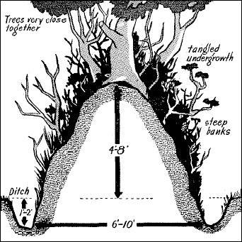
The Normandy hedgerows were made up of linear mounds or walls of earth topped by a thick tangle of trees and brush. Most of the hedgerows dated back hundreds of years, some back to the time of William the Conqueror. Centuries of soil compaction and vegetation growth meant the hedgerows were dense, sturdy obstacles that were virtually impossible to penetrate. On a flat and otherwise featureless coastal plain the hedgerows created heavily dissected terrain with limited line of sight and restricted virtually all off-road movement.
The hedgerows of Normandy, just in from Omaha Beach, created a tactical nightmare for the US forces that landed there on June 6th, 1944
Hedgerows in Normandy as seen in an oblique aerial reconnaissance photo taken by the US Army Air Force before the invasion. In this photo the hedgerows present obvious obstacles to movement so why didn’t they get more serious analysis?
The German Army was the master of the defensive operation. We had already seen that in Italy, where German Field Marshall Albert Kesselring established a defensive line in the mountains north of Rome (known as the Gustav Line) that turned Churchill’s ‘soft underbelly’ operation into a meatgrinder that chewed up entire Allied divisions. In Normandy the local German commanders had months to study the problem and turned the hedgerow complexes into deathtraps. Every hedgerow corner, every road and trail, every chokepoint was covered by machinegun, mortar, anti-tank and artillery fire. Normandy was a defender’s paradise, and the Germans made the most of what they had. Normandy became a textbook case of a tactical defense in-depth, and the German efforts are still studied today.
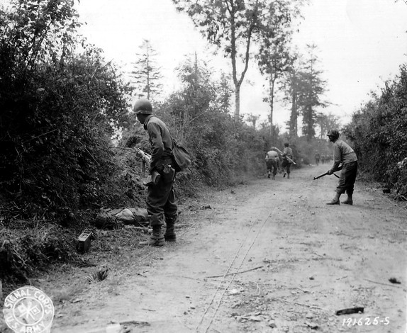
American Soldiers cautiously working along the hedgerows in Normandy to flush out German defenders
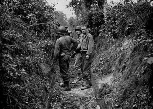
American Soldiers standing in a narrow lane between two hedgerows somewhere in Normandy. This type of terrain became an alleyway of death for Allied Soldiers who only had two options – advance directly into the enemy fire or retreat back from it. There was no going around
The Allied armies never really defeated the hedgerow problem. The advance through Normandy became a slow slog with infantrymen fighting for every foot of terrain. The US Army eventually developed a set of combined arms tactics using dismounted infantry and tanks that allowed effective movement, but in the end it was commanders like General Patton who simply decided to punch through the hedgerow country and break out into the more open terrain south of Paris. In the end the Allies simply bypassed the German defenders in the hedgerows and left them to wither on the vine. Most surrendered within a few weeks, out of food, out of ammunition and out of the will to continue the fight.
But the question remains – how did we miss the impact the hedgerows would have on our tactical operations? We didn’t lack for topographic intelligence analysis during the planning phases for Overlord. The beaches and inland areas of Normandy received some of the most intensive Engineer terrain and intelligence analysis ever applied to a piece of ground. We collected tens of thousands of aerial photos (many of them in stereo), built hundreds of terrain models and printed thousands of special maps and geographic (terrain) studies of the Normandy region. Small unit commanders had the best picture of their objectives, and the terrain leading up to their objectives, than had ever been developed for any military operation up to that time – and yet we missed the hedgerows!
There’s no definitive answer in the historical record as to why the Normandy hedgerows were not identified as significant obstacles, but I can make a few good educated guesses as to what happened.
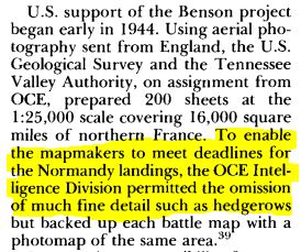
First, there is this intriguing passage from Chapter 13, Looking Ahead To The Continent from the volume ‘The Corps of Engineers: The War Against Germany’, part of the US Army’s official history of WWII (the excellent ‘Green Book’ series):
The large scale topographic map is the standard military planning document. Planners at all levels – from Infantry platoon all the way up to Theater Army G-3 – rely on the topographic map to provide an accurate representation of the ground they are going to fight over. The general assumption is that if it’s not on the map it is either not there on the ground, or it’s not important enough to worry about from a military operations perspective. Yes, the map is just a base to build on, but Soldiers are trained from day one to trust what they see on the map to be an accurate representation of what they will find on the ground. If hedgerows are missing from the map, even though they may be visible in aerial photography, the assumption is that someone further up the chain with more smarts and access to better data took a hard look at the hedgerow problem and decided it wasn’t anything to worry about. This seems to have generated a false sense of security regarding the hedgerow issue that permeated all levels of Allied command.
Additionally, in the same chapter Major General Cecil Moore, the Chief Engineer of the European Theater of Operations, admitted that his Engineer staff was inadequate to the task of providing all the topographic intelligence needed to support the invasion planning. Topographic intelligence was new ground to many Engineer officers and they lacked the education, training and experience necessary to provide the support needed. This is a remarkable admission considering all the other excellent Engineer analysis that took place prior to the invasion. My guess is that Moore’s staff focused tightly on analysis of the invasion beaches, exits from the beaches and the avenues of approach to the initial objectives, and German obstacle emplacements that were visible in aerial photos. There were river crossing operations, road repairs and improvements, airfield construction, port repairs and a whole host of other critical Engineer tasks to focus on. Hedgerows, if anyone on Moore’s staff thought about them at all, were probably considered a minor issue in the overall scheme of things.
There are three other issues that I’m sure probably came into play – wishful thinking, complacency and ‘go fever’.
Wishful thinking. Having served on Army planning staffs from brigade all the way up to theater army level I can assure you that there’s a lot of wishful thinking that goes on during the staff planning process. While we train our planners to not allow wishful thinking to creep into the planning process, many times tough problems that are just ‘wished away’ on the assumption that someone else will solve it or it will resolve itself before the operation gets underway. I’ve seen this dozens of times, like when I told a tank battalion commander that his 12 foot wide Abrams tanks won’t fit down that 10 foot wide trail in North Korea that he was planning to use. He waved his hand dismissively and told me that if and when the time comes he’d find a way around the problem.
Complacency. American Soldiers had been training in England for months before the invasion, and hedgerows are a common feature of the English countryside. But the hedgerows of England are were far smaller and easier to move through or over. Most could be simply hopped over. I’m sure many unit commanders looked at the aerial photos of Normandy and based on their experiences in England didn’t think the Normandy hedgerows would be much different. After all, a hedgerow is a hedgerow, right?
‘Go fever’ is the feeling that nothing is going to be allowed to stop the show. I’m sure ‘go fever’ saturated the Allied planning staff as June 6th approached. Nobody was going to try to halt the invasion for any reason; it was going to go as scheduled regardless of any last minute issues that might pop up. When an entire Army has ‘go fever’ nothing seemingly as minor as hedgerows will stop the largest invasion in history.
It took decades for the Army Corps of Engineers to recognize that topographic intelligence analysis was a critical skill that needed formalized processes and uniquely trained Soldiers. It was actually the Army Intelligence community’s efforts in the late 1970’s to formalize the Intelligence Preparation of the Battlefield (IPB) process that spurred the Engineers to action. IPB as an analysis process is heavily dependent on weather and topographic (terrain) analysis. The Intelligence community was set to establish their own organic terrain analysis assets when the Director of the Army’s Engineer Topographic Laboratory warned the Chief of Engineers that if he didn’t get serious about Engineers doing topographic analysis a key and historic Engineer responsibility would be ceded to the Intelligence field. Soon after the Corps of Engineers established the Terrain Analysis field and seeded Terrain Analysis units across the Army division, corps and theater army force structure.
Today Terrain Analysis is known as Geospatial Analysis and it’s the last vestige of the old Army topographic field left in the Army’s force structure. Since 1980 the Army’s Terrain/Geospatial Analysts have been doing the type of detailed analysis that might just have identified the hedgerows in Normandy as a serious obstacle. Our analyst are trained specifically to look at the small stuff – the trails, the fencelines, the stands of trees, even the hedgerows that might pose a problem for even the smallest of military units.
On this Memorial Day I’m praying we never have another ‘hedgerow problem’ on any battlefield American Soldiers are deployed to.
– Brian


Hi Brian – my grandfather was seriously injured during the Normandy advance, and survived for 3 days hidden in the hedgerows. I am interested in using two of your pictures in a family history book – to be published for my extended family. Please let me know what rights are linked to these photos. thanks!
Ed, the pictures in that blog post are all in the public domain, so please feel free to use them! Glad I could help getting your book together. May I ask – what unit was your grandfather in? Was he infantry? A tanker? It’s amazing that he was able to ‘hide out’ for that long with serious wounds
Thanks, Brian. He was infantry – the 38th Regiment, 2nd Division. He was hit by an anti-tank shell near the village of La Giffardiere and was partially paralyzed for the remainder of his life.
This could be incorrect, but I had heard that the main purpose of the hedgerows was to prevent or at least slow high winds from the Atlantic and the Channel from blowing away extreme rich topsoil. I would be interested in reading any additional comments. I did enjoy the article. Thank you.
The hedgerow problem was partial solved by n innovative soldier, SGT Curtis Cullin of the 102nd Cavalry Recon Squadron, a National Guard unit from New Jersey. He came up with the idea to use the I-beam barriers at the beachhead as “teeth” on the front of tanks. The beams were cut and welded onto the front slope of the tank and basically allowed the tank to cut an opening in the hedgerow. He and two officers were awarded then Distinguished Service Cross for their efforts in supporting the breakout from the beachhead.
On somewhat of a tangent there was once a hedge of huge dimensions. It stretched 2,500 miles across India and provided the British revenue collectors a choke point to enable the collection of salt taxes and to discourage the smuggling of that commodity. The Great Hedge of India by Roy Moxham is an interesting read on the topic. If anyone is interested in how hedges are actually laid there are many videos on Youtube showing, chiefly in England, the process. If you are curious just type in hedge laying. While the hedges on the videos very rarely include the banks of the Normandy hedges the process of training the shrubs and trees is similar.