
I was going through some photos in my collection for some Facebook friends and ran across a collection of old shots I acquired while assigned to the 320th Engineer Company (Topographic) back in the late 1990s. I say ‘acquired’ because I just happened to find them lying around my office as part of some left over historical records from the old 649th Engineer Battalion (Topographic). All are 1970’s vintage photos that highlight the map making activities of the 649th. The 649th provided comprehensive topographic support – survey, map production & distribution, terrain analysis, and geographic intelligence analysis – to US Army Europe (USAREUR).
In the early 1980’s I was assigned to the 649th at Tompkins Barracks in Schwetizingen, Germany. I served as the commander of one of the terrain analysis detachments. I have a lot of good (and some not-so-good) memories of the 649th and the Soldiers that served in the unit. Fifteen years later I found myself back in Germany. By then the 649th had been deactivated and my unit, the 320th Engineer Company (Topographic), was the last surviving remnant of the 649th. The 320th had received a lot of left over equipment and paperwork from the 649th and one of my duties was to sort through it all to determine what was worth keeping and what could be trashed. During this process I found the photos you see in this post.
All of these photos were rejects, shots the photo editor didn’t think were worthy of using in a presentation. That accounts for a lot of the grease pencil ‘mark outs’ you see on many of the images. The interesting part is that the pictures that made it past the editor and into various publications or presentations are long gone – either packed up with the unit’s archives and locked away in an Army records warehouse or tossed into a trash can. Only the rejects survived to make it to my desk long after the battalion inactivated.
The 649th rarely made a new map from scratch. Most of the work involved updating existing maps or creating specialized overlays (like military operational graphics) to be overprinted onto existing maps. Still, the battalion had all the functional components necessary to create a new map:
- Topographic and geodetic survey
- Photomapping and cartography
- Layout, photolithography and printing press operations
To accomplish these tasks each topographic company within the 649th was divided into three platoons – the Survey Platoon (topographic & geodetic survey), the Photomapping Platoon (photo control, compilation and drafting) and the Reproduction Platoon (layout, photolithography and press).
So let’s take a look at these processes as practiced by Soldiers of the 649th. This isn’t intended to be a comprehensive overview of map making; there are some large gaps in this tale simply because I don’t have any photos depicting specific steps. The real goal here is to highlight the Soldiers and their activities.
Survey
Each map starts with two things – stereo aerial photography and a topographic survey to ‘tie’ the photos to their location on the face of the earth. Army topographic units relied on US Air Force photomapping squadrons to provide the aerial photography. Once the topographic unit got the aerial photography in hand it was up to the surveyors to go out and collect precise location data for points visible in the photographs – things like road intersections, prominent terrain features or pre-positioned survey point targets.

APPS – the Analytical Photogrammetric Positioning System. The APPS permitted surveyors and terrain analysts to precisely determine points on the ground using georeferenced stereo images. The system consisted of a point positioning stereoscope hooked to an early HP desktop computer. Each set of stereo images came with a computer tape that held the ephemeris data for each image. The operator would pick a point on the image in stereo (road intersection, building roof, etc.), tap a foot switch and the computer would print out the point location in latitude and longitude. The APPS was often used by surveyors to collect photo control point coordinates without having to do a formal field survey. For its time this was a revolutionary system.

Surveyors ‘turning angles’ with a conventional theodolite (probably a Wild T2). The instrument would be set up over a known control point and used to measure the precise angle to other control points. The operator would call out the angle readings and the Soldier standing behind with the notebook would record the readings and do quick checks of the angle measurements to ensure the readings were accurate.
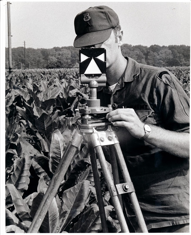
What are the surveyors in the previous photo aiming at? One of these, of course! This is a Wild survey target. It would get set up over a control point that is key to the survey. The theodolite operator adjusts the crosshairs in the theodolite telescope so they bisect the white ‘arms’ and ‘skirt’, of the target, then reads the angle of measurement.
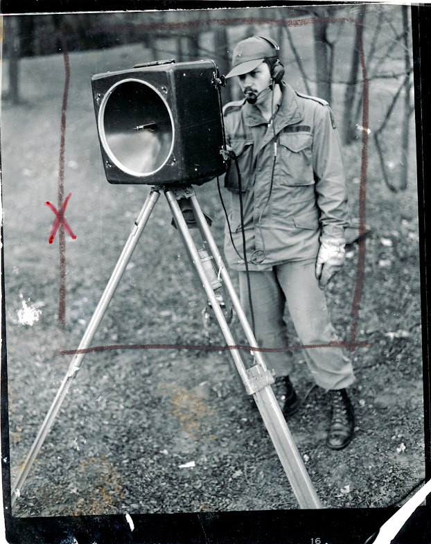
If a theodolite measures angles how do we measure distances? Well in the 1970’s we used microwave distance measuring equipment called the Tellurometer. The system consisted of a master and a remote unit and measured the time it takes a reflected microwave signal to return the master unit, which was then converted into distance. While I don’t have any hands-on experience using these units, I do remember sitting in on several meetings at the 649th where the surveyors discussed what a headache they were to operate and maintain. By 1980’s standards this was old technology and the units the Army had adopted were becoming maintenance nightmares. But in their time these distance measuring units were a revolutionary time saver. Note the headset the soldier is using. He’s actually talking to the operator at the remote unit via a built-in radio link. The two operators had to continuously coordinate settings and monitor performance during the distance measurement operation.

Here is the back of the Tellurometer unit showing the instrument settings panel.
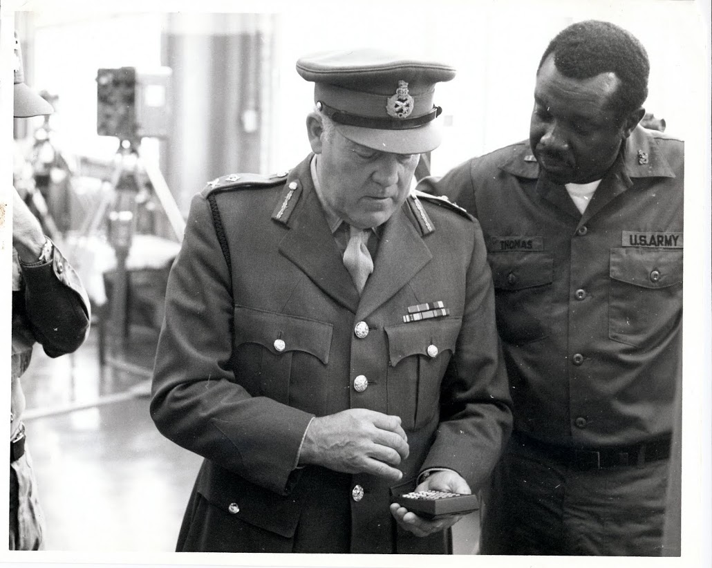
This picture shows the only Soldier in this series that I’ve met. CW2 Thomas (on the right) is demonstrating a new Hewlett-Packard calculator to a visiting British Army officer. CW2 Thomas was one of several survey warrant officers assigned to the 649th. We met at Fort Bragg, North Carolina years after this photo was taken. The Hewlett-Packard (HP) calculator is interesting because they were widely adopted by surveyors due to their rugged construction and advanced functions that were well suited to surveying applications. While I don’t think any HP pocket calculator was ever officially adopted by the Army they were in wide use at the Defense Mapping School where our surveyors were trained. Many of the HP calculators found their way into survey units through local purchase by individual units.
Photomapping
Photomapping is the process of compiling a topographic map based on information seen in the aerial photographs. Military topographic maps consisted of at least five distinct information layers, each with its own color – cultural features (black), water (blue), vegetation (green), contour lines (brown) and boundaries and built-up areas (red). It is the job of the cartographer to extract each of these information layers from the aerial photography to create a map manuscript. First the cartographers would rectify each aerial photo by removing any tip or tilt in the photo and tying it to the survey control points. Then they would use a device called a multiplex plotter to project the photos in 3D so the cartographer can trace out the key features while viewing the photos in stereo. Once the information is traced onto a manuscript sheet it is passed over to other cartographers who precisely trace out the collected information using the precise symbols we see on the finished map.

This photo shows a cartographer setting up a multiplex plotter in preparation for tracing out a new map information layer using photomapping techniques. The multiplex plotter used a stereo pair of aerial photos to project a 3-dimensional image of the terrain onto the white disc or platen of the mutiplex tracing ‘table’ (the device with the white disc seen sitting on the table). The tracing table has a small tracing dot engraved on it that sits directly above a pen holder. The stereo images have been transferred to two small glass diapositive images, and in this picture you see the cartographer holding one of the diapositives in his left hand as he mounts it into the projection stage. The tall ‘can’ in his right hand is the projector assembly that contains the projection lamp, lens assembly and filter. One diapositive is filtered red, the other blue, and the operator wears a pair of glasses with one red and one blue lens (just like the old-time 3D movie glasses), enabling him to see the projected image in stereo.

Here we see a cartographer tracing data from the projected image onto a manuscript sheet (usually a sheet of dimensionally stable material like Mylar). You can see entire image projected onto the the table surface just under his forearm, but only the small area projected onto the multiplex table platen is in focus. Engraved on the center of the platen is a small tracing ‘dot’, and mounted directly below it is a tracing pencil. The cartographer carefully adjusts the platen up or down so the tracing dot appears to rest directly on the ground on the stereo image and he then begins to trace out features. He traces one layer type onto each sheet; one sheet for cultural features, one sheet for hydrology (water), one sheet for vegetation etc.

Once a manuscript map layer is drawn it is turned over to other cartographers who carefully trace out the data using approved map symbols and line types. This is called the compilation process, where the cartographers compile the data into standard formats. Map compilation is precise and exacting work, and a cartographer can spend days, sometimes weeks, working on a single sheet.

Once each manuscript layer is complete it the information it holds is photographically ‘burned’ or transferred to specially coated plastic called either scribe coat or peel coat (seen above). The words ‘scribe’ and ‘peel’ describe the manner in which the orange coating (seen above) is removed to create clear windows through which a photographic negative can be exposed. Because of the unique nature of the orange coating it completely blocks all the light wavelengths that a film negative is sensitive to, so the orange areas come out black (or unexposed) when the negative is processed. Cartographers use specially designed scribing tools to carefully etch away the areas that represent point or linear features like individual buildings or roads. For larger areas like lakes or farm fields a sheet of peel coat is used, which allows large areas to be carefully cut with a sharp knife or razor blade and peeled away.
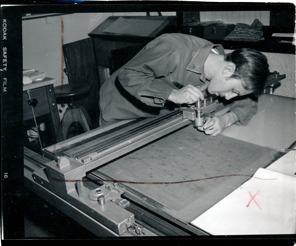
All military maps have grids, and the grid on each map is unique based on the area of the world it covers. Calculating and drawing these grids requires great precision and accuracy since the grids must be exact or the grid coordinates a Soldier derives from an improperly gridded map could be hundreds or thousands of meters off. Here a cartographer is setting up an automated plotting device used to precisely draw the grid for a particular map sheet. Automated tools like this greatly reduced the human error often encountered when drawing grids and speeded up map compilation.
Map Reproduction
Once the cartographers completed the map compilation phase the manuscript sheets were turned over to the Reproduction Platoon for all the steps necessary to print the final map. This normally involved preparing negatives from the scribe and peel coat layers prepared by the Photomapping Platoon, editing and correcting the negatives, making press plates and finally, printing the map.

To speed up the map compilation process cartographers made heavy use of pre-printed text. Things like standard place names (cities, towns, etc.), major feature names (rivers, mountains, etc.) and road identification symbols (highways, autobahns, etc.) would all be identified using standarized text that was prepared by the Reproduction Platoon. The cartographer would submit a list of feature names with text style and size requirements and the Reproduction Platoon personnel would provide the information on clear adhesive backed sheets that were created using a photo transfer process. Here we see a Soldier setting up some text as requested on the order sheet attached to the clipboard.

One of the last steps in map production is making the negatives from which the press plates are produced. Here we see a Soldier from the Reproduction Platoon doing a final check of a negative before approving it for plate production.

The final step before going to press is the plate making or ‘burning’. Press plates are just thin sheets of aluminum specifically sized to fit on a printing press. A map layer negative representing all features of the same color (black, blue, green, brown or red) is placed on top of a press plate that has been coated with a photo sensitive emulsion and the two are placed in a vacuum frame plate maker that uses a high intensity lamp to ‘burn’ or expose the positive image onto the plate. Once the plate is burned it is washed to remove the emulsion and the resulting image is what gets printed on the map. In this photo we see a Soldier from the Reproduction Platoon doing a final cleaning of a press plate before sending it on to the press section.

The 649th ran a number of presses of different size and capacity, everything from small trailer mounted presses capable of producing only 1:50,000 and 1:250,000 scale maps to large format presses permanently installed in the battalion’s base plant and capable of producing over-sized maps and other geographic products. In this picture we see a press operator from the Reproduction Platoon loading a press plate onto a van mounted Harris offset press.

Here’s a photo of one of the 649th’s presses installed in its baseplant at Tompkins Barracks in Schwetzingen.
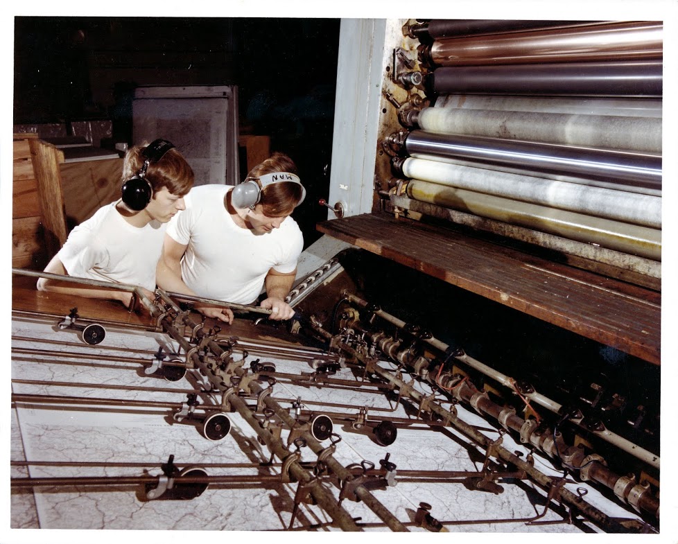
Here’s a photo of the feeder end of another one of the 649th’s large format presses. In this photo it looks like already printed map sheets are being fed back through the press to add another information layer or military overprint.

The very last step in map production is actually map distribution. The 649th also had a Map Distribution Platoon that stocked and distributed the printed maps to units all across Europe. The platoon was responsible for getting the most current maps into the hands of the front line soldier as quickly as possible. The 649th maintained a map distribution warehouse at Tompkins Barracks and at several contingency sites around Europe. The platoon even had specially designed vans that were mobile distribution warehouses that could service forward deployed headquarters. Here we see Soldiers from the Map Distribution Platoon restocking maps at the distribution warehouse at Tompkins Barracks.
And there you have it, Army field map production circa 1970. As I mentioned in the start of this post I’ve taken a lot of liberties by overly simplifying the map making process with the intent of highlighting the Soldiers and activities of the 649th. If any readers recognize any of the Soldiers shown in these photos (or if you happen to be one of these Soldiers) I’d love to hear from you. You can either add a comment to this post or contact me at oldtopographer(at)gmail.com. If I’ve made any factual errors in the map making process, or if I’ve mis-identified any of the process shown in these photos please leave a comment here and I’ll make the necessary corrections. Thanks, and I hope you’ve enjoyed this trip down memory lane!
– Brian

Aloha!
To all the “Toponeese”
I started my military career after Basic as a Topographer, 81C Graduated in spring 1971.
I had just visited the “ole” school house at Belvior this past spring (Early March 2023) and had lunch with Mr.Batt, at the Hibachi Grill along with many “Ole” Friends.
Reading these interviews of past assignments of all, brings back so many memories.
My assignments has been with all 3 Topographic Bn’s
Started with the 29th;
1971-75 at Ford Island; 1978-1985 at Shafter
1990-1995 Shafter
1997-2000 Shaftet
RETIRED: 2000
649th 1975-78
Tompkins Bks. S3 EDIT, 517th Terrain Det,
Campbell Bks at the
“H- Building”
649th
506th Terrain Det (1985-1987)
1987-1990 Tompkins Bks (many duty positions)
30th Ft. Bragg
1995-1997
During these assignments I remember meeting and working with many mentioned in your comments.
Such GREAT MEMORIES!
Just got in contact with Glenn Rick O’Neal this past months
If any of you would like to regain “Ole” friendship
my email
csm-ays@hawaii.rr.com
Mahalo,
Al Shimizu
I have a good friend name Don Kirk also a 656/649 alum from the early 70s. This man is a treasure trove of photos of Tompkins and 649. He was the editor of the news paper Topo Topics at the time. If interested I can contact him see if he is interested
It’s great to find this site and I remember a bunch of you guys now that I’ve read the comments.
I am Bill Gulley, I was transferred from HQ Heidelberg to the 656th about March ’72 and left the 649th around May ’75. Initially I was the clerk typist who couldn’t type very well and bounced around in the Bn. I worked with Al, Don and Glenn with SFC Tad, and MSG Tok, Chief Maxwell. I ended up in the 517th Terrain Intelligence Det. on the top floor of Bn. HQ. There I worked with Lt. Snead, SSG. Eddy, and names slip by me now/. I had two females in my squad and another worked in S-1 as I recall. Anyone recall SFC Akers in Repo? I don’t think he ever got caught reproducing sheets of ration cards at night and the way we went through vodka he needed them!
Remember 1SG Hester, he really didn’t like me and I went from company to company trying to stay out of trouble, then Tad, Tok and Akers took me in with Cpt. Andy Aadland as my CO.
I admit, I wasn’t a happy camper when I first got there and had my share of extra duty as a buck private. There seemed to be some friction between Hester and Akers, a bit of competition, I mention it only because Tad, Tok and Akers used me as an example of what outstanding NCO’s they could be. They turned a “Private Beatle Bailey ” into Soldier of the Month twice and of the Quarter and got him to Spec 4. (LOL)
Later on my family came over, my wife Martha got a civilian job in Repo with Judy, SP4 Atkins wife.
I re-enlisted and went to Air-Traffic-Control School at Ft. Rucker, then back to Ft. Polk where I went to the USAR and was later commissioned. Some of the best memories of my life were from Germany. It’s made my day finding this site and wishing all of you good health and great memories.
Was stationed at Tompkins with the 649th Eng Bn, 630th Eng Co. as an 81C from 85-87. Worked with some great people…Some of the names I can remember, 1st SGT Claude Heath, SPC Michael Ramos, SPC Jason LaRose, SPC Barbara Hill, SPC Penny Hammer, SPC Whipple, SPC Oaks, SSG Henry….can see alot more faces…just can’t remember the names…
I was stationed as an 83F!0 (printer) in July of 82 through July of 84 at the Fixed Plant at Tompkins. I normally worked on a Sordz double head press (Schnellpresse – Heidelberg) with a German National – Gernot Keller. I think I even recognize the old press in the mobile van (We were fixed location but had a press van when we went on maneuvers) I believe the press in the van was a Chief.
Hey Brent, I’m pretty sure I remember you. I worked with Denise Hatcher who married Bob Dierickx from Plate and Layout. I started out in Carto and landed at the end working for Cheif Maxwell in the vault at the rear of the plant where the huge paper cutters are. Did you go with us to the Heidelberg Press Factory to get training on the 4 color press? Do you remember Seargent Free, Seargent Price?
Who was the really funny press operator who was short and skinny and had that big bushy mustache that was so pushing the regs…LOL. He trained me on the operations of all the presses we had so that I could help recommend adjustments to the press when I had to pull and review quality checks working for the front office. If you like, I have our company picture online, I can share a link to it if you like.
Chuck
Sgt price retired as chief warrant officer Price
I do remember you from those years. I also remember SSG Price (Pappy) “Your boots look like bullshit!!!” I am friends with Bob Dierickx on FB. Sadly, he lost Denise this last year ( i think) to cancer. He was from Minnesota just like I am. I would love the link to your company pic. Sadly, I didn’t take too many pics while in the service. I guess I was not really a camera-savvy person. I also worked with Rodney Fortmann (Pressman) Al Janney (Camera or Plates I believe) Vince Masulitis (SP5 – Camera/ Plates) Mike Heins (SGT- Pressman) Ritchie Blackwell (Pressman on the big Harris) Richie and I worked on the big job making a full size map of Beirut after the truck bombing of the Marine barracks there. I was up for an Army Achievement Medal for that one but was denied because I was “overweight”. Yes – I and Keith Zesch were in Pappy’s Chub Club for awhile. I’m friends with most of these guys on FB. My email is bwaale@hotmail.com (for the picture link)
Best Regards,
Brent Waale
Thief River Falls, MN
I do remember the Oversized printing of the Beirut City Map, it was printed on the large one color that I think was a Miller Press, it was the one that was lowered into the fixed plant with a Helo when the plant was just starting out. We printed thru the night to get them out the door, but ours was for the Embassy Bombing, April 18, 1983, by the time the barracks was hit by 2 truck bombs on October 23 of the same year I was already back in the states.
That is correct, I remember now that he received his commission. I’m pretty sure it was before I left for the states.
I was in 656 when it ended and became 649. HHC Survey 82E. Warrant was Brown, squad leaders were Clark, Kameda, Teet, and Terry. I was in Clark’s squad with Kimmons, Kearns, Peterson, Harada, Merritt, Barnett, and one other whose name eludes me. Chief computer Cadena.
I was station at Tompkins two different times as an 83F. The first time from 6/76-6-/79 and the second time from 9/90-1/93. The photo of the man mounting the plate on the old Chief 29 printing press is of SSG Bruce Yandell who was my squad leader during my first tour. I also remember David King who was mentioned in one of the other replies. I was In B Co my first tour and operated both the Chief 29 and the new Harris L129 presses. Was one of the original press operators for the TIPS (Tactical Information Printing System) Team. SFC Ralph Gordon was my first platoon sergeant the 76-79 tour. I was in B Co. again for my second tour, also HHC before I was sent home when 649th started to draw down. I was B Co operations NCO, HHC 1SG and S2 NCOIC before I was sent to Ft. Bragg to finish out my career. I very much enjoyed both my tours with 649th and love the Heidelberg area.
I thought that was Bruce Yandal. I learned he passed away in early 2019. I wrote on his obit page and his widow contacted me with a thank you on Face Book. Bruce was my section sergeant at Bragg in HHC, 1st Psyops Bn. from Dec 80 through June 82. Was a wonderful guy and got me through a difficult time just before I PCSed to Germany and Tompkins. I also worked with that old Chief press for a short time when we went on maneuvers (82-84) Otherwise I was mostly on the Heidelberg SORDZ in the 585ths Fixed Plant.
Hello, I was 83F20 Offset Pressman at Thompkins from 1973 thru 1975. I have plenty of pressroom photos that I took in 1975, just before I rotated out. I certainly know all the names mentioned in Wade’s comment above. In fact, I kept in touch with Carl Abt for over 30 years! I can add photos if anybody is interested… Great review of what we all did. I had a blast in my 2.5 years in West Germany!
Please do post pics, My 2.5 Years in the Fixed Plant were some of the best years of my life so far.
Very much agree best years of my life also as I made Sp5 in plant running the Harris and also Chief in vans.
I was with 656 in 70 and knew Sgt Abt along with WO Butze, Sgt. Hefly, Sgt Robert’s. Would love to have these photos you have. My email is AlkalizingU@gmail.com
I ran the Harris in plant and chief in Van’s. Really miss those days in Germany. Anyone else with pictures please I would love to see them. Thanks so very much! Tom Majors
Has anyone that had contact with or used the microwave EDM in use at that time experienced any unusual health issues? Please let me know. I used them at Ft. Hood and later at the 649. Thanks.
I was stationed at Tomkins Barracks with the Distribution warehouse from February 1978 until September of 1980. I had a First Sergeant Grear and a Fiirst Lt. Kennion. I had applied for the US Army ski patrol in Garmisch for the 79-80 ski season. Knowing that my First Sgt. or LT. would not sign my request I took it to Lt. Timmons of the Survey platoon. He was really cool and signed my request. I was accepted and made the team in Garmisch. Because of Tl. Timmons I was trained by the best and became an expert skier. I have been teaching and volunteering with the ski patrol and various resorts in the United States for over 35 years.
I would like to thank Lt. Timmons and the 649th for an amazing experience.
Hi fellow 656 Topo members. I ran Tompkins theater from late 1969 – 1971. Does anyone remember Franz “Shorty” Krebs? Best damn room attendant ever.
I probably just missed you. I was i the 652nd (think that was the number). I arrived in Feb 1971. I know John Terrell ran it after you left. Not sure if the was some one in between. I also helped out ran the movies while I was there.
Carl, My name is Al Picklo, I took over edit section after you lefted. Sgt Schmitt was in charge at the ramp. You also trained me to be projectionist at the theater. Brucehurd (sp) was a buddy of yours. You introduced me to Alberts, home of the Heavy Duty sandwich!!! The boys would meet there after the movie was over, theater swept out, film put back in shipping containers..Good old days!!
I remember you.. I was a few doors down the hall in Tompkins barracks. I worked at the ramp as an 81C with SVC Tok, SSG Denny Johnson, and CW2 John Maxwell. I served from Apr 71- Dec 72. I would like to find a blog to hookup with other who served at the same time.
Dave, I am in touch via email with a group from the carto plt that who were at Tompkins 70-74.
Here is my email if you are interested in joining. Frank Dulfer: fwdulfer@verizon.net
Carl , I too was a 656 member and also worked at the theater along with Dulfer who also has a post here. We were also roomies and alert drivers. I was there 71 to 74 and again later 74 to 77. I seem to remember you , did you go by Cubby or such? Never met Shorty, a little before my time. Did you room with Al Picklo ? if so I can put you in contact
O’Neill was I your best Man at your wedding
John Steinberger jtstigger0@gmail.com
Sorry to say, my life long friend passed away at the end of 2021. We both where stationed at Tompkins 656 Co A. He was one year behind me, once out of the Army he followed me to the Army Map Service since I was working there already
Was in A Company 57-59, I know Shorty real well, it so nice to come back to the bldg and everything sparkled. No latrine duty to worry about.
Brian
Larry Holland here again. Thanks for the reply….as to the thyroid cancer…I have had throat cancer which is related to thyroid cancer and now have adrenal cancer. Both of these cancers are most likely caused by ionizing radiation exposure which the VA does not want to talk about because of the huge number of veterans who were in the Chernobyl fallout umbrella during the incident. I am collecting any records and graphs and charts I can in regards to the Chernobyl incident and I have sent for my own OMPF and STR files for the national archives in St. Louis…hoping that the TDY records of the 579th Engineer Detachment maybe in the archives in St. Louis. This is covered under the Freedom of Information Act. But….they can hold u up on this if the government wishes? The surveyor operated in squads mostly in the field…so I will have to go on facebook or something to see if any of those surveyors I served with are still out there somewhere? Chernobyl is not a presumtive exposure like agent orange and other service exposures…but…maybe it should be as I am finding more and more Army and Air Force personnel who served in Germany during the Chernobyl disaster who are now having cancers and other health related problems and many of them suspect that it is due to their ionizing radiation exposure levels during the Chernobyl disaster. But…none the less I am keeping a file and it is growing to include government graphs and charts of radiation exposures and UNSCEAR reports in the years after the Chernobyl incident…and reports from the Nuclear Regulatory Commission on safety exposure levels and such. Proving the exposure levels can be difficult…but…I believe it can be done and I am working on it dilligently. Any insight u have on the 649th or the Chernobyl incident will be appreciated. Did u know 1Sgt Claude Heath? He may have passed by now…I am pretty sure that he did his last tour of duty at Tompkins when I was there in 1985-88 and then retired in Fayetteville near Ft. Bragg, NC.
Thanks and please stay in touch,
Larry Holland
Clearwater, FL
I was in the survey section in 1975 and 1976. 82E20. Spent most of my time TDY in the Saar. Goodtimes.
Larry, do you happen to recognize any of the Soldiers in the photos? Some of the pictures may date from your time in the battalion.
I only recognize the black warrant officer. As I recall he was dating a white WAC captain. I have kept in touch with Mike Mason and Garland Waddilove. I was in AIT at Ft. Belvoir with them. They were 82E20’s as well.
I was stationed at Tompkins barracks from 1975 to 1978. We had only 9 women in the whole battalion. We were the ones who processed all the maps for all of Europe. It was real different time.I learned A lot of about the maps and the Army.Many memories
I believe the first pic was an E-5 whose last name was Sabin. That’s all I’ve got.
Barbara, The first woman assigned to the 649th was Sp4 Paula Jacques. She was in the Photomapping Platoon.
Doing some searching and came across this. I stationed at Tompkins Barracks from some time in 71 to around july of 73. I believe I was also in the 649th. There were three units surveying, the production of the maps and shipping. I was in the shipping part.
I was just sent a link to this site from a fellow Topo Ranger who I served with in the 649th/656th Engr Bn. I served in the Photomapping Platoon (81C) from 72-74. The soldier in them photo scribing the grid is SP4 John “Woody” Woodburn. We went through basic together, Ft Belvoir and onto Tompkins Barracks. Rick O’Neill and Altenburg (noted above) were also in the platoon. Our PSG was Tokehesha (sp) and the 1SG was Tadakuma (sp). Two great mentors. As noted in the blog, we rarely made new maps, but I do remember making one new map of the training area in West Berlin that was used by the US, French and British troops. I was very fortunate to make two TDY trips to Berlin before the wall came down. I still have copies of some of the products we produced. I have fond memories of my time at Tompkins. After leaving active duty I took my 81C skills to work for the company that made Esso/Exxon Road maps. My supervisor there was also a former 649th soldier. I have not lost my interest maps and mapmaking. I look forward to keeping in touch through this blog. Thank you Brian for your work here.
Frank Dulfer
My name is O’Neill , I am the guy in the color picture above , much to my surprise. I did two tours in the 649th and in the previous 656th topo. First tour was on the Carto ramp and the second tour was in HHQ S-3 edit section. Curious how you got these pictures but I enjoyed it. I will pass this site on to other guys who were also there.
I remember you Al ! And I remember all the other guys on your list. Where are you now and what you been up too ?
Rick, thanks so much for commenting! I’m honored to meet one of the Soldiers in the pictures I posted. You ask how I got these pictures, well here’s the story – I was stationed with the 320th Engineer Co (Topographic) from 1998 – 2000 in Hanau, Germany. The 320th was the successor to the 649th after it was deactivated in the mid-90’s. The 320th became the ‘dumping ground’ for a lot of left over equipment and historical paperwork from the 649th, and I found these pictures in a box of old documents that was about to be thrown away. I had served in the 649th back in the early 1980’s and I recognized the significance of these photos, so I grabbed the box and took it home. Fast forward a decade or so and I decided to stand up my website and got to work digitizing the pictures. So there you have it!
– Brian
Brian- I hope the 320th was as great a unit as the 656th/649th was Man, did we ever have some great times !
Hi O’Neil, this is Robert Bhagwandin. was part of the S-3 crew in 1975-76, then moved to the Carto Platoon, under SST Lott and Mr. Igor Huryk.
I do believe that the colored picture in the photomapping portion was of Glenn O’Neal, date time,1976.
This picture was taken in the S3 production section.
People assigned than were
CW2 Harry Mazza
SFC Ralph Gordon
SSG Pete Karibian
Sp5 Glenn O’Neal
Sp4 Bowden
Sp4 Leroy Cressy
Sp4 Ron Altenburg
And me, Sp4 Al Shimizu,
Ron Altenburg worked for me in both Germany and California as Terrain Team NCOIC. He deployed as Corps Terrain Team NCOIC to Desert Shield/Desert Storm. I remember him fondly.
Scott, Ron was a good friend of mine at the 649th in fact we had an apartment together in Schwetzingen. Here is another story on Ron. His first re-enlistment was somewhat of a problem for him somuch so he was unable to make it to make it to the ceremony. Like good friends, myself and Bean Wever ,our squad leader at the time , decided to help him to the next ceremony. Bean and I positioned our selfs outside the barracks door on the day of the next ceremony dressed up like a mock honor guard and when Ron came out we escourted him to the ceremony and stood beside him while he was sworn in. True story
Hi Al, truly a very long time. Just came across this website. This is Robert “Bob” Bhagwandin. Tour at 649th between 1975 and 1980. Was Senior Map Editor, S3 under Mazza for a short time. Then moved to the Carto Platoon, under Igor and Lott. There was one female cartographer assigned there, I think her name was Lynn Trail. I was heavy in voleyball with the military and the German Sporthalle. Departed 649th in 1980 to teach at the Defense Mapping School, Ft. Belvoir. That same year (1980) I attend Warrant Officer – Terrain Analysis Technician. Then remained assigned to the school. Worked under Mr. Uber, under whom I spent my time developing training manuals and visuals for the DTSS, ASAS and the DPS mapping systems, the Army was deploying into the field units to support mobile Topographic support. Then departed Ft. Belvoir again, in 1986 for Stuttgart, Germany with the 526th Engineer Detachment. I was the Technician and the Security Officer there. I left there after a year and got reassigned to 213th Engineer Detachment, 4th Infantry Div, Fort Carson, Colorado. Enjoyed that assignment for 4 years. Worked with NORAD and the Army Space Command in Colorado Springs. Choose to turn down a promotion for retirement in 1991. Was offered a civilian position with the Intergraph Mapping to support training and implementation of the Digital Photogrammetric Mapping at the Defense Mapping Agency, DC. I eventually moved on to work with CIA, as their Senior Geospatial Analyst and later an Intelligence Officer with them. Left those folks in 2010 to call it quits and retired. I wanted to spend more time with my wife, Jiyun. I think you may remember her. If not, that is ok. we have been together for 51 years now and still loving each other more and more. My two kids, whom you have met, Timothy and Sharon, are grown now and doing very well for themselves and the family. Anway that was a quick summation of my Topographic career, and it was a pleasure to have known you and many of the other colleagues in my tenure with the military, especially at 649th, Germany, the Defense Mapping School, and 213th, Fort Carson. My best wishes.
this is Robert “Bob” Bhagwandin. You can add my name to that list too.
Thank you very much for this effort, Brian. I served in the 649th in 80-83 and again in 90-92. I am a former 82E; 82D; 82B; 821A; 215D.
Scott, it’s good to hear from you again!
Wow!
It’s been such a long time ago.
Hope all is well with you!
Wow! CPT. Haren,
It’s been such a long time ago.
Hope all is well with you!
Al – Yup, it’s me! Thanks for dropping by and it’s good to hear from you.
Hey Scott, I served in the 585th En Co (Carto) from 1980 to 83. I started in the Carto Section, then was moved to Operations in the front office, I worked under SSG Butch Geyer and Cheif Knox. I was great friends with CW4 Maxwell and his wife Rose. I eventually became the Reproductions Materials Librarian. I worked with many great Map Makers from Carto to Press to Distribution. Sgt Price trained me in the Plate and Layout section. I was also trained by some truly great pressman. Used to know a lot of soldiers in the 630th as well as I think the 547th Survey Co.
This is really great to find! I was an 81C cartographer stationed at Tompkins from Feb. 77 to July 79. I love these old pictures. The first picture in the Photomapping section of your article (soldier setting up the multiplex plotter) immediately struck me as a soldier with the last name of Helmut (pretty sure that was the name, and pretty sure that is him). He left very shortly after I arrived. Anyway, thanks for preserving this bit of history!
Myself and buddies were in the 630th and 585th Engineer Companies at Tompkins. Most of us between 1981 and 1984. Posting a link for the Facebook page below. Just in case it doe not link, search Facebook in quotes for “Tompkins Barracks”.
https://www.facebook.com/groups/111528762215191/
Hi all! I was stationed there with 630th En Co. In 1983 to 1985. I was Spc Jan Knippel. I was a mechanic in the 630th. Anyone remember SGT Hawkins, SGT White (gerbil)? SFC Lott was our platoon SGT. Also I bunked with Cindy Sessions, Dana Swanson and Mary Curry.please let me know if you know where anyone is. I actually saw, then, 1Lt Gray, now a full bird Colonel, in Qatar in 2006 when I was there.we had a blast at Tompkins.And Germany. I miss those days.
Brian I was in the 579th Engineer Detachment (survey) from Dec 79 to May 84. The only Brian I remember is Brian Sch…… I also worked with him in Cheyenne if recall correctly? Is that you??
Nope, not me! I was terrain analysis and during that time period I commanded the 517th Engineer Det (T) in V Corps.
Ski, you are thinking of Brian Schuler.
I was recently going through some old stuff and came across a map. I remember I found it in the trash some time ago, and thought it was neat. It is a topographical map of Wiesbaden, Germany, and the surrounding area. I found this page when trying to find out where it came from, on the bottom corner it says “printed by the 649th Engr Bn (T).” On on side it says “Distribution limited destroy when no longer needed” under the map, and on the other it has a red “cancelled” watermark over the map. If anyone is interested in pictures or the map itself (I could mail it if you want), email me at matthew j foran @ gmail . com (remove the spaces first).
I was with the 649th Topo Engineer at Tompkins Bks from 1973 to 1976 and Karl Abt was plt Sgt. People in plt. Sfc melvin cowan,pfc David king, spc Robert Davis, spc5 wade bake,three females and others I don’t remember. So if any of you are still alive contact me please I would love to hear from you. Some of you we were transferred to an infantry unit at ft polk,la
My last 6 yrs were at Ft Belvoir, Va as a DS at D Co 610th, then Instructor at DMS. 1991-97.
i was an 81q , now defunct , terrain analyst , i think their called Geo spatial engineer’s now , was in 89 thru 92 served with the 100th Engr Co out of Fort Bragg , also am a Desert Storm Vet
I was a Cartographic Technician with Terrain Analysis (81CE5) from 1979-81.
Danny, what units did you serve in?
Brian….Larry Holland here….I was in the 579th survey detachment from 1985-1988 at Tompkins. I was TDY most of that three year period all over West Germany. I am glad to see ur keeping some history of the battalion and I did not know that the battalion had been deactivated. I need to know if u have any TDY records of the 579th survey between 1985-88? I am living in St. Petersburg, FL now and go to the Bay Pines VA. I have fought two types of cancer and still fighting one of them thru the VA. I was in the field TDY towards the east or towards Berlin much or the TDY time or at Tompkins….proving this can be tough without some TDY records? Any leads or knowledge would be helpful as my squad of the 579th was most likely in the field during the Chernobyl disaster which was in April 26 1986 and the fallout was intense for several weeks and month after that date as far west as Heidelberg. I will put my email on some other military sites to see if any of my old buddies in my unit are still around who remember this? 1st Sgt Claude Heath wrote an article on one of the other sites and he was my 1st Sgt at Ft. Bragg and then in the 649th Battalion while I was there and sat on my E-5 board. Did u know him? Thanks and please get back with me….Larry Holland
Larry, good to hear from you. Unfortunately I do not have any TDY records for the 649th. If they existed when the battalion inactivated they were either destroyed or packaged up with all the other battalion records and turned over to records management. I strongly recommend you join the 649th group on Facebook and see if any of your fellow surveyors might have some record of the TDY activities. My wife and I were living in Frankfurt during the Chernobyl incident and while I suffered no ill effects she developed thyroid cancer which we suspect was related to the fallout. Keep in touch and let me know if you need any further assistance!
Brian
This is awesome! Thank you so much for doing this. I was pre-pess (83E) from 1979-81.
i served at Tompkins barracks from April’71-Dec.’72. I worked at the “ramp” as an 81C with SFC Tok ,SSG Denny Johnson and CW2 John Maxwell. I would love to get on a blog with others who served in the 649th at the same time.
David, there’s actually a fairly active 649th Facebook page. You might want to try there if you’d like to connect with old buddies.
David,
I was an 81C from April 72 to April 74. I keep in touch with Don Kirk, Al Picolo, Glenn O’neill and a few others. My email is fwdulfer@verizon.net.
Frank Dulfer
David, I was an 81C from Apr 72 to Apr 74. I keep in touch with Al Picolo, Don Kirk, Glenn O’Neill and a few others. My email is fwdulfer@verizon.net
I worked for CW4 Maxwell during my tour from 81-83 when I was in the 585th.
Hey Robin, I hope you remember me, I worked in Carto and then in the front office at the fixed plant. Remember Sgt Price? Cheif Knox? Capt. Zimmerman, Sgt Price , Sgt Geyer etc.