
Yesterday on Facebook an old friend, Kurt Schwoppe, provided a link to a new US Geological Survey – ESRI joint project, the USGS Historical Topographic Map Explorer. At first I thought, “Meh, I think I’ve seen this before” and was about to move on, but something told me to click the link.
When I came up for air about a half hour later I was entranced. The USGS and ESRI have done a marvelous job of integrating historical map coverage with modern web map technology. The USGS has digitized and georeferenced their entire collection of historical toographic maps covering the entire country (about 178,000 individual maps). The coverage in many areas goes back to the late 1800’s, and users can easily select maps by date and scale, overlay them, adjust visibility to ‘blend’ the views and even download the historical maps directly from the interface.
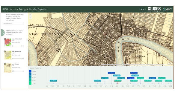
By default the website opens focused on New Orleans, as good a place as any to begin exploring the historical maps of a city. Clicking the map links in the timeline in the bottom window will add them to the ‘stack’ on the left side of the web page. From there you can adjust the visibility of each map using a convenient slider to blend the map image in and out, allowing fast and easy comparison with any of the other maps in the stack.
A few initial observations –
First, while there was a steady increase in both the density of content and the variety of information contained in maps as the USGS progressed through the 20th century, there was, sadly, a steady erosion in the practice of cartography as an artistic medium. I understand the USGS’s job isn’t to make art, but visual appeal is something that draws the user to the map. The hand drawn cartography applied to the USGS maps of the late 19th and early 20th century is a wonder to behold. By comparison the current US Topo series maps have all the visual appeal of a rusted out Yugo.
Next, there’s a clear improvement in the spatial accuracy and information content between maps prepared in the late 19th and early 20th centuries and maps prepared in the 1930’s and later. This is due to the adoption of aerial photography and stereo compilation production methods starting in the 1930s. By using stereo aerial photography as a map compilation base the USGS dramatically speeded up map production while simultaneously improving map accuracy and content.
To sum it all up I’ll just say that the USGS Historical Topographic Map Explorer website is the best use of my tax dollars that I’ve seen in a long, long time!
– Brian
