Project Casey Jones

Casey Jones Cover Sheet

Yesterday I was poking around eBay looking for things I just can’t live without when I stumbled on an auction that caught my eye. One of my canned eBay search criteria – ‘aerial mapping’ – triggered a hit for an auction for a US Air Force publication on something called Project Casey Jones. The subtitle was the real attention getter: ‘Post-Hostilities Aerial Mapping; Iceland, Europe, North Africa, June 1945 – December 1946′.  I was intrigued but the eBay seller was asking far (far) too much for the document. But since this was an official USAF publication I figured there was a good chance it was already available on-line in digital format. A quick Google search turned up a the document in PDF format on an on-line library and I grabbed a copy.

As I started to read the report it dawned on me that I never really knew where the base mapping imagery came from that allowed the Army Map Service to re-map all of western Europe and North Africa quickly and accurately right after the close of WWII. I just assumed the aerial photo missions were done on a piecemeal as-needed basis by US assets or we collaborated with host countries like France or Italy to obtain civilian aerial photo coverage.

As it turns out the collection of aerial mapping imagery at the close of WWII was a far more centralized and directed effort than I could have imagined. The fact that the project was carried out so quickly, comprehensively and effectively is remarkable and is one of the great untold stories in the US Army’s topographic history.

In 1944 it was clear to senior Allied leadership that Germany’s days were numbered and thinking started to turn to projects that would help secure the US position in post-war Europe. A huge issue that had emerged from both the ground and air campaigns in Europe was the lack of accurate and up-to-date maps and air charts. During the war the Allies’ mapping services, like the US Army Map Service, scrambled to meet the demand for large and medium scale maps. They often relied on outdated local maps of dubious accuracy, supplemented where possible by photo mosaics or photomaps based on aerial photography taken by reconnaissance aircraft. The science of mapping using stereo aerial mapping photography was well understood at the time, and the US Army Air Force (USAAF) had the necessary cameras and aircraft at their disposal, but flying long, slow and precise flight lines over enemy held territory was out of the question while both sides were still shooting at each other.

Allied military leadership realized that once the shooting stopped there would be a very short window of opportunity during which they would be able to fly photomapping coverage of most of western Europe. The idea was to get the job done while the American’s still had the political clout and the resources in Europe. The US Government and the USAAF applied a carrot and stick approach to the problem. In concert with the British Royal Air Force, the USAAF would fly the conquered territories (Germany, Austria, Italy, etc.)  at will (“we won, you lost, tough luck”), and the Allied, newly liberated or neutral nations (France, Spain, Switzerland, Netherlands, Belgium, etc.) would be offered a copy of all aerial imagery collected over their territories (“we’re your friends and we’re just helping you get back on your feet”). In the end it worked, and over two million square miles of new stereo aerial imagery was collected in about 18 months.

Casey Jones Airfields

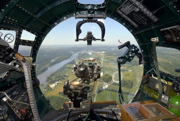
The Project Casey Jones report brings to light some very interesting historical tidbits. The first were the technical issues. How do you keep a big, heavy bomber like a B-17 on a straight, steady course for hundreds of miles? The answer turned out to be ingenious. After the pilots failed multiple early attempts to keep the aircraft flying straight and level the job was turned over to the bombadiers and their Norden bomb sights. Since the Norden bomb sight effectively took control of the aircraft once the bombing run to the release point was initiated – controlling aircraft attitude, direction of flight and compensating for wind drift and other factors – it became a relatively simple matter to re-program the sight so that visual check points along the photographic flight line became the ‘release points’, and the bombardier actually controlled the flight by flying from check point to check point along the flightline path using the Norden. Simple but effective.
norden-bombsight

Norden bomb sight in the nose of a B-17. From this station the bombardier took control of the aircraft and flew from check point to check point along the flightline. Many of the flightlines were 200 or more miles long

The other interesting factor was quality control. The USAAF was flying to meet US Army Corps of Engineer (Army Map Service) requirements and had to adhere to mapping imagery standards for image overlap, side lap, aircraft attitude, cloud cover, haze and other factors. In the beginning the rejection rate of aerial imagery was unacceptably high – some flight crews only hitting the mark 20% of the time. Part of the problem was a lack of familiarity with the mission, part was mechanical problems with the installation of the mapping camera systems, and part was weather and atmospheric conditions. To help solve the problems and improve the success rate for the photo missions the Corps of Engineers put photomapping officers and technicians in each of the squadrons. These personnel would grab the film as soon as the aircraft landed, develop it and quickly review it while the flight crews were still in the area. They could do a quick post mortem on the success or failure of the flight and provide the crews with valuable feedback on what was needed on upcoming missions. As air crew experience increased the success rate increased, and towards the end of 1946 the success rates for each mission hovered around 60%.

Other factors worked against the project; weather during one of the worst winters in modern memory (1945 – 46), high personnel turn-over rates caused by rapid demobilization and political issues that delayed or canceled overflight permission. But in the end the USAAF was successful, and Project Casey Jones was effectively complete by September 1946.

So what became of the two million square miles of mapping photography flown during Project Casey Jones? It was immediately transferred to the the Army Map Service and was used as a primary cartographic data source for at least the next 20 years. It was used in the wide-scale production of up-to-date tactical and operational scale maps of western Europe by American and British military mapping agencies, maps that supported the operational backbone of NATO well into the 1960’s and perhaps beyond.

Brian

Ted Abrams

Yesterday the December issue of American Surveyor magazine appeared in my mailbox. American Surveyor is one of the few trade publications I read from cover-to-cover every month, and it’s one of the very few I’d gladly pay a subscription fee for. But since the publisher, Cheves Media, provides it free of charge all the better.

American Surveyor DecCover2015full

This month’s issue hits it out of the ballpark. The cover is one heck of a teaser – a beautiful shot of the John Bird transit telescope used by surveyors Charles Mason and Jeremiah Dixon to establish the boundary between Pennsylvania and Maryland just before the Revolutionary War. This is the famous ‘Mason – Dixon line’ that today is viewed (incorrectly) as the cultural and political dividing line between the American North and South. Mason & Dixon’s achievement is an important topic in the history of topography in the Americas and we’ll have more on it in a later post.

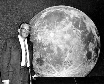
Today however we’ll focus on the other key article in the magazine – a short overview of the achievements of Ted (Talbert) Abrams, an early pioneer in the science of photomapping and and photogrammetry. Abrams was one of the quiet heroes of topographic history, someone most have never heard about but who’s accomplishments revolutionized science, established an industry and helped found the geospatial profession many of us practice in today.

Ted Abrams

Just what were Ted Abrams’ achievements? He effectively invented the business of photomapping. It was his experience as a US Marine Corps reconnaissance pilot during WWI that convinced him that aerial photography could be used to make highly accurate maps. At the time traditional mapping technology required the use of ground survey and field verification crews to literally walk and survey the areas to be mapped, usually using laborious plane table survey methods. The process was slow and expensive. One of the earliest uses of aircraft during WWI was to take vertical photos of battlefields for the creation of map substitutes. These were simple photo mosaics annotated with things like road and town names, but they filled a critical need.

Coming out of the war Abrams was convinced that photomapping could not just be a viable business, but could revolutionize the science of large scale mapping over broad areas. Ted Abrams was part pilot, part scientist and part entrepreneur, and all genius. Where no industry existed, he developed the techniques and the instruments necessary to capture and process tightly controlled areal mapping photography and compile accurate maps from that data. He then developed the business model that made it all profitable. He also helped develop a lot of the science behind the processes involved in photomapping. You can’t claim your maps and photo mosaics are accurate unless you can prove the mathematics and geometry that went in to making them, and Abrams was an early pioneer in developing the mathematical principles behind processes like aerotriangulation.


Ted Abrams was also a life-long patriot and a proud Leatherneck. During WWII he set up schools that trained thousands of Marine Corps photo mapping and photo analysis specialists, and his techniques and textbooks were in wide use across all the military services. One of his simplest yet greatest accomplishments was the invention of  the folding pocket stereoscope. This stereoscope was manufactured by the hundreds of thousands by the Abrams Instrument Corporation and other manufacturers and became the indispensable tool of photo interpreters, surveyors, cartographers and intelligence analysts around the world.

Frost Course Module 3 blow-up

Invented by Ted Abrams in 1942, the simple folding pocket stereoscope has been the indispensable tool of topographers for over 70 years. They are still in wide use today

After the war Abrams’ business flourished as America went on a building boom. He built Abrams Aerial Survey into the leading aerial survey firm in the United States and the Abrams Instrument Corporation became a leading supplier of aerial photography, photogrammetry and aerial photo analysis instruments.

Ted Abrams was a founding member of the American Society of Photogrammetry (now the American Society of Photogrammetry and Remote Sensing (ASPRS)) and much of his pioneering work made its way into the first editions of the industry’s standard reference, the Manual of Photogrammetry.

Manual of Photogrammetry

In recognition of Abrams’ contributions the ASPRS presents the Talbert Abrams Award every year to ‘encourage the authorship and recording of current, historical, engineering, and scientific developments in photogrammetry.’

One last example of Ted Abrams’ genius. He came out of WWI with a clear understanding of the limitations of current aircraft designs when used as platforms for aerial cameras. Abrams knew he needed a more stable aerial survey platform designed around the needs of the camera system and crew. In the 1930’s Abrams sat down and designed what became the world’s first dedicated aerial imagery platform – the Abrams P-1 Explorer.

Abrams_P-1_Explorer

First flown in 1938, it was specifically designed for the mission of acquiring aerial mapping photography. The P-1 incorporated a number of unique design elements, including a pusher-type engine arrangement designed to keep leaking oil and fluids from smearing the camera lenses (a serious problem with conventionally laid out aircraft using rotary engines), and it was one of the earliest aircraft to utilize Plexiglas for windows. In fact the nose layout made its way into WWII military aircraft designs, particularly the nose arrangement of the early B-24 Liberators.

Unfortunately the P-1 design was a victim of war. By the time the aircraft became operational proved itself as an outstanding aerial camera platform WWII had broken out. The US Army Air Corps looked at the design and deemed it too slow and too vulnerable to enemy fire. Ted Abrams realized he needed to work on ways to mount mapping camera systems in fast moving fighters and modified bomber aircraft and threw himself into the task without looking back. Only one model of the P-1 was ever built and it remained in operation in the US until 1948.


A fascinating aircraft designed by a true genius and pioneer in our industry. We truly do stand on the shoulders of giants.

Brian

US National Grid – An Update

It’s been a while since we’ve discussed the US National Grid, but I was recently brought back to the topic.

Last week at work I got involved in a debate with some of our emergency response managers and operators on the issue of map grids. We are putting together a comprehensive emergency operations dashboard (web map) and I thought it would be useful to have a standard grid available that all agencies can use, understand and reference their response efforts against.

My first reaction was to just go ahead and use the US National Grid (USNG). It is easy for us to create web and paper maps that display the grid, it is easy to understand and its use is mandated by federal policy (or so I thought). I was quickly shot down. Someone in the ops group produced a PDF of a map displaying an arbitrary alphanumeric grid. This grid was generated a half decade ago by someone who is long gone and nobody knows where the CAD file is that holds the original grid drawing. Yet this grid has been ‘approved’ by a large federal agency with wide ranging authority and so it was deemed the grid for emergency responders to use. It didn’t seem to bother too many folks that the only place the grid existed was on this small scale PDF. No way to update the underlying map or photo, no way to bring this map into other products. It didn’t matter – this was the approved grid, period.

What really got my attention was when one of our emergency services coordinators, a good guy who’s had (by his estimate) hundreds of hours of federally mandated (and developed) training on disaster response, told me that in all his training classes he’d never even heard of the USNG.

Your tax dollars at work.

In the end we gave up and one of our sharp geospatial analysts was able to recreate the grid as a georeferenced polygon layer using the Data Driven Pages functionality in ArcGIS. So now this approved grid exists not as an overlay on a static paper product, but as a scalable data layer that can be easily incorporated into paper or web based map.

But still, USNG soldiers on. I snuck it in as a data layer in this operations dashboard. It’s turned off by default, but it’s there if needed. I guess everybody’s happy. The ops guys get their arbitrary grid that has no real relation to any recognized spatial coordinate system, but hell, it’s approved! I get a grid that may (or may not) be approved and mandated by the Feds, that every emergency responder gets schooled on when he/she goes for federally mandated training (or maybe not), and is supposed to be the standard emergency response grid system in use by the federal government (perhaps).

Again, your tax dollars at work.

In working through this issue and trying to find documentation and guidance on the mandated uses of USNG I happened on this interesting site, the US National Grid Information Center:

USNG Information Center

This site holds a lot of great information on the USNG and its applications, and I encourage everyone who deals with USNG or MGRS to spend some time going through the resources.

Even more interesting, it appears the site is not maintained or supported by any federal agency or the FGDC (the ‘father’ of the USNG concept). This is all a private effort and the site is supported by the SharedGeo organization.

So here’s an example of your tax dollars not at work, and it’s a good thing!

Brian