Aviation GIS

Time for a little venting and praise. Our team at The World’s Busiest Airport does pioneering work on an amazingly broad range of geospatial issues and, frankly, we don’t get the recognition we deserve from our own airport leadership. It’s shameful that after over eight years of groundbreaking work and international recognition from the aviation GIS community we still have senior management that thinks all we exist for is to make pretty paper maps. You can (repeatedly) lead a horse to water, but you can’t make them drink, even when they are dying of thirst.

So let me toss an atta-boy to one of the best geospatial teams I’ve had the honor and pleasure to work with in over 30 years in the industry. You guys are outstanding, and I’m particularly pleased with how everyone on the team has grown over the past eight years. Nobody stays static – you are all pushing the boundaries and breaking through to find new and innovative ways to support the enterprise.

Here’s a (very) small sample of the kind of work our team does. None of this is pie-in-the-sky. We do this kind of stuff every day


Great job team! This is one grumpy old topographer that truly appreciates you.

– Brian

Army Geospatial

My good friend Bill Farr sent me this YouTube link yesterday showing US Army Geospatial Engineers in what appears to be a planning exercise in preparation for deploying to Africa as part of the Ebola relief effort. The video was filmed at the Army Geospatial Center on Fort Belvoir, VA (the old Topographic Engineering Center) and it shows enlisted geospatial analysts running through different scenarios.

I post the video mainly for comparison. A lot of my civilian GIS colleagues really have no idea just what geospatial engineers in the US military do. This is a short but good snapshot of the kinds of projects Army geospatial engineers work on day-to-day.

– Brian

Something Interesting From Trimble

I’ve been expecting one (or more) of the major survey & GIS data collector manufacturers to come out with something like this for some time now. I’m not surprised that Trimble was first out the gate. It’s called the Trimble Leap.

Trimble Leap

If you understand what’s going on with this new product you realize it’s a fascinating concept. It’s not just a small GPS receiver mated to a smartphone via Bluetooth – that capability has been available for a few years now. What this receiver provides is more advanced GPS signal tracking and the integration of Trimble’s RTX GPS data correction service. Trimble’s RTX service is a virtual reference station (VRS) system that receives GPS data corrections using the smartphones’s cellular data connection. This allows the Leap receiver to provide on-the-fly GPS positional accuracies that are less than 1 meter. Remember sports fans, the best your smartphone or Garmin Nuvi can do is about 15 feet, and that’s on a good day, under open skies, with lots of GPS satellites available.

Keep in mind that the Leap is not a survey grade device. It’s a lower precision field data collection device. The kind of thing a utility company would send a work crew out with to collect manhole locations. For applications like utility data collection, sub-meter accuracy is just fine.

The Leap concept is the next evolutionary step to take smartphones into the high accuracy/precision GIS data collection role. Smarphones are really just small computers with built-in modems, so they are the ideal computing platform for applications like this. However, smartphones have one huge Achilles heel – battery life. An ‘always on’ Bluetooth connection and cellular data connection will suck a smartphone battery dry in just a few hours. This is not a Trimble issue, but something that must be taken into consideration when putting devices like these into the field to collect a day’s worth of data. Better make darned sure you’ve got that in-car phone charger along with you!

There are still a lot of unknowns with regards to the capabilities of this system. Is the Leap receiver GLONASS capable? Does it allow data collection without the RTX connection? What about cost? I’ve read reports that the Leap hardware will run just under $1,000 and the RTX data correction service will be an additional $400/year per device. If you have any understanding of how much RTK compatible GPS receivers cost, and how much a VRS data service costs you will realize that $1,000 for the hardware and $400/year for the data service is a bargain.

Where I think Trimble stumbles is that they have slaved the Leap to their Terrain Navigator Pro (TNP) software. My impression is that TNP is a moribund product and Trimble is trying to breath some life into it by slaving it to a very capable hardware package. My hope is that Trimble quickly migrates the Leap software interface to other products like its own TerraFlex cloud service and even develops a plug-in that allows Leap data streams to be read by products like ArcGIS Online mobile applications.

– Brian

The 2014 ESRI UC

Well kiddies, I’m back from San Diego and the 2014 ESRI International User Conference. This is my third conference in five years, and it’s starting to feel like Groundhog Day.

Now please, do not get me wrong – it was a very good conference and in some respects it was a great conference. I and my team learned a lot and picked up a lot of new information.  But in the plenary and in the technical sessions and presentations side it was the same drumbeat we’ve been hearing for the past several years – ‘rich’ web maps and apps (could someone in ESRI please tell me just what ‘rich’ means?), ArcGIS as an integrated system, not just a bunch of parts, ArcGIS Online, ArcGIS Online, ArcGIS Online, yaddah, yaddah, yaddah.  In the Solutions Expo (i.e., vendor displays) it was the same vendors, many in the same locations, showing the same stuff, giving the same spiel, etc.

You know, Groundhog Day. C’mon ESRI, mix it up a bit. It’s getting a little stale.

OK, that’s out of the way.  Let’s change tack. If you listened closely to the presentations and have been paying attention to what ESRI’s been doing in the past few months you were able to tease out some great information regarding new and emerging capabilities. Let’s start with one of ESRI’s current flagship product, ArcGIS Online.

If anyone reading this blog still doubts that ESRI considers ArcGIS Online and web mapping a central part of ESRI’s GIS universe then this UC would have set you straight. The message was obvious and unmistakable, like a croquet mallet to the head. ArcGIS Online is here to stay, is only going to get bigger, and if you are going to play in the ESRI sandbox you need to know (and buy into) ArcGIS Online. I didn’t attend a single ESRI session, whether it was the plenary or a one-on-one discussion with a product expert where the topic of ArcGIS Online integration didn’t pop up early and often. Most vendors I talked to – and certainly all of those that ‘got it’ – had ArcGIS Online integration as a key selling point for their product or service. Heck, even IBM with their painfully complex work order management program called Maximo ‘got it’ and touted how I could now ‘easily and seamlessly’ integrate ArcGIS Online feature services with Maximo. Anybody who knows Maximo knows it doesn’t do anything ‘easily and seamlessly’. I don’t really think Maximo can use hosted feature services from ArcGIS Online, at least not yet. The REST endpoints I saw Maximo consuming looked like dynamic map services. But at least the IBM sales team took the time to read the memo from Redlands.

ArcGIS Online

The ArcGIS Online product space was the single biggest product presence ESRI had set up in the Expo. It was huge, and a reflection of the importance ESRI places on the product

ESRI’s incessant chatter about ArcGIS Online would have fallen flat with those who are long time users of the product if ESRI had not done a product update just a few weeks ago. The July update of ArcGIS Online included a number of significant improvements and new features that signaled to those who know the product that ESRI is serious about ArcGIS Online being more than just a toy for making simple web maps. The upgrades in system security certification, administration tools, data management, data integration, analysis and cartographic tools shows ESRI has full confidence in ArcGIS Online as a serious enterprise tool.  I’ll admit that a few years ago I was having doubts that ESRI would be able to pull this off. Today I’m convinced that ArcGIS Online and web mapping is the most significant development in geographic content delivery since the invention of the printing press.

This year I spent more time wandering the Solutions Expo hall than I did attending the technical sessions. In past years there were sessions I felt I just couldn’t miss, but this year my technical needs were somewhat less well defined and I wanted to spend more time speaking with the vendors and visiting the ESRI product islands. It was time well spent.

One of the focuses (foci?) of this year’s plenary presentation was the issue of ‘open data’. Open data is nothing more than data that is available free to any user. Open data can take any format (though it is understood that for data to be truly ‘open’ it needs to be available in a non-proprietary format). For decades the federal and state governments have made GIS data available in a variety of GIS formats. A good example of this is census data. The data for most censuses held in the last 40 years or so is freely available in GIS format from the US government. It’s easy to pull that data into a GIS system and do all kinds of analysis against it. In fact, census data is one of the first data types that new GIS students learn to analyze in their core classes. In the same vein, many states make state-specific GIS data available from freely accessible data servers. Things like elevation data, transportation network data, hydrology, landcover and more have been commonly available for years.

However, it was often difficult for smaller government entities – cities, counties, or regional authorities – to share out their public data because of the IT and GIS management overhead involved. Let’s face it, nobody makes money sharing out free data so there’s little incentive to put a lot of resources behind the effort. As a result a lot of currently available open GIS data is pretty stale. ESRI is backing a push to pump new vitality into the sharing of open data via the new Open Data tools embedded in ArcGIS Online (see, there it is again). OK, I admit that ArcGIS Online isn’t exactly free to the organization looking to share out data, but if you do happen to be an ArcGIS Online subscriber then setting up an Open Data site is fast and easy. One of the great concepts behind ESRI’s effort is that the organization is really sharing a feature service from which an Open Data user can extract the data. This means that the data should not suffer from ‘shelf life’ issues; as long as the data behind the feature service is regularly updated the Open Data user will have the latest and greatest representation of what’s being shared.

On one of my laps around the Expo floor I stopped at the Open Data demonstration kisoks set up in the ArcGIS Online area and talked through the concept and implementation with one of the ESRI technical reps. At first I didn’t think my organization would have much use for this feature, but after thinking about they types of data we routinely pass out to anyone that asks – road centerlines, jurisdictional boundaries, parcels, etc. – I began to think this might be of some value to us. In about 15 minutes she helped me set up my organization’s Open Data site and share some common use data out to the public. If for no other purpose, an Open Data site could lift some of the data distribution burden off of us.

OpenData1

The new Open Data tab in ArcGIS Online allows the administrator to configure an open data page from which the organization can share data with the public

Another lap took me to the US Geological Survey information tables. The USGS table was set up in the Federal Government area and while most of the agencies suffered from a serious lack of attendee interest (and I pity the poor souls who had to man the Veteran’s Administration table), the USGS tables were doing a good business. The USGS reps were stirring the pot a bit. It seems that there’s a move afoot in the USGS to do away with the National Atlas. I’m not sure yet how I feel about this move. Clearly elimination of the National Atlas is a cost cutting move (and the USGS makes no bones about it on their website), but if the same digital data can be made available via other portals, like the National Map portal, then this may all be a moot point.  Still, this is the National Atlas and as such should be a point of pride not just for the USGS but for the nation. If for no other reason than that I’d keep it alive. The USGS reps working the tables were clearly pro-National Atlas and were running a petition campaign to garner support to keep the program going.

I also spent some time discussing the new US Topo series of maps with the USGS reps. If you’ve read any of my posts on the US Topo maps you know that from a cartographic perspective I think they stink. The map base – imagery – is poorly selected and processed and the maps looks like crap when printed out. That’s the basic problem; the US Topo series are compiled as though the intent is to print them out full scale for use in the field. They carry full legends and marginal data. However, it’s clear they were compiled specifically to look best on a back-lit computer screen. When printed out the maps are dark, muddy and the image data is difficult to discern. When I brought this up to one of the USGS reps she turned her badge around to indicate she was speaking for herself and said, “I agree completely, and we get a lot of complaints about the visual and cartographic quality of these maps.” Here’s hoping the USGS doesn’t go tone-deaf on this issue and takes steps to improve the quality of the US Topo series. She also let me know that there’s growing support within the USGS to provide the US Topo series maps not just in GeoPDF format but also in GeoTIFF. This would be a great move, especially if the USGS provided them in a collarless format for use in systems like ArcGIS for Desktop.

I took the time to mosey over to the Trimble display area and talk to a rep about my favorite Trimble issue – the lack of a Google certified version of Android on their very capable (and very expensive) Juno 5-series of handheld data collectors. I’ve bugged Trimble so much about this that I have to assume my picture is hanging on a dartboard in the executive conference room at Trimble’s headquarters. I got the same response out of the Trimble rep that I’ve been getting for about a year now, “We hear it’s coming but we don’t know when”. Yeah right.

After I left the Trimble area I found myself a few rows over at the table of a company I’d never heard of before, Cedar Tree Technologies. It was just a couple of guys with a couple of pieces of hardware, but my eye caught something that looked a lot like a beefed up smartphone and the guys at the booth were eager to give me their story. It seems that Cedar Tree Technologies is a brand new spin-off of Juniper Systems, a company that’s been making rugged handheld systems for the surveying and GIS community since the 1990’s. Cedar Tree’s specific focus is on the Android OS, and each of the devices on display were running Google certified versions of Android 4.2. The device that caught my eye was the CT4. The CT4 is what it looked like – a ruggedized smartphone that runs on Android. It looked like an OK product with very good specs – a quad core processor running at 1.2 GHz, a 4.3″ Gorilla Glass display, and 8 mp camera, a 3000 mAh battery, Bluetooth and an IP68 rating.  It did have a few drawbacks – only 16 gig of system memory and a 3G (not 4G or LTE) cell radio, and I forgot to ask if it was fully GNSS capable. But here’s the kicker – this damned thing is only $489! Roughly one third the price of the baseline Juno 5, yet it looks like it offers 3/4 or more more of the Juno’s capability. You can bet I’ll be contacting Cedar Tree about borrowing one of these for an evaluation.

Cedar Tree1

 He’s smiling because he thinks he’s got Trimble beat in the Android space. I think he might be right!


Cedar Tree2

 The Cedar Tree Technologies CT4. Perhaps the first truly usable Android-based field data collector

OK, I don’t want to get too far into the weeds on other topics of interest, so let me just do some quick summaries:

  • I talked to Trimble, Leica, Carlson, Juniper and Topcon reps about their software offerings. All plan to remain tightly wedded to the Windows Mobile 6.5 OS (a.k.a., Windows Embedded Handheld), which hasn’t had any significant updates for over 2 years. Many of the reps indicated that the mobile version of Windows 8 still has some issues and they are very reluctant to move in that direction. So it looks like the industry will be stuck with an archaic and moribund OS for some time yet
  • What the world needs, in addition to a good 5¢ cigar, is a good spatially based document management system. Lord knows my organization is in desperate need of something like this. I saw only one document management system vendor at the show, and their system has a strong dependency on ArcGIS Online (there it is again). I think this is a market area that is ripe for exploitation. The tools are now in place with ArcGIS Online and reliable cloud services to bring this type of functionality quickly and cheaply to an enterprise and I’d love to see some new developments in this area. Pleeeeze!
  • I attended a very interesting working session where the GIS team from Pierce County, WA discussed their adoption of enterprise GIS and ArcGIS Online. I felt like I was sitting through a presentation I had written about my own team’s struggles and experiences. Like us, Pierce County faced a lot of push-back and foot dragging from their IT department on implementing IT-dependent GIS initiatives, and productivity among the county’s field maintenance crews suffered. Here’s my point – for every GIS/IT success story I’ve heard or read about I’ve heard an equal number of stories where thick-headed IT departments get in the way of a successful GIS initiative. If you are IT and don’t fully support the GIS initiatives in your organization then watch out. You will wake up one day soon to find you’ve been replaced by a cloud based service. It’s happened in my organization and it’s happening across the industry.
  • How come I never heard of the Association of American Geographers? I’m not joking. I’ve been in this industry for over 30 years and have been attending trade shows for all of that time. I’ve heard of the ASPRS, the American Society of Photogrammetry and others, but never the Association of American Geographers. Seems like a good organization. May have to join!
  • Like a good 5¢ cigar, the world also needs more quality geospatial sciences masters program options. I talked to a number of the universities set up at the conference and while they all seemed to be offering quality programs, too many of them are targeted at the professional student, someone who heads into a masters program directly from a bachelors program. For example, here in Atlanta the Georgia State University offers what looks like a cracking good geosciences masters program with a focus on geospatial science, but it’s structured so that all of the coursework is classroom focused and only offered during working hours. For someone making a living in the real world this type of program really isn’t feasible. We need more fully on-line options and more local colleges and universities to offer evening and weekend programs.
  • Let’s get back on the ArcGIS Online horse and discuss a very interesting service that the developers tell me is under serious consideration. One of the gripes that users of Collector for ArcGIS have is the lousy positions that are provided by the GPS/GNSS receivers on handheld units. Keep in mind that this is not a Collector issue, but a hardware issue. One of the improvements ESRI is looking at is a subscription based correction service for use with Collector. It will probably work like this – collect a point or a series of verticies and when they are synced with the ArcGIS Online server the points first pass through a correction service before being passed on to ArcGIS Online. This will likely be a single base station correction solution, but it could offer sub-meter accuracy if using a data collector with a more advanced GPS/GNSS receiver (sorry, this will not work with your iPhone or Android smartphone because of the low quality receivers they use). Sort of like on-the-fly post processing. A very interesting concept, and it could move a lot of hardware manufacturers like Trimble, Topcon and Leica to put out low(er) cost Android-based field data collectors with improved receivers

Before I go, some kudos:

  • To the City of San Diego. I can’t think of a better place to hold this conference
  • To GIS, Inc for a wonderful dinner cruise with NO sales pressure (Mrs. OldTopographer just loved it!)
  • To Andrew Stauffer from ESRI and fellow BGSU grad. Andrew provided invaluable support to our organization over the past few years while we worked through our ArcGIS Online implementation issues. I finally got to meet him in person and thank him
  • To Pat Wallis from ESRI who proved you can hold down a serious job and still be a 1990’s era ‘dude’
  • To Courtney Claessens and Lauri Dafner from ESRI who entertained all of my dumb questions about Open Data
  • To Kurt Schowppe from ESRI. I’m sure my pool party invite got lost in the mail <grin>
  • To Adam Carnow, for putting up with all of my other dumb questions and requests
  • To all the great people I bumped into at random and had wonderful conversations with

And finally, it was good to see my alma mater making a showing at the Map Gallery exhibition. Go Falcons!

BGSU poster

– Brian


Off To San Diego!

It’s off to San Diego for the annual gathering of the faithful, also known as the 2014 ESRI International User Conference.

Esri-international-user-conference-logo

Looking forward to hear what Uncle Jack has in store for us and picking up mountains of geo-swag from all the exhibitors (I’m bringing along an extra large suitcase just to hold all the cool stuff).

And maybe, just maybe, I’ll be able to find a Trimble rep who is willing to give me a straight answer on why, almost a year on, Trimble still hasn’t released a certified version of Android for their very expensive and potentially very capable, yet unnecessarily crippled, Juno 5 data collectors.

So we’ll see you back here in a week with a report on all the neat stuff I discovered!

– Brian


ArcGIS Online (Finally!) Gets Labeling

Time for some polite applause.

Yesterday ESRI released an update to ArcGIS Online. This is a significant update because it adds a number of enhancements that the user community has been requesting for quite some time.

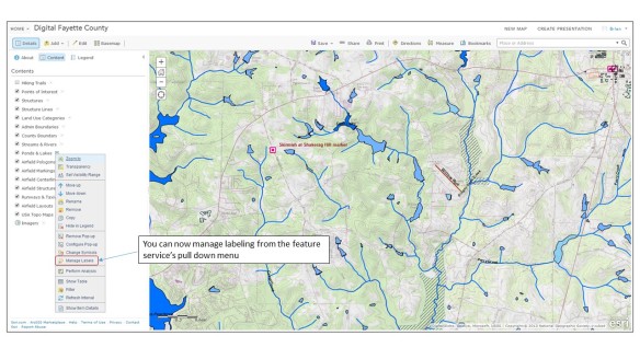
The first enhancement we’ll talk about is labeling. Labeling of hosted feature services has to be the #1 update requested by (paying) customers since ArcGIS Online launched in 2012. A hosted feature service is a type of map service that is stored (or hosted) in ESRI’s ArcGIS Online cloud. Before yesterday the only way to get labels into your ArcGIS Online web maps was to stage your data as a dynamic map service on your own internal servers running ArcGIS for Server or create a cached map (tiled) map service. Both of these options are expensive in cost and overhead. With yesterday’s update you can generate labeling against hosted feature services from within the web map interface.

Digital Fayette County 1

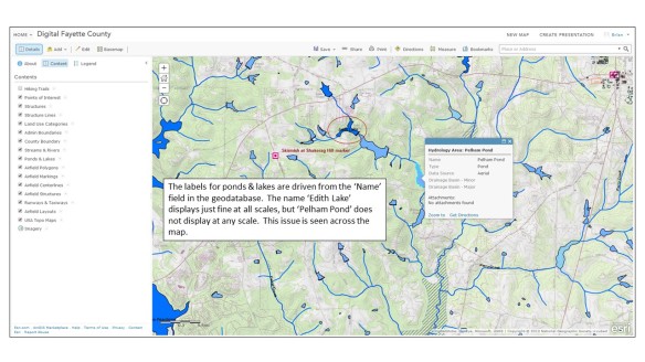
The labeling options are fairly limited. The user gets to choose label placement (above, below or on the line.), which geodatabase field(s) will drive the label name and some basic text formatting options. The line/polyline labeling works well, but there appears to be some major issues with polyogn labels not displaying, even in areas where there are no competing labeling issues.

Digital Fayette County 2

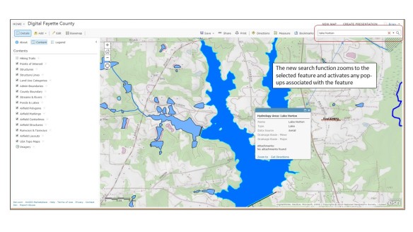
Another critical update is a new search function. ESRI has offered filtering against map layers for some time, and that’s a type of search, but that functionality is intended mainly to generate new focused map layers. For this new search functionality ESRI decided to embed the feature in the web map interface rather than access it from a specific map layer. At first I was a bit confused as to what ESRI was trying to achieve with this new feature – I expected any new search function to be driven from the map interface. However, once I played with it I see ESRI’s logic, and I like how they implemented it.

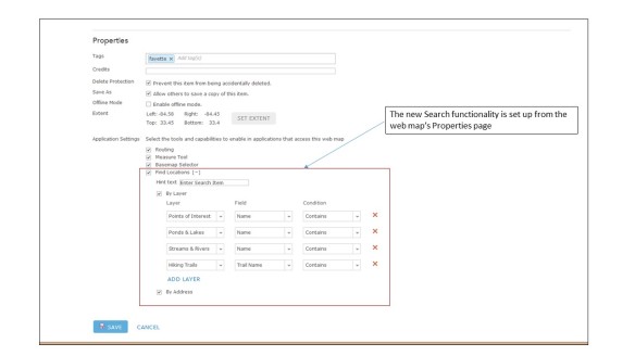
The search criteria is first set up on the web map’s Properties page.

Digital Fayette County 3

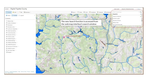
Once the search criteria are set up on the Properties page the user can access the functionality from the web map’s search window.

Digital Fayette County 4

The Search function will zoom to the selected feature and activate associated pop-ups.

Digital Fayette County 5While this is a very simple search functionality it works well and I like how it was implemented.

There are a host of other key updates. I won’t go into detail on them, but new features that have caught my eye include:

  • The ability to display related data in web map pop-ups
  • An update to the Basic Viewer map template that supports searches. The Basic Viewer is one we use heavily in our organization and I’m glad to see this one get a key update
  • The new GeoForm template that allows users to add data to a web map via a web form instead of though a pop-up
  • When exporting data from a web map in file geodatabase format all attachments (pictures, documents, etc.) get exported along with the data

This is just a first and fast look at the new features. There’s a lot of good stuff in here and it’ll take me some time to play with it all. In a few weeks I’ll be out at the annual ESRI International User Conference and I’m sure these new features will get a lot of coverage during the Plenary sessions. Something to look forward to!

– Brian


An Interesting Challenge

I caught this posting the other day on the C4ISR & Networks page:

Geospatial Sensors

This challenge got me thinking. Most of the requirements could easily be met using something like LiDAR – flood the target with enough laser sensors and you could track all the way down to the crickets chirping in the grass, in 4D. But the real challenge in this requirement is for a passive sensor that does not give away the user or sensor location. LiDAR and other systems that could tackle this challenge are all active systems – continuously bathing the target area with active signals in order to collect data. This makes them easy to detect with fairly rudimentary electromagnetic spectrum receivers (i.e., radios tuned to the right frequency).

So I started thinking. How could this problem be tackled with a passive collector system? For an old topographer like me the answer is simple – photogrammetric technology!  A pair of video cameras that collect high resolution imagery in a variety of spectrums (visible and passive IR) and have modern night vision capability could easily collect real time stereo still imagery (3D) and video (4D). They’d have to sit along a calibrated baseline, but that’s easy to establish using military grade GPS. All of this technology could be easily squeezed into fairly small, man-portable units. The data would have to be uploaded to computers for post-processing and visual display, and for real or near-real time use that implies some sort of a communications link. But still, the data collection part seems to me to be a simple application of available technology.

Hmm… maybe it’s time I hang out my shingle as a defense industry consultant!

– Brian


Some GNSS Musings

First things first – GNSS is the new GPS.  Actually, GPS is a subset of GNSS. GPS stands for Global Positioning System, GNSS stands for Global Navigational Satellite System. For decades folks refereed to any and all satellite navigation systems as GPS, and for good reason – the US Global Positioning Satellite system was the only game in town. However, the term ‘GPS’ properly describes just the global positioning system established and maintained by the United States. Now that the Russian GLONASS system is operational, and systems from the European Union, China and perhaps other players (India?) are coming on-line, the term for ALL space-based satellite navigation systems has shifted to GNSS.

OK, now that that’s out of the way.

I spent the last two days in training finally learning how to run Trimble’s TerraSync and Pathfinder Office software.  We’ve had TerraSync and Pathfinder Office software in our office for years, but never got any formal training on how to use either package.  The training was actually very good, and I can see now why a lot of surveying and engineering firms prefer TerraSync over GIS-centric packages like ESRI’s ArcPad.

The class was taught by one of the training and support personnel from our local vendor, NEI, and he did a great job.  Woven throughout the class are discussions about GPS, datums, coordinate systems and issues like unanticipated coordinate system shifts due to improper datum selection or datum mis-matches between the software and virtual reference station (VRS) datums.  We spent a good deal of time in the field actually experiencing the impact of changing datum selections in the software (for example, the shift seen when selecting NAD83 vs. NAD83 HARN).

So this class got me thinking again about GNSS and data quality and accuracy…

In the olden days, like before the turn of the century, these datum shifts generally didn’t concern GIS folks.  The shifts introduced by any datum mis-match were well within most folk’s error budgets.  In most cases we were ecstatic when GPS got us within a few dozen feet of the features we were collecting.  When the accuracy standard of the 1:50,000 topographic map you were using as a base was +/- 50 meters having GPS points a dozen or so feet off was no big deal.  In fact, we were tickled pink to be able to get that level of autonomous GPS accuracy.

Today things are much different. Improved GNSS software, antenna designs, the open availability of reliable GPS and GLONASS signals and the wide availability of GPS augmentation services like WAAS and local virtual reference stations (VRS) means that these systems are capable of sub-meter, often sub-foot, accuracies. That’s just for GIS data collection.  Survey-grade GNSS systems are capable of real-time accuracies to tenths of a foot. Suddenly datum shift errors of even one foot become very, very important for high precision data collection and surveying.

One of the biggest problems people in my line of work face is a general lack of understanding of GNSS in the GIS and civil engineering fields. In particular, many professionals lack up-to-date training and working knowledge of GNSS system capabilities, limitations and application to their line of work.  Evaluating and planning for the potential impact of things like datum shift on GNSS-based surveys or data collection projects is something they can’t comprehend largely because they haven’t been trained on it and, perhaps most important, have’t been forced to consider it when planning or managing a project.

Sadly, I’ve met far too many people with a GISP certificate hanging on their wall who couldn’t tell me the fundamental difference between the NAD 27 and NAD 83 datums, and I have yet to meet a single civil engineer who is not also a licensed surveyor who could explain to me the importance of knowing the datum his or her CAD drawing coordinate system is based on.  Yet both of these groups – the GIS professional and the civil engineer – have a fundamental interest in controlling the overall accuracy and precision of their work.  For the GIS professional it’s a matter reputation and trust.  For the licensed civil engineer it could be a matter of putting his or her work at legal risk.

If you work in the GIS field you can not call yourself a GIS professional unless you have a fundamental understanding of datums, coordinate systems and the importance of applying this knowledge to your workflows.  A strong knowledge of datums and coordinate systems is one of the foundational building blocks of our profession, and since so much of what we do these days is GNSS-based it makes it equally important to have a strong understanding of the impact different datum selections can have on the spatial quality of our data.

I’ve said before in this blog that those GIS ‘professionals’ who consider GIS to be little more than making web maps are headed to extinction. Here in the Atlanta metro area it would take me about an hour to hire a busload of web developers who can make web maps (and this includes time out for a stop at Starbucks). If that bus accidentally rolls into the Chattahoochee River and everybody drowns I can get another busload just as fast. However, the number of GIS professionals I’ve run into who can tell me the anticipated shift in State Plane (NAD83) and State Plane (NAD83 HARN) coordinates wouldn’t fill the first row of that bus.

For the civil engineering community the issue is less obvious but just as critical. GNSS-based surveying and data collection is becoming the norm on many projects. It is faster, cheaper and just as accurate as conventional surveys under the right conditions. This means civil engineers will be incorporating more and more GNSS-based data into their designs and relying on GNSS for jobsite control, machine control and as-built data verification. While the task of establishing project control, setting up survey equipment configurations and managing project survey requirements will fall to the the project surveyor, the project engineer still has overall responsibility for ensuring things are built to design.  If the project stakeout is a few feet out from the design drawings it may not be because the instrument operator has a hangover; it may be because the design work was done in one datum and the GNSS survey unit is set to another. Being able to identify a potential datum shift problem is a key skill for civil engineers working in today’s GNSS-based world.

– Brian

The State of Mobile GIS Software

Over the past six months or so I’ve been doing a lot of casual testing of the various mobile GIS platforms available on the market today.  Right now is an ideal time to discuss the offerings because just in the past week we’ve had an update to a key application in this arena (Collector for ArcGIS), we are on the verge of having an interesting new hardware player enter the market (Garmin’s soon to be released Monterra handheld GPS) and several vendors are dropping serious hints about where they see their products headed in 2014.

I was ramping up to do a lengthy blog post on this when I dropped by Alex Mahrou’s always interesting RockyMountainGeo GIS blog and was surprised to see he had already done all my work for me.  Back in October Alex did a great overview of the current offerings in a posting titled Enterprise Mobile GIS Software Functionality.  All I can do is add minor updates to some of his information and add a few of my own observations.
I like the switchboard analogy!
The single biggest update is the newest version of Collector for ArcGIS (version 10.2) that was released last week for the iOS and Android platforms.  This version addresses one of the two biggest complaints about earlier versions of Collector – polyline and polygon data collection.  It also offers an improved user interface and well thought out workflows.  While the Android version still has some rough edges, the iOS version is a polished, smoothly functioning app that reflects ESRI’s mature experience in developing for Apple’s mobile operating system.  It is a very good app.
Where ESRI seems to be unnecessarily holding back is off-line data collection and editing, and data synchronization.  As Alex notes, ESRI informally promised that this feature would ‘absolutely, positively’ be incorporated into Collector before the end of 2013.  It now looks like we’ll have to wait until sometime in early 2014, when ESRI plans for a significant overall upgrade to Collector, perhaps better positioning it within their enterprise software offerings.  In my opinion ESRI missed the ball on this one.  Incorporating off-line data storage and editing in the iOS and Android operating systems isn’t hard to do; Trimble had it available almost six months ago in their initial release of TerraFlex.  I understand there are other issues at play here – background map data caching and the incorporation of operational layers (both something Trimble’s offering lacks), but ESRI still could have incorporated basic off-line functionality in this new release and just built on it for the upcoming major release.
Trimble’s TerraFlex is an app I tested back in June and was initially very impressed.  Where most of ESRI’s mobile offerings (Collector, ArcGIS App, ArcGIS for Windows Mobile) require some expensive back-end infrastructure – ArcGIS Online, Portal or ArcGIS for Server – TerraFlex offers a far simpler mobile solution paradigm.  Everything is cloud based and single fee.  You pay your money and you get everything TerraFlex has to offer, and all for a relatively paltry price as compared to ESRI’s mobile solutions in the same marketplace.  Of course, this easier to use solution comes at a cost (pun intended) – what the initial release of TerraFlex didn’t offer was pretty extensive; no background map caching, no data editing either on the device or in the desktop interface, no operational layers, and some very limited data export options.  On the other hand, what TerraFlex does offer is pretty impressive given the price: off line data storage and sync, mature and stable apps not just on the iOS and Android platforms, but Trimble also had an app available for the Windows Embedded Handheld OS right out of the gate.  Trimble wasn’t about to leave out the thousands of Trimble customers running their Juno handhelds who are still stuck with a dying Windows OS.  Kudos to Trimble on this.
Trimble indicates many of these shortcomings will be addressed in 2014, and Trimble seems poised to leverage what they do best – allow TerraFlex to incorporate high precision GNSS positions (including RTK-based solutions) into the data collection stream.  This could turn TerraFlex from a mere mapping grade data collector into a serious high precision data collection tool.
In his blog post Alex discusses Fulcrum.  To be honest, this is an application I’ve known about but have not had a chance to test.  Looks like I’ll have to take it for a spin sometime soon.
So as 2013 draws to a close where are we at with mobile GIS solutions?  The best analogy I can think of is that of a ballplayer with a lot of potential who’s just been called up to the majors.  His batting stats are getting better with each game, but he still has problems connecting with the ball.  The potential is there, he just needs more time. So it is with mobile GIS apps.  Most are still somewhat of a ‘swing and a miss’, but they are getting close to smacking the ball out of the park.  Whether it’s off-line data collection with ESRI’s offerings or TerraFlex’s incorporation of cached maps, in-app editing or incorporation of high precision position feeds, 2014 is starting to look like the field will really mature and we’ll get closer to the full promise of mobile GIS.
It’ll be an interesting year!
Brian

Busting Brush with ArcGIS for Windows Mobile

Huh?  What?

OK, at work we are testing a new software package – ArcGIS for Windows Mobile.  The name is a mashup of two software package names – ArcGIS (ESRI) and Windows Mobile (Microsoft).  Yes, it is a cumbersome name.  Really, really cumbersome.

It is nothing more than a lite version of ESRI’s ArcGIS software designed specifically to run on the Windows Mobile OS.  Never heard of Windows Mobile?  Don’t worry, you haven’t missed much.  It’s an operating system that saw its widest use on mobile phones.  Notice I didn’t say ‘smart’ phones, because Windows Mobile was (and still is) an awful operating system that made every piece of hardware it touched dumber.  Same for its users.  I’m sure when Steve Jobs was yelling at his software engineers during the early stages of Apple’s iOS development he forced them to use Windows Mobile phones so they clearly understood what  iOS would not end up looking like.

Microsoft has moved on and introduced their new Windows Phone OS that is based on the Windows 8 platform.  However, their Windows Mobile OS hangs on in a few interesting places.  It’s used a lot in ’embedded’ applications, computers running inside of other things that don’t look like computers.  For example, the Microsoft Sync system that controls just about everything in my new Ford F-150 is a version of Windows Mobile.

Another place Windows Mobile has achieved a lot of market penetration is in the surveying and GPS-based data collection market.  These are highly customized hardware systems that are more than mobile phones but less that full-fledged computers, robust devices dedicated to a narrow set of field data collection tasks.  Virtually all manufacturers of surveying and GPS-based field data collection systems use Windows Mobile – there’s really nothing else available today that meets the need.

Two of the devices in this picture run on Windows Mobile.
The rest are easy to use.

Because of this ESRI still develops a lot of software to run on the Windows Mobile OS (now up to version 6.5 and renamed Windows Embedded Handheld).  ArcPad, ESRI’s flagship field data collection package, has been running on the Windows Mobile platform for almost a decade.  A few years back ESRI released a version of its server software (called, naturally, ArcGIS for Server) that allowed the user to develop GIS applications that run on Windows Mobile handhelds and consume map services hosted on a local ArcGIS for Server instance.  We tested this at work but came away with the impression that the whole system required more care and feeding than we were able to provide.  In addition, our IT department was never willing to cooperate and provide a way to authenticate these mobile devices (Trimble Junos) on our organization’s domain so they could ‘see’ our internal GIS software servers.

Instead, we’ve spent the last year developing mobile GIS applications to run on Apple iOS devices – iPads and iPhones – and leveraging the new hosted map service concept available through ESRI’s ArcGIS Online cloud service.  The entire system works amazingly well and our users like the idea of collecting GIS data using an iPad (plus they can play Angry Birds in their down time).  But as we tested and developed in this environment we quickly bumped up against another roadblock – again, our IT department.  They repeatedly refuse to approve the purchase of iPads for the user base.  No real explanation – they say no just because they can.  We were stuck and desperate for an alternative.

This all changed in late February with the release of ArcGIS for Windows Mobile 10.1.1.  The #1 change with this new version is the ability of the software to connect to an ArcGIS Online subscription account and use a hosted (cloud) feature service as a data layer.  We no longer are forced to use our local instance of ArcGIS for Server as the data source.  Since the data is hosted in the cloud all we need is a wi-fi connection and an ArcGIS Online subscription account to get to our data.  The need to have our mobile devices authenticate on our organization’s network is gone.  Our dependency on our local IT department is severed.

The other big benefit that ArcGIS for Windows Mobile brings is the ability to do disconnected editing when there is no wi-fi signal available.  This was always a concern with the iOS devices, which require an ‘always on’ internet connection when being used to collect data.  ArcGIS for Windows Mobile works differently in that the application places a copy of the map layer’s database directly on the mobile device when it is first downloaded from ArcGIS Online.  In the field a wi-fi connection to the internet is not necessary – all the newly collected data and edits are stored on the mobile device.  When the user get back under wi-fi coverage they can do a synchronization of this new data with the master database stored in the cloud on ArcGIS Online.  The new data is pushed up to the master database via a wi-fi connection to the internet – any wi-fi connection to the internet; in the office, in Starbucks, in McDonalds, wherever they can get a signal.  Simple, slick and robust.

But why Trimble Junos?  While our IT department balks at the purchase of iPads, they have no problem with us purchasing Junos even though the current generation of Junos cost about twice as much as an iPad!.  IT views them as dedicated field survey devices and allows us to buy as many as our budget can support.  Over the past two years we’ve purchased seven of them so we have plenty of hardware available to put into the hands of our users.

The Trimble fairy barfed on my desk

So like any good Geospatial weenie I figured I needed to test my applications before unleashing them on the unsuspecting public.  To acquaint myself with the workflows embedded in ArcGIS for Windows Mobile I set up a project to collect data during one of my favorite activities – hiking.  Then it was time to take ArcGIS for Windows Mobile to the wilds of suburban Atlanta for the ultimate test: can a befuddled 56 year old make sense of this mobile thing and actually collect useful data?

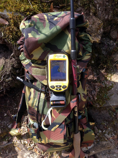
Everything I need to survive – water, food, first aid kit and
ArcGIS for Windows Mobile on a Trimble Juno

So how did everything work?  Pretty darned good.  In fact, better than I expected.  The simplified workflows in the ArcGIS for Windows Mobile interface make collecting data almost foolproof.  I only had a chance to capture about two miles of trail information and some points of interest, but it was enough to convince me this mobile GIS interface will work just fine for most of our user base.  Of course it’s an imperfect world, and so is this application.  I’d love the ability to collect photos while remaining in the GPS data streaming mode, and being the GPS geek that I am I’d like a better GPS performance interface (similar to what you get with ArcPad or Trimble’s TerraSync), but I also understand this package is designed for simplified data collection by non-GIS personnel, so I can live with the lack of GPS performance data.

Yellow SO clashes with my woods gear!

Of course all this simplification also serves as a straightjacket.  What you give up with the ArcGIS for Windows Mobile interface is the ability to make on-the-fly changes to your project – add new data types, change symbology, adjust GPS performance parameters, do complex searches, buffers, etc.  It’s a trade-off;  reduced complexity =  fewer options.  It’s a trade-off my organization can live with.

ArcGIS for Windows Mobile up close and personal.
A simple interface that works well on devices with small screens.

The REAL elephant in the room is the overall cost of this capability.  ArcGIS for Windows Mobile is an enterprise level solution for enterprise level projects.  As configured this project relies on an ArcGIS Online subscription account as the data hosting platform and ArcGIS Mobile deployment licenses tied to a very expensive ArcGIS enterprise license.  This equates to about $55,000 in licensing costs (toss in another $1,200 or so for the Trimble Juno).

Obviously this is not for the little guy.  But it should be, and it can be!  Let’s say you are a Geospatial geek like me.  Right now, today, if you participate in the ArcGIS for Home Use Program you get one free user license for  ArcGIS for Windows Mobile.  The software package includes a toolset that allows you to stage all your data on your local computer instead of on ArcGIS for Server or in the ArcGIS Online cloud.  You don’t get to wirelessly update your data – you have to connect the device to your computer via USB to do the synchronization process – but the rest of the workflows are the same.  A great (and cheap) way to test this capability for yourself.  You just have to go find a compatible Windows Mobile device (check eBay, there’s plenty for sale out there).

Looking into the future I see ESRI opening the ArcGIS Online subscription program up to market segments that don’t need and can’t afford to buy into the service at the current enterprise-like levels.  It’s almost an inevitability.  There’s a lot of emerging competition in the cloud GIS services arena, and companies leveraging some of the better Open Source GIS tools will start to provide low cost cloud hosting services in direct competition with ESRI.  Of course ESRI has the market share and clout, but the ‘cloud’ is a huge space, there’s a huge potential market, and ESRI can’t control it all.  Price competition will soon have its inevitable impact.  Plus, ESRI is pushing ‘the cloud’ like it’s the Second Coming and at some point they will realize their service availability will have to mesh with their message.  As they move more and more capability to the cloud ESRI will have to start offering low cost services for the little guy.

Maybe not this year, maybe not next year, but soon.

In the meantime use what’s available and get moving on Mobile!

Brian