Can Man Live By Chromebook Alone?

Recently I had to make a rushed trip to visit my Dad up in Ohio. I knew I was going to be there at least a week and that I’d have to get some work done. The dilemma I faced was that while Dad is tech savvy all he has available at his house these days is wi-fi and an iPad. Without realizing it, Dad has fully embraced ‘the cloud’. Once he got the iPad figured out he never looked back. It’s stuck to him like an appendage.

Faced with having to take some technology with me I was unsure just what I should bring. I don’t have a personal Windows laptop and the one my employer makes available is so tightly locked down it’s about as useful as a boat anchor in the Sahara. My Galaxy Tab S is a very capable tablet, but it doesn’t offer the kind of screen real estate I felt I’d need to get serious work done.

Thinking about it for a few minutes I realized that most of what I would need to do can be accessed via the web. I conduct just about all of my personal business via a browser interface these days – email, banking, managing my blog sites, etc. About the only thing I turn to a locally installed application for is ESRI’s heavyweight ArcGIS for Desktop environment and Microsoft Office, and if I need to do a remote desktop connection into one of our GIS servers I need to pull up the Windows RDC interface.

At work we are slowly but steadily moving much of our GIS environment to cloud-based services. We are heavy users of ArcGIS Online and are starting to dabble in Amazon Web Services. We are also trying to gently nudge our engineering staff over to some of AutoDesk’s web-based CAD tools like AutoCAD 360 and to web-based document management solutions.

In reviewing my requirements it became apparent that to get work done all I’d need is access to a web browser. The idea of a Chromebook running the Chrome OS (operating system) popped into my head. Actually, the idea had been residing there for some time. I just needed the excuse to go buy one.

Some background:

My wife’s school system moved off of the heavy iron IT model two years ago. They abandoned most of their Windows Server and Microsoft Office environment and moved to Google’s web-based education services environment. Escalating IT costs were putting an unsupportable strain on the school system budget. The move to Google services has been a godsend. Google charges a small annual fee for each account holder in the system (teachers, students and administrators all get their own accounts), they get access to the full suite of Google applications and services and Google manages the environment.

I serve as my wife’s shadow IT support for work related issues. In the old Windows Server/Windows XP/Windows 7 days life was hell. Something was always going wrong and I was always getting calls at work and making trips to her classroom to help troubleshoot hardware and software problems. Roberta is pretty darned tech savvy herself (at one point she served as a Windows NT desktop administrator at her old school in Germany), but she’s a classroom teacher, not an IT tech. She was simply overwhelmed by the number and complexity of the computer issues she faced. She needed to focus on teaching, not troubleshooting a crappy IT environment.

Since the school system moved to Google services the only IT-related trip I’ve had to make to her classroom was to make sure her printer was properly hooked up to her legacy Windows desktop.

The other thing her school has done is scrap the old Windows desktops and laptops in favor of lightweight (and cheap) Chromebooks. At first there was a lot of skepticism about whether a Chromebook could handle the computing needs of the average elementary school student. The school got a grant and bought a small test batch of HP Chromebooks. It turns out the Chromebook experience has been so good that the school is planning to expand it across all grades. The kids have taken to the Chromebooks like ducks to water, there is virtually zero admin overhead. Just open the Chromebook, log in and go! With the State of Georgia’s move to on-line standardized testing the ability to place an inexpensive, easy to use and easy to administer laptop on every student’s desk will become critical over the next few years. Chromebooks seem tailor made to meet that need.

So back to my requirements. It’s clear I’d already been thinking about a Chromebook for my own use, but I had the same concerns my wife’s school had – is the Chromebook capable enough to handle my temporary computing needs? The only way to find out was to take the plunge. The night before I headed up to Ohio I ran out to Best Buy and bought an HP Chromebook 14. This is one of the newer models with the Nvidia Tegra CPU, 2 gb of system memory, 16 gb of RAM and a 14″ HD display. My specific use and test goals included:

  • Overall hardware performance – system speed, storage capacity, wi-fi connectivity, external device connectivity, etc.
  • Managing my organization’s enterprise ArcGIS Online site
  • Managing my email and calendar from my organization’s Exchange server
  • Managing business related Microsoft Office documents
  • Managing my personal business needs – Gmail, my personal Microsoft Office 360 account, banking & finance, this blog, and more
  • Entertainment – watching Nexflix or YouTube videos
  • Stressing the system – can all of this be done with all tabs open at once in a single Chrome browser instance?

So how did it do? Overall I was fairly pleased with the whole Chromebook experience. I very clearly understand the strengths and weaknesses of a browser-based operating system so I didn’t try to do anything that the Chromebook can’t support, like trying to install Adobe Photoshop. The few weaknesses I uncovered were either hardware based or were easy to find work-arounds for. Let’s take a look at some of my observations.

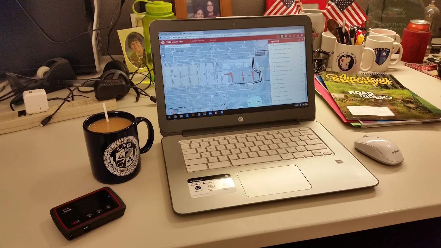
A Chromebook and a wi-fi hotspot (and a cup of coffee) make a great combination for getting some work done in ArcGIS Online

The Good

  • Chrome OS stability is very good. I had just one browser ‘freeze’ early on while I was setting up the system and Chrome was doing an update. Since then there have been no stability issues
  • The Microsoft One Drive and Office apps for Chrome are very well implemented. I’d heard that Microsoft put a lot of time and effort into building out these apps for both the Chrome and Android environments, and it shows. MS Office compatibility was one of my big concerns when going to the Chromebook, but my experience so far has been good. Now, I haven’t tried to open and edit a scientific paper with a lot of special formatting or tried to convert Tolstoy’s War and Peace from Russian to English using the Word translate function,but for the few lightweight documents I’ve created or edited it’s worked just fine
  • While the Chrome Web Store (similar to the Google Play Store for Android) seems to be well stocked with apps, keep in mind that many of these ‘apps’ are little more than shortcuts to web versions of certain products. I was pleased to find Microsoft Office and OneDrive apps – Word, Excel & PowerPoint that can tie directly back into my Microsoft Office 365 account.. Sorry, no Access. Skype seems to have been integrated into the Outlook app, but since I don’t use Outlook for personal business I didn’t get  a chance to test it.
  • ArcGIS Online management. I was pleased to find that managing my enterprise and personal ArcGIS Online environments was as easy on the Chromebook as it is sitting behind my GIS worstation back in the office. With one very minor exception – the uploading of thumbnail images to GIS service properties pages – the ArcGIS Online management experience is the same on this inexpensive Chromebook as it is on a $4,000 top-of-the-line desktop workstation
  • Video performance is first rate. Videos from YouTube and Netflix played smoothly with no dropped frames of audio issues

You may wonder why all the emphasis on Microsoft Office in the above comments. The reason is simple. While Google thinks its Google Docs suite will conquer the world the truth is that most of corporate America is still tightly wedded to Microsoft Office. For a Chromebook to be considered a serious replacement for a corporate laptop it must provide robust Microsoft Office compatibility.

Ohio River Town

What can you do in ArcGIS Online with a Chromebook? Build a Story Map! While in Ohio I visited some old favorite locations and built out this web map using ESRI’s Story Map template. The Chrome OS handles the ArcGIS Online interface just fine. You can click on the image to launch the map

The Not-So-Good

Most of the negative issues seem to be closely related to the HP hardware and it’s impact on the Chrome OS performance. Let’s have a look:

  • 2 gb of system memory is not enough. When more than four browser tabs are open performance starts to suffer. Even worse, there are some apps (Norton, the Ad Block app and others) that when installed will run in the background on every tab. These background apps absolutely kill system performance. My recommendation is to simply not add any of these to your Chromebook, but the long term solution is a Chromebook with more system memory. The next one I buy will have at least 4 gb of system memory
  • Why no delete key? Chromebooks don’t have Delete keys. Really? Like I never make mistakes and have to delete anything
  • Overall system performance is highly dependent on the quality and speed of your wi-fi connection. A lousy internet connection = a lousy Chromebook experience. Google touts that some Chrome OS features like Google Docs can be used off-line. My limited experience tells me that this an iffy proposition that highlights another hardware shortcoming…
  • 16 gb of RAM is too paltry. The system files take up almost half of that right off the top, leaving a pitiful 8 gb to store all of your off-line treasures. This situation can be mitigated somewhat by using a MicroSD memory card, assuming your Chromebook accepts one. The real answer is for manufacturers to bump up the system RAM to 32 gb

Neutral Observations

These are neither good points or bad points, just observations on software and hardware performance:

  • HP build quality is very good. Although the construction is all plastic the deice is sturdy and well put together. Battery life is also very good, offering slightly over 6 hours of continuous use
  • When the Chromebook is closed (but not shut off) battery drain appears to be reduced to near zero. It’s amazing that I can close this thing while it is still running and come back days later and there’s been almost zero battery drain
  • If the Chrome OS is secure from viruses and malware, as Google claims, why does Norton offer a Chrome-specific protection package?
  • No Google Earth. This highlights the key limitation of the Chrome OS. You can’t run installed applications on a Chromebook. As I mentioned above, the ‘apps’ you add to your Chromebook via the Chrome Web Store are little more than shortcuts to web sites that are highly configured to run in Chrome OS. You can’t install a stand-alone application in Chrome. Since Google Earth requires a ‘client side’ install this means no Google Earth on Chromebooks. So even Google can’t give you access to everything they offer
  • You can’t park icons or shortcuts on the ‘desktop’ because the ‘desktop’ isn’t really a ‘desktop’. It is just a holding space for the browser window to occupy. Old time Windows users will find this very frustrating. You can park shortcuts and icons on the taskbar at the bottom of the screen, but the rest of the ‘desktop’ is merely a vast, open and unused space until you open a Chrome browser
  • With the maturation of HTML5 and Java developers are pushing more and more functionality into the web browser, which places more demand on the ‘client side’ hardware. I wonder just how well Chrome OS will perform in the future, particularly on limited hardware, as developers bring more and more processing complexity into the browser technology
  • Personally I find this 14 inch Chromebook too big. Don’t get me wrong – it works great, but as a ‘grab ‘n go’ laptop it’s just too large. I’m keeping my eyes out for a 11 or 12 inch model with the right combination of processing power and battery life

So is the Chromebook a viable substitute for a full-up laptop? No. If you need to run installed applications (like ArcGIS for Desktop, or Adobe Photoshop, or even Google’s own Google Earth) or  then you will need to stick with Windows or MacOS. However, when working within the well understood limitations of the Chrome OS environment I found the experience pretty darned good. Let’s just say I’m a fan. In fact I’m already thinking about my next Chromebook purchase. A nice robust 12″ model with a fast processor, 4 gb of system memory and 32 gb of RAM and 8 hours of battery life. Price it under $300 and I’ll be in line to buy one!

– Brian

My Data Is More Accurate Because It Got Here First

Earlier this month Eric Gagstatter wrote a great little article for Geospatial Solutions Monthly titled “Nightmare on GIS Street: Accuracy, Datums, and Geospatial Data”.  Anybody who’s worked in the GIS field for more than a week has experienced the kind of issues Eric discusses.  Simply put, it is a rare event when data pulled from multiple sources fits together with any semblance of accuracy or precision.

For a small scale project (let’s say 1:20,000 or smaller) data fit is less important – at those smaller scales ‘eyeball close’ is often good enough.  The problem we face is that with modern GIS software the user is not stuck with a fixed scale like they were when everything was based on paper maps.  We live in the era of Google Earth, the era of high resolution satellite imagery, where everybody expects to be able to read the address number on their mailbox from space.  This new found ability to zoom to any scale with just the scroll of a mouse wheel has highlighted a problem that the general public and, to be frank, many Geospatial and civil engineering professionals, were not aware of: the data doesn’t fit.

Eric highlights the most important factor impacting this issue – the emergence of high precision GPS-based field data.  In the past 10 years or so GPS data, that data collected by survey grade or SBAS* augmented GPS units, has dramatically exposed the errors embedded in decades of historical geospatial data.

It’s not that this old data was collected badly – most of it was collected to established standards using the best resources and techniques available at the time.  In the old days it was paper maps, scaled aerial photos, compass headings, pace counts (or odometer readings for really long distances) and field notebooks.  Mapping grade accuracy was the accepted norm.  When you were using 1:24,000 USGS topo sheets as your project base an error of +/- 24 meters (the approximate National Map Accuracy Standard for those map sheets) was good enough.  Formal surveys were expensive and time consuming, and only done if there was a strong business justification – usually to establish legal boundary definitions, accurately map out small project areas, or precisely position critical features.

Today a Geospatial professional can collect data with handheld GPS units that easily achieves accuracies of +/- 15 feet with just SBAS augmentation, and centimeter level accuracies with survey-grade RTK (real time kinematic) equipment.  Accuracy has improved by several orders of magnitude and the cost of acquiring that data had dropped dramatically.

While Eric focuses on the issues of datums and datum transformations, my experience is a little different.  I work at a major airport that has terabytes of historical CAD data and a warehouse full of historical project plans on paper, mylar or linen that go back to the early 1940s.  Virtually all of this data is referenced to a local grid system that was first established as a construction grid back in 1948.  At the time this grid was established it was never formally defined in reference to the local State Plane coordinate system.  In fact, the surveyors who laid it out committed the cardinal sin of not establishing a central meridian that is oriented to true north.  The entire grid is rotated a few degrees off of true north and that angle of rotation was never defined when the grid was established.  For years this was not a problem.  The airport was happy to exist as an ‘island’, floating on the face of the earth within its own little grid system.  However, when the airport started to expand dramatically in the 1960s the engineers realized they needed to start tying into properly defined coordinate systems like State Plane.  USGS and USC&GS survey control was extended onto the airport and several monuments were defined in both the local grid system and State Plane.  This allowed project engineers and surveyors to ‘extend’ State Plane control onto their project sites if required, but all design and construction work was continued in the local grid system.  To this point all design work was done using old manual drafting methods, so the levels of error inherent in these processes were acceptable for the time.

In the 1980s CAD (computer aided design and drafting) systems started to be used on more and more projects at the airport. Since our local grid is a simple x,y grid based on distances in feet measured from an origin point it was easy to lay out in CAD.  No need to worry about that pesky rotation.  Or, for that matter, grid-to-ground mismatches over long distances (like say on a 9,000′ runway).  But very soon some serious folks with serious money, like the Federal government, began asking for airport data in a ‘real’ coordinate system like State Plane.  A number of attempts were made to try to define the local grid as a true spatial coordinate system (with a tie to a known coordinate system, an origin point and a rotation and scale factor) but with no success.  As a result some very sloppy work-arounds were developed, most using a ‘local fit’ method  – an engineer or CAD technician would snap local project data from one coordinate system to known good data in the other coordinate system; building corners, grid tics, manholes, whatever they could find.  The problem was that a lot of ‘known good’ data turned out to be not so good.  Errors propagated and started to become uncontrollable.  The engineering staff worked around this by referencing in local project data (for example, a new taxiway segment) against a small subset of the overall CAD basemap for the airport.  This method tended to keep the the coordinate system shift error within acceptable limits for the small project area, but when the data was added to the larger CAD basemap grid shift errors of up to 15′ were common.

When my Geospatial group came on board in 2007 the coordinate system transformation issue quickly became one of our biggest headaches.  We were faced with creating an enterprise geospatial database from scratch using this legacy CAD data.  We desperately needed a proper spatial definition for this local grid system, something that would work in both our CAD and GIS systems.  Our engineering staff was happy to dump the issue in our lap.  In fact, when I interviewed for the job one of the senior engineers told me that if I was hired the first thing he wanted me to do was to “fix this damned State Plane thing.”

As we started talking with the engineering staff about the problem it became apparent they all had an institutional distrust of State Plane, or any spatial coordinate system for that matter.  They placed the entire blame for the data fit issues on ‘inaccuracies’ in the State Plane system – inaccuracies they couldn’t articulate.  In their minds all data prepared in their local grid system was golden.  After all, the local grid system was known.  It was proven.  It was simple.  They had built an entire world-class airport on it.  This goofy State Plane thing just got everybody confused and besides, when they did move their CAD data to State Plane it ‘got shifted all around’ and didn’t work anymore.  It might fit OK at one corner of the airport, but didn’t fit too well at the other.

We eventually got the grid transformation issue solved.  We attacked it from several directions and ended up with a very accurate local grid system projection file for use in both AutoCAD and ArcGIS, and a best-fit definition for use in Blue Marble (for bulk coordinate point conversions).  All of these definitions are based on the same survey data so errors are consistent and controllable from system to system.  We can hold transformation errors to about 0.2′ across the airport property.  And yet our engineering staff still retained a latent distrust of State Plane-based data.  The old institutional bias remained.  The perception that ran deep is that the old ‘known’ CAD data in the local coordinate system is somehow better, more accurate, than any newly collected GIS data.  There is a natural distrust of geospatial data; few civil engineers understand what geospatial data is, how it differs from CAD data and how geospatial data can be incorporated into planning and design projects.  If the data file doesn’t have a .dwg at the end of it they don’t like it.

We decided to approach the perception issue from two directions.  The first was a current high resolution, high accuracy orthophoto of the airport.  Using our newly developed projection file we were able to reproject the aerial from State Plane to the local grid system for use in AutoCAD.  For the first time ever the engineers and CAD staff had a single continuous coverage aerial image in their grid system that could be used as a base for project planning and drawing development.  Next, we acquired RTK-based data collectors that are capable of centimeter level accuracy.  We launched on an aggressive project to collect photo identifiable data – manholes, paint markings, slab joints, airfield lights – and provide the data in both grid systems as a tool to check current and historical data against.  From this we created a ‘trusted’ CAD file,  one the engineering group verified using their own sources.  Ever so slowly some of the doubters started to come around.  Once they started matching their legacy data against these new sources and saw the problems for themselves they began to do more aggressive data checks and not take CAD data, old or new, at face value.

Yet we continued to have perception problems.  The old-line engineering staff retained a deeply embedded distrust of GIS data in State Plane and our insistence that all legacy data to be closely checked and adjusted if necessary.  Their reasoning actually sounded pretty good – “We spent decades building a world class airport with this CAD data and it all came together.  How can the data be wrong?”

Our GIS group didn’t really have a good response until some of the long time CAD staff complained that “it’s impossible to get as-builts around here.”  Our antennae went up and we started to do some digging on the issue.  Very quickly the problem revealed itself.  Our engineering staff rarely received true as-builts from the contractors that do construction on the airport.  The as-built delivery requirement is written into most contracts but is rarely enforced.  Contractors would regularly walk away from the as-built requirement and eat the contract penalty because they were too busy on other airport projects or the cost of developing the as-builts exceeded the monetary penalty.  If a contractor did deliver what they labeled as ‘as-built’ drawings they were seldom, if ever, checked for accuracy and completeness by the project manager.  The data was accepted at face value and often recycled for use on the next project.  Errors in spatial accuracy or attributes (pipe sizes, slab thicknesses, etc.) were unknowingly propagated from project to project as the project planners and designers used the same inaccurate data over and over again.  Down the line some errors became so glaringly obvious (like a stormwater line flowing uphill) that the engineering staff would hire engineering firms to go to the field and conduct existing condition surveys.  It was not unusual for the airport to hire the same firm that originally delivered the bad data to go back out and field verify what they should have originally delivered years before in the project as-builts!

But this only addresses half of the question.  The fact remains that this airport got built, and got built pretty darned well.  Was it all built on sloppy CAD data and it’s just a happy accident that everything fits?  Well, once we understood the as-built issue the rest of the story fell into place.  The engineering staff at this airport only does planning and initial design.  The final design work and construction drawings are done by contracted engineering firms.  Construction drawings are based on a number of sources – initial design, existing condition surveys and final design plans.  Construction drawings are what the project engineers and tradesmen take to the field to actually build against  These are the drawings that get marked up as modifications are done in the field and it’s these drawings that should be used to generate the as-builts.  These engineering firms do a very good job of making sure everything fits within the designated project space, and any ties to existing systems – utility lines, roadways, buildings, etc. – are adjusted for in the final design or in the field.  But we are back to the old as-built issue.  Much of what was actually constructed in the field never makes it back into the airport’s master CAD drawing.

So the reality is that the airport got built, but the airport doesn’t have a complete and accurate record of what got built.

But I do get the sense that we are over the hump.  In the last two years we’ve noticed an improvement in the consistency of the spatial accuracy of the CAD data being delivered.  We still find a good number of attribute data issues (stormwater manholes labeled as sewer manholes, that sort of thing), but as far as spatial accuracy things seem to be greatly improved.  I put it down to our engineering staff’s increased use of known good data as a quality control check, increased emphasis on as-built delivery, a willingness to let us be part of the quality control check process, increased dialog between the CAD and GIS analysts and an increased dependence on our RTK data collectors to do quick field verification.  In fact, our engineering staff is now the #1 hands-on  user of our RTK systems.  The GIS group also has tight relationships with many of the major construction contractors doing work at the airport and we provide the coordinate system definition files and verified base data for use in project planning.  We also offer ourselves up as the data conversion experts and will help contractors verify that their data has been properly moved from one grid system to the other.  Over time our insistence on spatial accuracy has ‘leaked into’ the engineering business processes and workflows here at the airport.

We’ve shifted the paradigm just a bit and the momentum is in our favor.  Geospatial engineering 1, bad data 0.  That’s the way it should be.

Brian

*SBAS = Space Based Augmentation System.  There are several SBAS systems in use around the world.  These are satellites in geosynchronous orbit that transmit correction data for the US GPS satellite constellation.  The Wide Area Augmentation System (WAAS) is a set of satellites transmitting correction data over the US and the eastern Pacific and is maintained by the FAA and DOT.  If your GPS unit can receive and use these signals they will roughly double the accuracy of the position fix your unit provides.  You can read more about WAAS and SBAS on Wikipedia.

GPS – It’s Not Just For Geocachers!

OK folks, let’s put on our big boy pants and play grownup GPS.

“Look at me!  I know how to use GPS for
something other than geocaching!”
I’m involved in a test at a very large and very busy airport to determine the feasibility of using inexpensive handheld GPS receivers as reconnaissance tools for our engineering and facilities staff.  The consumer market is crammed with relatively inexpensive GPS devices and any one of those should fit the need.  We are not necessarily looking for accuracy here; most dedicated GPS units made these days offer plenty enough accuracy.  More important for our project is ease of use, the ability to import a fairly high resolution background image of the airport and the ability to provide coordinate read-outs in our proprietary (i.e., non-standard) grid system.
Let’s start with the proprietary grid system issue.  It may sound daunting, but it’s really not.  A fair number of low end GPS units provide what’s called a ‘user coordinate system’ setting.  The user just needs to provide a center point for the grid (in lat/long), a false northing and easting for the center point, a scale factor and few other bits of information.  It’s pretty straight forward, and we’ve been able to program a 13 year old Magellan 315 to handle the task.  The Magellan 315 was a hot-spit GPS unit in its day but by today’s standards it is out dated.  It is relatively slow to boot up, slow to acquire and lock onto satellites and it doesn’t receive WAAS signals.  Still, it is easy to operate, the screen is a classic example of uncluttered high contrast clarity and it takes user coordinate system definitions without breaking a sweat.  Once it was up and operating it provided perfectly acceptable accuracies.
Magellan 315
Simple to operate and
has no issues with operating under
a proprietary grid system
Next we tested a seven year old Thales Mobile Mapper.  The Mobile Mapper was a piece of kit left behind at the close of a project several years back.  The contractor bought it to help locate underground utility marker balls and turned it over to the airport when the contract ended.  It’s an odd duck piece of gear – not friendly enough to take on a fishing trip but not sophisticated enough to satisfy surveyors.  Still, it was perfectly willing to accept our coordinate system definition and returned fine accuracies.
Thales Mobile Mapper
So we proved it’s possible to program our coordinate system into inexpensive GPS units.  It should be a simple task to identify a more modern unit that fit our performance and budget requirements.  This is where things got interesting and frustrating.  Our quest has revealed an ignored market segment for GPS units and leaves us scratching our heads and wondering just where the consumer GPS market is heading.

____________________________________________________________
GPS is marvelous technology.  It has removed the great uncertainty in wayfinding and positioning that has vexed mankind since the first caveman decided to go from here to there and his wife told him where to turn.  The real genius of GPS has been in the integration of the location signal (and that’s all GPS really is – a bunch of signals from satellites in the sky that provide the information a GPS receiver needs to calculate a position) into devices that leverage that location in unique ways.
Twenty years ago a ‘consumer grade’ GPS was an expensive piece of gear that did little more than provide a location and allowed you to store a few dozen waypoints.  In 1999 I purchased the Magellan 315 used in this test for $300, and was happy to get it at that price.  Today $300 buys a unit that provides a position fix that is twice a precise as the 315, uses a high resolution color touchscreen display, stores thousands of waypoints, has a digital 3-axis compass, a barometric altimeter and a digital camera that takes geotagged images.
But the success of the integration of dedicated GPS receivers is also proving to be their undoing.  Here’s why.  I can walk into just about any AT&T, Verizon, T-Mobile, Wal-Mart, Target or Best Buy and purchase a smartphone that offers these same features for about $200 (if I sign up for a service plan).  But in the package I also get a phone, a messaging device, a video chat device, an internet device, a music player, a game console and much more.  The integration of GPS into common consumer devices like phones and tablets is killing the dedicated GPS industry. It’s not that highly integrated devices like the iPhone are better GPS devices – far from it.  The real problem is perception.  When pondering the purchase of a dedicated GPS unit the average consumer glances at his or her smartphone and asks, “why spend another couple of hundred bucks when I already have GPS and a mapping application rolled up into this device?”

Most consumers are not educated enough to understand that a dedicated GPS unit offers features that make it uniquely suited to outdoor use in rugged environments.  GPS integration in a smartphone is a compromise, particularly the antenna system.  On a smartphone GPS has to coexist with a range of other receivers and transmitters that all require their own antennas – cell, wi-fi, Bluetooth, etc.  A smartphone is first a phone, and other features like GPS get secondary design consideration.  But with a dedicated GPS unit optimized GPS reception and performance is the primary design goal.  First and foremost we expect a GPS unit to provide fast and accurate position fixes under a wide range of conditions.  If you want to know where to find the nearest Starbucks get a smartphone.  If you are on a seven day backpacking trip and its been raining the last three days and you want to know where the next campsite with a bear box is located get a dedicated GPS.

So let’s take a closer look at how the market is broken down.

Today’s dedicated GPS devices fall into three broad categories.
1. Consumer grade devices like we are discussing here.  This market is focused mainly on those participating in outdoor sports like geocaching, hiking, biking, fishing, etc.  These devices cost between $200 and $700, with the bulk of sales taking place at around the $300 price point.  This is the market segment that receives brutal competition from other consumer devices like smart phones, and the manufacturers are scrambling to find a niche and stay relevant.  Garmin, Magellan and DeLorme are the three leaders here.
The Garmin eTrex is perhaps the most
successful line of consumer GPS units in the industry
2. Dedicated map data or field data collection devices.  These are handheld units running mapping software like ESRI’s ArcPad and are used by organizations like utility companies to collect information in the field.  These mapping devices have an entry price point of around $1,000 and can go up to over $3,000.  Most of these units offer more GPS accuracy through the use of improved antennas and better software, but offer fewer features like digital compasses and altimeters.  The big attraction with these GPS units is the flexibility of the mapping software and the ability to directly ingest the collected data into high end desktop mapping software like ESRI’s ArcGIS suite.  The additional cost for these dedicated GPS units is the result of a smaller market share, higher hardware costs and the increased cost of the the operating system (usually Windows Mobile) and the mapping software.  Trimble Navigation dominates in this market.
Trimble Juno
No compass, no altimeter but hey,
at least it runs Windows!

3. The high end market is dominated by survey-grade GPS units that start around $5,000 and can peak out at over $30,000.  For that price (along with a subscription to a real-time correction service that runs a few thousand each year) the user gets accuracies on the order of a few centimeters horizontally and vertically while working on-the-fly.  Not for the casual user, but it is interesting to note just how much accuracy thirty grand can buy.

A GPS-based surveying system.  This unit is capable of accuracies
of +/- 4 cm within 5 seconds of being placed over a point.
How big is 4 cm?  About the size of a poker chip.
Not for the faint of heart, though.  The saucer-shaped thing at the
top of the pole (Trimble R8) is the high accuracy
GPS receiver and it alone costs about $8,000
____________________________________________________________
OK, back to our original topic.
The goal is to find a GPS receiver that:
a. comes in at around the $250 – $300 price point
b. can use our custom coordinate system
c. can use a high resolution aerial imagery as a background map
d. is easy to use – should be almost a ‘grab-n-go’ device
e. collects simple data points, lines or polygons in a format we can easily bring in to our GIS and CAD systems

We selected a fair number of units to test – the Magellan 315 and Thales MobileMapper mentioned earlier, a Trimble Juno and Yuma, a Magellan eXplorist 610, a DeLorme PN-60 and a Garmin eTrex 20.

Top – Trimble Yuma
Middle – DeLorme PN-60, Thales MobileMapper, Magellan 315
Bottom – Magellan eXplorist 610, Trimble Juno, Trimble TSC-2

The DeLorme and the eTrex quickly fell out of the competition.  The DeLorme does not support user coordinate systems (a very disappointing shortcoming in an otherwise outstanding GPS unit).  The eTrex does have a user coordinate system setting, but it only works in meters (our custom airport coordinate system is set up in feet).  I was really pulling for the eTrex 20 because it’s the cheapest of our test samples ($175 Amazon price), has a good screen, an intuitive menu system and its receiver tracks both the US GPS and the Russian GLONASS satellites.  Alas, Garmin tech support could never figure out how to get it to provide readouts in feet so back to the store it went.

The Trimble Yuma is really a tablet computer running Windows 7.  It is a very capable device, but at the $5,000 price point falls way outside of our test objectives.

The Trimble Juno is an interesting unit.  It is essentially a highly customized PDA that runs Windows Mobile 6.1.  This Juno is really the lowest entry point in terms of price and features for a serious handheld GPS mapping and field data collection device.  Unfortunately the entry price is still too steep for this test – the hardware itself costs around $1,000 and the software needed to do field reconnaissance and data collection – ESRI’s ArcPad – runs an additional $400.  A good device, just too expensive and too complex for the non-technical user.

The Trimble TSC-2 seen in the picture above is not really a GPS receiver.  It is a survey-grade data collector that pairs with a high precision GPS receiver via Bluetooth (we use a Trimble R8) .  I threw it into the picture just for comparison.

The Magellan 610 pulled ahead early in the competition.  It’s a mid-sized unit that’s a bit chunky but fits well in the hand.  It uses a touch screen interface and it includes a 3.2 mp camera that geotags each image.  After some fiddling it took our custom coordinate system and returns very good accuracies on the order of +/- 10 ft.   I should mention that a large airport is an ideal location to test potential GPS accuracy since you have open skies horizon-to-horizon.  If the GPS satellite is above the horizon your receiver will see it.  No trees, buildings, towers, etc. in the way.  So please, don’t take my accuracy results as gospel.  Your real world results will vary.

Magellan eXplorist 610
A very capable little device

Where the Magellan 610 stumbles is ease of use.  It has a lot of features – GPS, camera, compass, barometer and altimeter.  It is a jack of all trades and, to be honest, most features are fairly well integrated.  However, learning to use them takes time and it’s easy to get lost in the touchscreen menu system.  The Magellan also suffers from a disease that afflicts most other consumer grade handheld GPS units – ‘gamesmanship’.  In an effort to attract new customers manufacturers like Magellan, Garmin and DeLorme have built their user interfaces around the game or sport of geocaching.  It’s a fun game and a great way to get tech savvy kids off their asses and into the outdoors.  The low end GPS manufacturers see this as a market niche they can exploit and have structured most of their unit’s features around geocaching.

The problem we face is that geocaching-oriented GPS units makes lousy general purpose or field data collection units.  By focusing on geocaching the manufacturers have ignored the needs of a whole different market segment – the map data developer.

A weak coordinate system library, the lack of a GIS-industry standard vector data format such as the ESRI shapefile, weak data attribution tools on the GPS unit and a weak desktop mapping interface all hinder the use of these units as data collectors.  DeLorme comes the closest with it’s XMap desktop GIS software, but the cost is over $800 per license it continues to use a proprietary vector data format linked back to the PN-series receivers.

What the industry needs is a low-end map data collector that has a simplified interface optimized for adding and attributing data collected in the field.  It needs to use industry standard vector and raster data formats and should come with a more robust desktop mapping interface oriented towards the field mapping industry or enthusiast.  Magellan seems to be dipping its big toe back into this market with the Magellan eXplorist Pro 10, but this device still requires a third party software package like ArcPad and offers no improved desktop mapping software.

Magellan eXplorist Pro 10
This is just a re-packaged Magellan 610, but a good start!

So GIS industry wonks, here’s what I want:

1. a handheld GPS unit with a large, high resolution screen that is easy to read in broad daylight

2. consumer-grade accuracy using WAAS correction

3. a user interface highly optimized for field data collection – no third party software requirements!

4. a robust horizontal and vertical coordinate system library and the ability to accurately define a user coordinate system

5. a 5 megapixel digital camera with flash

6. the ability to configure field collection jobs or scenarios and save them as project files

7. twelve hour continuous use battery life

8. an external antenna port

9. fully waterproof

10. improved desktop software for device configuration and data download and upload

11. use of industry standard vector and raster data formats

And I want this all at a $700 retail price point.

So get to work.  I expect some nice surprises in your 2013 lineups!

– Brian