Patton Shoots an Azimuth

In 1942 George S. Patton was one of the fast rising stars in the US Army. In less than two years he had leapt from the rank of colonel to major general and went from commander of an armored brigade to commanding the 1st Armored Corps and the newly formed Desert Training Center in southern California (now known as Fort Irwin and the National Training Center). The 1938 – 1942 period was a time of explosive development and innovation in the US Army. War was on the horizon and our national leaders accepted the fact that America would be involved. There was a mad scramble to get our military the personnel, money and equipment needed to get ready for the inevitable. After almost two decades of neglect the US Army suddenly found itself flush with cash and manpower, and new equipment was coming on-line every day. Experienced officers who were innovative thinkers found themselves skyrocketing up the ranks as the new Chief of Staff of the Army, George C. Marshall rushed to fill the newly created command slots

Patton was a natural pick for Marshall. They were contemporaries and both had made a name for themselves during WWI. Patton had commanded the Army’s only armored forces during the war and was a full throated advocate for they type of fast moving mechanized warfare that would be needed on the battlefields of Europe. Between the wars Patton wrote extensively on mobile warfare for the Army’s professional journals and many of his ideas found their way into the Army’s doctrinal manuals. So in 1941 when General Marshall needed a tough, experienced officer to take over training for the Army’s newly formed armored forces he looked no further than George S. Patton.

Patton was given command of the 1st Armored Corps and told to find land suitable for training large mechanized forces. A Southern California native, Patton knew the large empty desert tracts east of Palm Springs was the perfect location. He established the Desert Training Center (now known as Fort Irwin and the National Training Center), moved his headquarters there and began the task of getting the Army’s armored units ready to beat the German army at their own game.

But what good is a highly trained, well equipped armored force if they don’t know where to go? Well, during this same 1939 – 1942 time period there was an effort going on with the Army Corps of Engineers and the Infantry School to standardize map production, adopt a new type of compass and develop innovative map reading and land navigation training programs for the entire Army. One of the results of this effort was the development of the M1938 lensatic compass. We know Patton was keenly interested in land navigation. He regularly used National Geographic and Michelin road maps during maneuvers and was often heard complaining about the shortage of standard military maps his armored forces needed to navigate across the battlefield.

The Army would have shipped the newly adopted M1938 compass to the Desert Training Center for testing and evaluation, and one of these compasses would have made it into Patton’s hands. Patton was a detail man and took a keen interest in everything his Soldiers were issued. He considered it part of his leadership responsibility to make sure a Soldier’s equipment worked. It makes perfect sense that Patton would have gotten his hands on one of these new compasses and put it through its paces.

Sometime in early 1942 a photographer asked General Patton to strike a pose doing something dramatic. I don’t know who’s idea it was to have him pull out his compass and shoot an azimuth to a distant point, but the resulting photo is interesting. Patton is standing beside his early M3 Stuart command tank and decked out in full battle regalia – tanker helmet and goggles, tanker jacket, binoculars, signature pistol at his side and an M1938 compass in his hands.

Patton With Compass

Just a few months after this photo was taken Patton would be pulled from his assignment as commander of the 1st Armored Corps and placed in command of the Western Task Force for the Allied invasion of North Africa. It’s at this point the common legend of General Patton begins, but we should always remember that he was instrumental in developing much of the Army’s early armored warfare doctrine and pushed hard for improved maps and map reading skills.

An Unusual Ainsworth Compass

A few months back I picked up an unusual William Ainsworth & Sons surveying compass that closely resembles an Ainsworth-produced Brunton Pocket Transit.  The resemblance is so close, in fact, that the lid of the compass is even marked ‘D. W. Brunton’s’.  There’s no doubt that this is an original Ainsworth instrument (as opposed to a copy or knock-off), but it certainly isn’t a pocket transit.

BruntonSurvey1

 From the outside it looks like a common pre-WWII pocket transit

So what do we have here? Well, it appears to be a survey compass built using a pocket transit case.  I’ve never seen or read about an instrument of this type, so I assume it’s fairly rare.

BruntonSurvey2

However, inside we see something quite unusual. It’s not a pocket transit but a surveyors compass!

Two key questions are, when was it made, and for whom?  Based on the case design and markings this is instrument was made after 1914, and we can be sure of that based on the ‘figure 8’ peep sight design which was patented by D. W. Brunton in 1914. But going a bit further, I’ll also wager that this instrument was built post-1927 when Ainsworth acquired the manufacturing rights to the Brunton pocket transit from D. W. Brunton’s estate.  This would account for the use of the pocket transit case and a lid that carries all the Brunton patent data on a device that is clearly not a pocket transit.  I doubt Mr.Brunton would have allowed his name and patent information to be used on something that was not of his design.

William Ainsworth & Sons was a well known instrument maker and produced high end instruments for the mining, geological exploration and surveying industries. The idea that they would consider using a pocket transit case to produce a small survey compass is not at all far-fetched. In fact, it makes perfect sense. The cases were already in production, the pocket transit was a well known and highly regarded design and it would have been easy to simplify the housing design to contain just a compass needle. In theory it would also have been cheaper to build since the bubble levels, clinometer arm, scales and external clinometer lever are all left out of the design.

BruntonSurvey4

This compass leaves out the standard pocket transit bubble levels, clinometer arm and scales. It also uses a type of bar compass needle commonly found on surveyors compasses but never seen before on an Ainsworth pocket transit from this era

But was this an attempt to bring a simpler and cheaper pocket instrument to market or was this made to answer a product requirement submitted by a customer? We may never know, and there aren’t enough clues we can glean from the instrument itself to make a good guess. This particular instrument is painted in a dark green, very similar to Army olive drab. The paint job is well executed and was probably done at the factory. It’s also stamped with the serial number ‘1042’, but the serial number placement, text size and style are not what we’re used to seeing on other Ainsworth instruments. This indicated it may be part of a special production run for a large customer – perhaps the US military or another federal agency such as the USGS or the US Forest Service.

Another interesting design feature relates to how the compass is mounted to a tripod. Pocket transits are secured to tripods using a ‘U’ shaped bracket the slides into grooves machined into the side of the transit case. This compass design takes a more common approach, and one used by most surveyor compass manufacturers. That is, the mounting thimble or bracket screws into the base of the instrument. Pocket transits can’t use this arrangement because of the clinometer lever that extends through the bottom of the case. But since this compass doesn’t have a clinometer Ainsworth was free to use the more conventional mounting method.

BruntonSurvey5

 The compass mounting thimble screws directly into the base of the compass. A common arrangement with surveyors compasses, but not seen with pocket transits

 BruntonSurvey6

This view shows the mounting socket at the base of the compass

So there we have it. An interesting instrument that represents the adaptation of the popular pocket transit design for another purpose.

If any of my readers have any additional information on this instrument I’d love to hear from you. Please just leave your comments on the blog for all to see. Thanks!

– Brian

History Revealed! Origins Of The Army Lensatic Compass

For several years I’ve been trying to piece together the history of the US Army’s lensatic compass.  In an earlier post on this blog we discussed the various types of compasses and a bit of the developmental history that can be inferred by viewing the examples in my collection.  However, there was (and still is) very little solid history on the development of the lensatic compass available on the web.

For an item as ubiquitous as this compass the lack of historical data seems a odd.  The development and usage histories of many other items of WWII-era equipment are well documented.  Take the M1 Garand for example.  Collectors can discuss in detail every single part on that rifle and can accurately date and discern the manufacturer of each part by noting subtle differences in how the piece was machined or finished.  This wealth of knowledge is due to the fact that the development and production records for the Garand were made available decades ago by the US military and the various manufacturers.  Of course collector interest is also a factor.  The Garand is one of the most collected pieces of WWII equipment and when you have thousands of collectors clamoring for detailed information the odds are pretty good someone is going to unearth the data.  Since there can’t be more than a dozen serious collectors of Army lensatic compasses there’s a whole lot less clamoring.

As an item of individual equipment that guided millions of Soldiers across the battlefields of Europe and the Pacific in WWII, and continues in use by our Soldiers today, I’ve always felt the history of the lensatic compass deserved better coverage.

Earlier this week I was on a different quest.  I recently purchased an interesting bit of Army topographic kit, a Vertical Sketchmaster (I’ll do a posting on that later).  Since the device came without paperwork or documentation the first thing I did was hit Google for a quick search.

[A short segue here.  Hey Google, your search results are starting to look like those from the half dozen or so search engines that have all but fallen off the internet.  When I do a search on your site I’m looking for real results, not page after page of ads or eBay listings.  Any more, searching on Google is like searching on – dare I say it – Yahoo!]

Buried about three pages deep in the search results was a reference to a holding in the Defense Technical Information Center (DTIC) titled “History of [the] U.S. Army Topographic Laboratories (1920 to 1973)”.

The phrase “Army Engineer Topographic Laboratories” got my immediate attention because the document could only be referring to what used to be know as the Army Corps of Engineers’ Engineer Topographic Laboratories, or ETL.  ETL and it’s predecessor organizations within the Corps of Engineers served (and still serve) as the Army’s R&D lab for development of topographic, terrain analysis and geospatial systems, processes and equipment.  Now called the Army Geospatial Center, it was an organization I called on many times during my career for support and advice, and they always came through.

As luck would have it the document is available in digital form through Google.  I immediately downloaded it and started reading.  Published in 1973 as an ETL internal paper by John Pennington, it is a short rundown of the history of the Army’s topographic R&D labs and covers major projects and equipment development between 1920 and 1970.  I don’t want to spend too much time on this document in this post, because I feel it deserves it’s own separate discussion at a later date.  For now I’ll just say it is a treasure trove of historical information.

While reviewing the document for information on the vertical sketchmaster I quickly came across discussion of lensatic compasses.  This was something completely unexpected.  I never considered that the development of the lensatic compass was something an Engineer topographic R&D lab would have been involved with.  After reading the entries it now makes perfect sense – the Engineers had doctrinal responsibility for development of land navigation equipment and were the Army’s subject matter experts on compasses of all types.  While the development of land navigation techniques including the use of map and compass was the responsibility of the Infantry School, development of the compass as an item of equipment was the responsibility of the Engineers.  Of course the two branches worked hand-in-hand on the project, with the Engineers serving as a test and development agency in support of the Infantry School.

The document briefly discusses compass development both prior to and after WWII and adds some fascinating tidbits to the history of the development the lensatic compass:

Since the quality of the scan is pretty poor I’ve reproduced the key parts below:

(7)  Compasses.  Although the compass is not strictly a surveying instrument, considerable effort was expended by the Mapping Branch of the Engineer Board in the World War II period on the development of small compasses for Infantry and other arms.


The work started in 1938 when the Infantry requested that an inexpensive, commercial-type compass be found to replace the marching compass then issued because the marching compass was too large, elaborate, and costly.  This investigation was assigned to the Engineer Board, and it was soon found that no suitable commercial compass was available.  The W. & L.E. Gurley and the Taylor Instrument Companies, however, were willing to make a suitable compass based on a new design; and each company made six samples in 1939 as ordered from the Engineer Board.


After testing by both the Infantry and Cavalry and some modifications by the manufacturers, in November 1940 the Engineer Board recommended procurement of the cheap lensatic compass from both manufacturers.”


Thus we have the WWII-era M1938 lensatic compass.

M1938 Lensatic Compass
My question now is, was this originally a liquid filled model?  Read below.

One interesting point is that while lensatic compasses made by Gurley are fairly common (they were a major manufacturer of surveying equipment at the time) I have never seen a military lensatic compass made by Taylor Instruments.  However, Taylor Instruments did go on to be a major manufacturer of wrist compasses for the US military in WWII.

But the story is not over.  Even back in 1940 they were struggling with the issue of how to dampen the compass needle or card.

“Since the mechanical dampening arrangements in all compasses available up to that time had not been entirely satisfactory, the Engineer Board started investigations of liquid dampening in December 1941.  Compasses of both the lensatic and the wrist type with liquid dampening were developed, tested, and adopted in the 1941 to 1944 period; and it was thought for a time that the compass problem had been solved.  However, it was discovered that, with temperature changes, an air bubble often developed in the compass capsule which impeded the free movement of the compass needle and affected the accuracy.


In July 1944, the Superior Magneto Corporation, one of the liquid-filled compass suppliers, solved the liquid  dampening problem by applying the induction dampening principle.  The compass body was made of copper which set up an eddy current and magnetic field as the compass needle rotated, thus acting as a drag to dampen the needle oscillation.  Samples were immediately procured and tested.  As a result, the induction dampened wrist compass was standardized in April 1945, and the induction dampened lensatic compass was standardized in May 1945.”


Based on the number of WWII compasses available for sale from auction sites like eBay I think that Superior Magneto was the #1 supplier of lensatic compasses during WWII.  Knowing their core business – the production of magnetos – it makes sense that their engineers would have a clear understanding of the principle of induction and how to apply it to the problem of compass needle dampening.

Today M1938 compasses with induction dampening are easy to identify.  They have a white compass bowl that contains the compass card.  The white bowl is the stamped copper cup that the compass magnet interacts with to slow oscillation.  It is an excellent dampening system and is still used today in US military-issue lensatic compasses.

M1938 Lensatic Compass with induction dampening.
Note the white compass bowl.  This is really a stamped copper cup that interacts
with the north-seeking magnet to reduce oscillation of the compass card.

Let’s skip forward now to the late 1940s, when it was clear that the lensatic compass was in need of an upgrade.

(3)  Compasses.  The development of compasses, both the wrist and the lensatic types, was reopened in 1947 to provide instruments which would overcome the deficiencies noted in those developed during World War II.  Experimental models of the lensatic compass were produced by Taylor Instrument Company, Rochester, New York (Fig. 84), and the Brunson Instrument Company, Kansas City, Missouri.  Both were found to conform to the military characteristics, but the Brunson model was considered superior.  Experimental models of the wrist compass were produced by the Brunson Instrument Company, Kansas City, Missouri (Fig. 85), and were delivered to ERDL in January 1950.  Cold weather tests of the lensatic compass were conducted at Fort Churchill, Canada, and in January 1951 service test models were procured and shipped to service test agencies.  Here again, as with the compass development during World War II, emergency procurement of large quantities of both compasses were made before all testing and development had been completed.


Development of both compasses was completed in 1952.  The lensatic compass was classified as standard type, and the project was closed in November 1952.”


The result of these tests and type classification are the classic M1950 Lensatic Compass, a design still in use today:

M1950 Lensatic Compass produced in 2010 by Cammenga.
Today Cammenga is the sole contractor producing lensatic compasses
for the US military.

The M1950 is still one of the best compasses ever developed, and I consider it the best military compass ever issued to any military anywhere in the world.

The Wilderness Route Finder

I grew up reading – devouring, really – the works of two great outdoor writers.  One was Brad Angier and the other was Calvin Rutstrum.  These two adventurers had been living the ‘back to nature’ lifestyle long before the backpacking craze hit America in the 1960s.  Both were prolific writers, turning out books and papers that extolled the wilderness lifestyle.  Angier’s works were more philosophic – he fancied himself a modern day Thoreau and his books reflected that outlook.  Rutstrum, on the other hand, didn’t just live the wilderness lifestyle, he actually worked in and made a living from the wilderness, primarily through guiding.  Rutstrum’s advice was always more down to earth, more practical.

Some of Rutstrum’s advice would cause modern day enviroweenies to fall over in a dead faint. For example, to deal with the biting insects that invariably got into your tent when camping in the north country Rutstrum recommended just tossing a DDT ‘bomb’ (spray canister) into the tent, zipping it up and letting the insecticide do its job.  Go off and do your chores and when you come back you’ll have a bug-free tent to sleep peacefully in.  Keep in mind, however, that Rustrum’s books were written from the late 1940s through the 1970s, so some procedures and ‘best practices’ are now out-dated and in many cases downright illegal.  Regardless, his books like ‘New Way of the Wilderness’ and ‘Paradise Below Zero’ are still considered classics of outdoor literature.

Another gem that Rutstrum wrote is ‘The Wilderness Route Finder’.

My copy, purchased in the late1970s and well
thumbed

I first came across this book over 30 years ago and read it cover to cover multiple times.  I believe it is the first broad application land navigation work written for the general public.  (The Army land navigation field manual, FM 21-26, pre-dates this work by several decades.  While an excellent work is targeted at military users.)  Rutstrum approached land navigation the way he approached so many things related to the outdoors – use what works.  He presents a broad range of techniques and discusses use of a number of pieces of equipment  that can assist in navigating the high latitudes where the magnetic compass becomes unreliable due to declination issues and local magnetism.

Obviously this book was written before GPS was even a gleam in the eye of senior military commanders, and many of the pieces of equipment Rutstrum discusses are out dated or simply not available anymore.  For example, cruiser compasses have not been made for decades and have now entered the status of collector’s item.  However, some of the techniques he discusses, while at first glance seemingly archaic in the world of cell phones, wireless internet and GPS, are still valid and those serious about land navigation ought to give them a try.  For example, the concept of using a marine sextant to determine latitude is quite valid, and quality used sextants are available today for less than $400.  Equip one with a bubble horizon and bring along a quality quartz watch and you could even do reasonably accurate longitude determination.  Think of it as an exercise in confidence building.

The reader should be aware that Rutstrum wrote this book specifically for those navigating in the far north regions of the US and Canada.   There is little in this book about desert or tropical environments.  Rutstrum was also a man of his time and wrote like it.  Many of the explanations are a little wordy and personal pronouns are few and far between.  Keeping in mind these shortcomings, the book is still an undisputed classic and belongs on the shelf of anyone serious about learning land navigation.

– Brian

Which Way North?

Let’s consider the compass.

I was rooting around in an old duffle bag the other day and I stumbled upon the lensatic compass I carried for years in the Army.
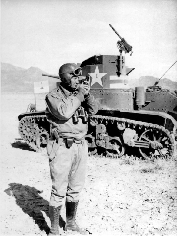
The 1986 production Stocker & Yale lensatic compass I carried
during Operation Desert Shield/Desert Storm.
It sits on the 1:250,000 scale map I used while conducing geographic
and soils analysis in the northern Saudi Arabian desert.
It was the results of these reconnaissance efforts that helped convince
General Schwartzkopf and CENTCOM Headquarters that the
famous ‘left hook’ maneuver was feasible.

It is pretty beat up.  It was already used when it was issued to me back in 1989, and I used it a lot in places like Honduras, Saudi Arabia, Kuwait, Iraq, Korea, Panama and across the US.  Like a lot of things military, it is somewhat overbuilt; a big green chunk of aluminum housing a compass. It was one of those pieces of equipment that you forgot about until you needed it, and when you needed it (particularly in places like Iraq or Panama), you needed it bad.  Whenever I opened it and let the compass card swing free I would always let out a little sigh of relief as the arrow settled down and pointed the way north.

My compass never failed, and that is what we should expect of a compass – it should never fail to point the way.  And they rarely do.  That is the absolute beauty of the compass as a navigational instrument.  It is so simple in concept and design that even poorly made examples do just what we ask of them – point the way north.

The compass is the most basic navigation tool and certainly one of the first, if not the first man-made navigation tool.  Before the compass there was… the human eye?  Well, we had maps of a sort, but they are really not direction finding tools.  Humans had spent thousands of years studying the skies with the naked eye, and got pretty good at estimating location, direction, seasons, etc. using the stars.  Certain groups like the Pacific Islanders even got damned good at open water navigation using just the stars, very rudimentary maps (made of woven plant material and shell) and an intimate knowledge of sea conditions and winds.  But what happened when the clouds closed in and the heavens disappeared?  Mankind was lost.  Literally, lost.


What was needed was a device that pointed the way.


The compass is a device so ancient that it’s true origins are all but lost to us, shrouded in history and mystery and claimed by so many civilizations that the real story will probably never be known.  What we do know is that the properties of the mysterious lodestone (the mineral magnetite) were known to multiple civilizations at the same time.  Mostly it was viewed as a magical substance, it’s attractant properties giving it special medicinal powers.  Ancient physicians concocted all sorts of uses for lodestone, claiming it cured everything from skin rashes to the plague.  Even today you can go on Amazon.com and buy bags of lodestones labeled for use in ‘natural healing’ practices.  (Aroma therapy candles and Yanni’s greatest hits, anyone?).  While it is generally acknowledged that it was the Chinese who discovered the direction finding properties of the lodestone, they never matured the technology beyond the most basic design.
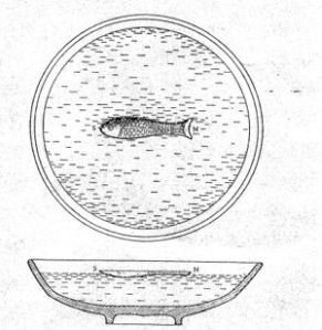
A Chinese compass.
A magnetized chunk of iron (shaped like a fish) suspended in a bowl of water.
Simple, yet remarkably effective.
Alas, it seems they never got much past this stage of development.

What is known is that someone, somewhere, magnetized an iron nail or needle with a lodestone and then noticed that the needle acquired magical properties.  The first thing noted is that when suspended by string or floated on water the needle would swing freely and always pointed in the same direction, as though guided by a mysterious, unseen hand.  The next magical property was that it always pointed to the pole star, or Polaris.  At first this phenomena only served to enhance the perception of the magical properties of the lodestone – if it can impart such magical behavior to a simple iron needle then surely, surely, it must be capable of imparting even more wondrous effects to the human body.  Or predicting the future.  Or curing the insanity.  Or defeating enemy armies.  Or…  Well, you pick an application, because folks back in the Middle Ages thought the lodestone was the answer to just about every problem afflicting humanity.


Eventually someone, most likely a seafarer, figured out that if this magnetized needle always pointed north, regardless of the weather, then it could be useful for indicating direction while at sea.  This sharp sailor probably lived along the west coast of Italy in the 13th Century in one of the bustling centers of seagoing commerce scattered up and down the coast, from Genoa in the north to Salerno in the south.  Italian legend attributes the development of the navigational compass to a guy named Flavio Gioia, who lived in a town just outside of Salerno in the early 14th Century.  Scholarship casts serious doubt on this claim, but since nobody has come up with a better story the Italians are sticking with it.  Plus, it’s good for the tourist trade.

Flavio Gioia.
He may, or may not, have developed the compass into a serious
tool for use aboard ship.  But then, he may, or may not, have
actually existed.  Who knows, but it’s a good story
and we’ll run with it!

What is known is that once the navigational compass was developed it’s use exploded across the Mediterranean Sea, and then across the known world.  I have no doubt that hundreds of 14th Century sailors, stepping aboard a ship carrying one of those newfangled compasses and being told that it uses a needle magnetized by a lodestone, smacked themselves on the forehead and shouted “Why didn’t I think of that?”  It was that obvious.

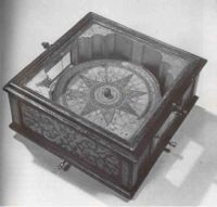
An early Portuguese ship’s compass


The compass is such a simple tool that everything that came after was merely a refinement on the initial design.  Basic refinements came quickly – improvements in indicating direction (development of the compass ‘card’), improvements in mounting and suspeding the needle, improvements in housing the device aboard ship.  The basic compass design was quickly brought ashore and miniaturized, and small and easy to carry compasses began to appear.  For centuries, however, the compass remained a simple device – a needle placed against an indicator that showed the cardinal directions (North, South, East, West, Northeast, Southwest, North Northeast, etc.).   This design seems to have prevailed right up into the 19th Century.

An F. Barker & Son pocket compass from  1858.
One of the earliest pocket compasses I’ve seen that combines both a
traditional compass card showing cardinal directions (N, S, E, W, NE, SE, etc.)
and degree indicators (01 – 360).

What took place in the intervening years was an increased understanding of the properties of magnetisim in general and the magnetic properties of the Earth in particular.  Scientists and experienced navigators had know for years that the magnetic compass didn’t point directly to the pole star, but pointed to the east or west of Polaris depending on where you were in the world.  During the Age of Exploration it was observed that the needle was off a few degrees either direction in most of the northern hemisphere.  In a few places the alignment was perfect – the needle pointed straight north, other places it pointed almost due east or west (particularly at high latitudes), but generally it was just a few degrees off from Polaris.  This fluctuation was not consistent – a scientist or a navigator could not accurately predict what the magnetic difference would be at a future location based on observations at his current location.  Keen observers also saw that the needle itself would not always float horizonally, but would ‘dip’  just a little bit at different locations.  Even more mysterious and concerning, scientists and navigators that returned to the same spot again and again over a period of years noted that the amount of magnetic variation differed.  It was as though something unseen was causing the needle to shift over time.

These observations eventually led to the understanding that the Earth itself is a giant magnet and that the compass needle is not ‘pointing’ north, but the needle is aligning itself with the Earth’s own natural lines of magnetic influence.  This discovery moved the compass from the realm of ‘mysterious instrument’ to ‘well understood tool’.  It also triggered the realization that the compass is a flawed tool, inaccurate and erratic, and to be truly useful for safe navigation its relationship with what we now call true north must be studied, understood and applied.

Rene Descartes (1596 – 1650), French philosopher and physicist
kinda’ sorta’ figured it out back in the early 1600s.

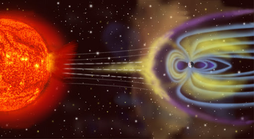
I won’t dive into the details, but Western nations alone or in concert expended huge amounts of money studying the earth’s magnetic properties.  First to apply it to a better understanding of compass accuracy and later to better understand complex geodynamic principles.  (For example, it is the existence of the Earth’s magnetic fields that first led geophyisicists to deduce that the Earth’s core is little more than a huge chunk of iron). The study of magnetisim is still a leading discipline, as scientists work to understand how the Earth’s magnetic field acts as a shield from a lot of the nasty stuff the Sun throws at us, or how a panetary body’s magnetic field can yield enromous information about its interior structure.  Compass users are the happy beneficiaries of a lot of this research, since we now have an intimate understanding of how the Earth’s magnetic field influences our compass bearings.

Yikes!  The Earth’s magnetic field shields us from a lot of
nasty stuff the Sun sends our way.

Today the answer is obvious to us.  The Earth is a giant magnet that has a geographic north and south pole (where the lines of longitude converge) and a magnetic north and south pole (where the magnetic lines of influence converge).  The two don’t match.  In fact, they aren’t even close.  Today the magnetic north pole is located high in the Canadian Arctic about 535 miles south of the geographic north pole, and it is always moving.  The magnetic pole shifts slightly every day in response to influences like solar storms, and over time it drifts – right now it appears to be set to wander over the polar region and settle somewhere in northern Siberia in the next 50 years.

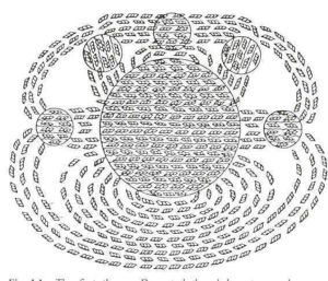
The wanderings of the Magnetic North Pole, 1600 – 2000

While the thought of a wandering pole may cause some readers distress the good news it that we know where its headed and we can accurately track its progress.  If we know precisely where the north pole is located day-to-day we can quickly and accurately calculate the variation between magnetic north and true north for any point on earth.  This calculated difference between magnetic north and true north is known as magnetic declination.

The difference between True North and Magnetic North.
The angular distance between the two poles is what we refer to as magnetic declination.
But why is the south end of the needle pointing North?
Remember your basic principles of magnetism – opposites attract.
The end of your compass needle that indicates North is actually the south end!

In years past governments would periodically publish maps showing lines of magnetic influence, or isogonic lines and include instructions on how to calculate updated declination based on the predicted drift.  However, today you can access one of several web sites that allow you to input your current location and calculate an accurate magnetic declination.  This means you can know precisely the relationship between magnetic north as indicated by your compass and true north, and compensate for declination either directly on the compass or in later calculations.

As far back as 1702 European nations were investigating
and mapping isogonic lines to determine magnetic declination

Knowing the magnetic declination for your location or region and compensating for it is the key step to accurate navigation using a compass!  Once you have mastered this task you can get yourself from one point to the next with confidence.

Whew!  We’ve covered a lot in this posting.  I’ll pause here to let you digest what I’ve presented and to let you do a bit of your own research if you are so inclined.  There are a lot of great resources on these topics available on the web, many of which I’ve linked to in this posting.  Let me add one more link to a NOAA web movie that does a great job of portraying the relationship between the movement of the magnetic poles and the corresponding shifting of the isogonic lines over time.

In the future we’ll take a look at modern compass design and land navigation techniques.

Stay tuned!

Brian