Things of Global Importance – The US National Grid

OK, everybody get on  your beanie hat with the spinny propeller – it’s uber dork time.

As I continue work on my PowerPoint opus magnum on magnetic declination I’m becoming reacquainted with issues, concepts and developments I never paid much attention to in my years of work in the topographic field.

One of these developments is the US National Grid System. (Hey, I warned you this was going to be a dorky post.)

Huh? The US National Grid System?

While the US Geological Survey (USGS) has done an outstanding job of mapping the US at large scales (1:24,000 and 1:100,000) there has never been an ‘official’ map grid system selected for use on US topographic maps. For decades USGS maps have sported both Universal Transverse Mercator and Latitude/Longitude grid tics, in sort of a ‘we can’t make up our minds, so we’ll give you everything’ approach. Problem is that the UTM grid system, while accurate, is clumsy and somewhat difficult for the average hiker, Boy Scout or search and rescue team member to use. Soooo many numbers, and little numbers and big numbers, and some numbers that are repeated, and numbers going north have more digits than the numbers going east. Plus, you have to draw your own lines to connect the tic marks and create your own grid. It’s all so confusing.  And cumbersome.  And unnecessary.

Waaaaay back in the late 1940s the US Army got it figured out, and created the Military Grid Reference System (MGRS). MGRS was (and still is) a map grid system based on the UTM coordinate system, but it is greatly simplified so that a soldier can locate himself with an alphanumeric designator that uniquely describes his position anywhere in the world. The Army extended this standardized coordinate system around the globe (including the US) and over the years has produced hundreds of millions of maps using the MGRS coordinate system. Along the way the Army simplified and standardized map reading techniques using MGRS in conjunction with coordinate scales and compasses, published one of the premiere texts on map reading and land navigation (FM 21-26) and proceeded to teach millions of Soldiers, Marines and the occasional Sailor and Airman the finer points of map and compass work.

Unfortunately the USGS never followed the Army’s example. With only minor exceptions, USGS 1:24,000 scale topographic maps remained grid-less. Users were left to draw their own grids on their maps and figure out the maddening complexity of the UTM coordinate system.

Aaah, but the times, they are a-changing! Recognizing the growing need for a comprehensive national map grid system and spurred, I’m sure, by the post 9/11 drive for standardization and interoperability in national, regional and local disaster response efforts, the USGS has adopted a national map grid system. After much study, conferencing, research, investigation and consideration the USGS took the bold step of….  simply adopting the US Army’s Military Grid Reference System. Now, this is not a bad decision. In fact, it’s a great decision, but geezus guys, you could have done this like, oh, the middle of the last century!

But let’s give credit where credit is due. Once the USGS decided to adopt the US National Grid System they jumped on it like a duck on a junebug. All maps produced under the new US Topo series will incorporate the US National Grid System, will have the full grid overprinted on the map, and legend information will include the full USNG grid identification diagram.


The great news is that if you remember your old Army map reading instructions, the US National Grid System works exactly like the Military Grid Reference System – heck, it is the Military Grid Reference System*, just implemented at a different scale (1:24,000 vs. 1:50,000). All the old rules are the same – remember to include the Grid Zone Designation and the 100,000 meter Square ID. And don’t forget to read right and up!

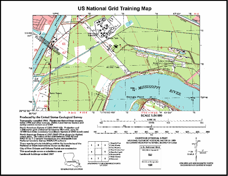
The best way to learn to use the new US National Grid System is to download the Army’s classic field manual on map reading and land navigation, FM 21-26. This FM is approved for public release so feel free to download it and study it. While the mechanics of map location are the same between grid systems, just remember that the scales are different. You can also download and print a US National Grid practice map (shown above) and a 1:24,000 coordinate scale from the Federal Geographic Data Committee US National Grid website.

So, your homework for this week is to download FM 21-26, the practice map and a coordinate scale and practice, practice, practice. There’ll be an exam next week!

Brian

*OK, MGRS and the USNG are not exactly the same, but close enough that the difference doesn’t matter.  MGRS is built on the WGS 84 datum and the USNG is built on the NAD 83 datum.  The ground difference between these datums are roughly 1 meter.  For land navigation purposes this difference doesn’t really matter.  Hey, once again, I told you this was going to be a dorky post!

Maps, Maps and More Maps

I want to place this post under the subcategory of “Best Use Of My Tax Dollars.”

The US Geological Survey (USGS) has the stated mission of mapping the United States. That was one of the foundational roles of the USGS, and it is a role they took on with an almost missionary zeal from the beginning (the USGS was created in 1879 by act of Congress).

USGS set the standard for large scale (i.e., small area) mapping, and their 1:24,000 series topographic maps of the United States are classics.  These are the 7.5′ x 7.5′ quadrangle sheets, commonly known as ‘quads’.  These quad sheets have been used to teach generations of Americans the basics of map reading, terrain association and land navigation.  They have guided millions of hikers,  orienteers, foresters, researchers, explorers, search and rescue personnel, hunters, fishermen, campers and canoers for over 100 years.  USGS maps have, literally, served as the background to America’s love of the outdoors and her expansion and growth across three centuries.

In the old days about the only way to get USGS topographic maps was to order them directly from the USGS or purchase them from a limited number of authorized sales outlets like camping supply stores.  You can still do that if you like – a single USGS 1:24,000 map will run you about $8.00.  Not cheap, but not bad for a high quality map printed via lithographic processes.

But this is the age of the World Wide Web, instant gratification and free data.  The USGS has happily obliged us by putting virtually its entire inventory of topographic map products – at all scales – on line for instant download.  The USGS online store offers an easy to use map search function under the Map Locator link.  You can search for a particular map by address, place name or simply by picking a point in the map in the Google Map window.  Using this process you can either purchase the paper map or download a free digital copy.  The free digital map is a scanned copy of the original paper map in Adobe PDF format.  The scan quality is good – not as good as the original paper map, but pretty darned good for a free product.  These maps can be opened and read using the free Adobe Acrobat Reader application.

As an added bonus these maps are delivered in GeoPDF format.  This means that the geographic extents of the map have been embedded into the digital map file.  If you want to take advantage of this geospatial functionality you can download the free TerraGo Technologies plug-in for Acrobat Reader (available from a link on the USGS Map Store website).  With this plug-in you can set the coordinate system of your choice (i.e., latitude/longitude, UTM, etc.) and select coordinates for features of interest, measure distance and area, measure azimuths and, if you have a compatible system you can link these digital maps to your GPS and use them as your navigation background.

But it gets even better!  The functionality I just described is specific to the old generation of scanned paper maps.  The USGS is producing an exciting new generation of 1:24,000 quadrangle maps known as the US Topo series.  These maps have the same geographic extents as the traditional quadrangle maps, but instead of being created by traditional cartographic methods the US Topo series are created using aerial imagery or satellite imagery as the map background.  This allows maps to be produced and updated much faster than the old traditional cartographic methods allowed.  In many places of the US the traditional quad sheets have not been updated for over 50 years!  The technology behind the new US Topo series of maps allows for much faster updating.  As an added bonus (I think I’m starting to sound like Billy Mays here), since the US Topo maps began life as a purely digital file (they are created using a program called ArcGIS) the production process allows even more functionality to be embedded in the map file.  Users of US Topo series maps will be able to manipulate virtually all of the data embedded in the map, turning data layers on and off.  If you have a copy of Adobe Acrobat (not just Reader) you can make annotations directly on the map, adding comments, symbols and basic sketches.

Zoomed in view of the US Topo map of Maumee, Ohio (my home town).
Using the table of contents on the left you can turn data layers on or off.
This map is focused on the site of the Battle of Fallen Timbers, where General ‘Mad’ Anthony Wayne
defeated the Indian tribes of the Western Confederacy in 1794, opening the old
Northwest Territories (Ohio, Michigan, Indiana) to American settlement.
The battle site is the large patch of woods in the center of the map image.

Bottom line – this is all good stuff, and it’s free.  Go get it!

Brian

GPS

I’ll make this quick.

I’m deep into preparing a briefing/presentation/class on the issue of magnetic declination and the easiest rules to follow when you need to apply it.

What’s magnetic declination, you ask?  Sorry, that’s not the topic of today’s post.  If you really – REALLY – need more information right now check out the Wikipedia page on Magnetic Declination.  I’ll be referring to it in a later post.

Anyway…  I was mentioning to a friend that I was working on this presentation and he commented “Does anyone really care about that anymore?  I think everyone has just gone out and bought a GPS.”

I actually get that reaction a lot when I talk to people about compasses and using a map and compass to navigate.  “Compasses confuse me.  I’d rather just use a GPS” seems to be the common refrain.

(For the uninitiated, GPS stands for Global Positioning System, or space-based satellite navigation system.  There are several operational (US, Russian) and developing (the European Union’s Galileo) satellite navigation systems, but ‘GPS’ has become an almost a generic term used to describe the US developed and operated NAVSTAR system.)

I live and work in the world of GPS.  I’m a geospatial professional and I run the GPS-based survey and data collection program at the World’s Busiest Airport.  Every day I am thinking about, using, training, developing policies on and attending meetings about GPS and how we use it at our airport.  Everything from upgrading our high-precision GPS receivers to providing airport-specific input for the FAAs GPS-based NextGen precision approach program to review and quality control of project layouts generated using GPS-based survey systems.  And more.

I am the biggest cheerleader for the GPS system and GPS-based technologies.  GPS is perhaps the best example of a project that only the United States could do, and do right.  The driver who switches on his Garmin Nuvi for the drive to the airport is leveraging tens of billions of dollars and decades of research, development, testing, deployment, maintenance and upgrades.  All paid for by the US taxpayer, and all free to any user anywhere in the world.

Conceptually the GPS system is simple – satellites in space broadcast their position and your receiver (example – our driver’s Garmin Nuvi) uses time shift calculations to determine the precise distance from your location back to the satellite.  Once the receiver picks up and processes signals from at least two more satellites it can triangulate your position.  The size of the position ‘triangle’ determines the accuracy of the position fix provided by the receiver, but in general a modern receiver tracking three or more good satellite signals can locate you to within about 15 feet of your true position anywhere on earth.  That’s pretty damned good by anybody’s reckoning.

GPS has revolutionized many industries and spawned completely new ones.  GPS systems are so pervasive that most people no longer give them a second thought.  Today GPS technology tracks your package as it travels from the retailer to your door, and it tracks the paroled felon sporting the nifty ankle bracelet.  GPS technology manages the hand-off of your phone conversation from one cell tower to another as you speed down the interstate, and GPS technology guides the angle of the bulldozer blade working a local road construction project.  Anything that locates you on a map is universally identified as ‘GPS’, even if the function has nothing to do with satellite-based navigation.  GPS has become an integral part of our lives and impacts us for the better every day.

And yet, GPS is a system with serious limitations.  It can’t locate you indoors, in tunnels, under overpasses, in dense forests or even in the man made canyons of large cities.  The signals can be easily corrupted, blocked or bounced around so much they are virtually useless.  The entire GPS system is a delicate balance of high technology and rocket science, enormously expensive to maintain and upgrade.  At some point the GPS system – certainly a system that succeeds what we have now – will fail.  It will fail due to funding shortfalls, political upheaval, changing national priorities or simple neglect.  This failure is merely a recognition of a historical inevitability – man made systems always fail at some point.

Long after the GPS satellites go cold and dark in their far orbits and GPS receivers become little more than technological oddities, the magnetic compass will continue to offer reliable wayfinding.  Using a compass (along with a map) is not easy or intuitive for most people, but once learned it provides a reasonably accurate, reliable, steady and ‘always on’ navigation capability that can not be turned off by man’s whim or neglect.  I feel fairly certain that at some time in mankind’s future we’ll be back to navigating using the simple, reliable magnetic compass.  It’s inevitable.

That’s why I still practice my map and compass skills.