Right Under My Nose The Whole Time

As many of you know, I’ve been scratching around for some time trying to dig up the origins of the Military Grid Reference System (MGRS). I recently became interested in it in light of the fact that the US Geological Survey and Department of Homeland Security have adopted MGRS as the grid standard for the continental US (they’re only 60 years late, but who’s counting!).

I had some old friends at Fort Bragg who are involved in the mapping & charting field root around and they came back with the opinion that development of MGRS was likely tied to NATO and NATO standard agreements (STANAGs as we used to call them). There is probably some truth to that, but there were still several pieces of the puzzle missing. One of those was just when the US Army adopted MGRS.

For the past several months I’ve been scouring eBay, purchasing early copies of US Army map reading and land navigation manuals. The first official, general issue map reading manual came out in 1938 (Basic Field Manual Volume 1, Chapter 5, Map and Aerial Photograph Reading) and was quickly followed by updates in 1941 and 1944 as FM 21-25.

Tucked away in the back of my 1944 copy of FM 21-25, Elementary Map and Aerial Photograph Reading were two changes that I never paid much attention to. ‘Changes’ in Army parlance were updates to manuals or other documents. The Army would publish a change in the form of an addendum and distribute it throughout the Army. It was the individual unit’s job to make sure all the changes were ‘posted’ (this usually meant you physically attached the change document to the base document by some means, like stapling). That’s how the military managed publication changes before this internet thingey came along.

Today I was giving this manual a close read and decided to pay attention to the change documents. To my surprise one of the changes (Change 2) was dated November 1950 and was summarized as follows:

“Principal changes are in methods of giving grid references. These changes are made to comply with AGAO-S 061.3 (28 Dec 49) CSGID-M, dated 29 December 1949, which establishes the MILITARY GRID REFERENCE SYSTEM as official for the Department of the Army”

So there you have it. The Army adopted MGRS in December 1949. Part of the mystery solved!

So now I know the why and the when. What’s still missing is the how.

MGRS is based on the Universal Transverse Mercator Grid (UTM), which was developed by the Army Map Service sometime right after WWII.  What I need to find now is the original description of UTM and MGRS, the document prepared by the Army Map Service describing how MGRS is calculated and constructed, and how it should be implemented.

My guess is that these founding documents are buried deep in the archives of the National Geospatial-Intelligence Agency (the descendant of the Army Map Service).

Anybody know someone at NGA who can spend a lunch hour digging around for this info?

– Brian

Inter-American Geodetic Survey

The Inter-American Geodetic Survey (IAGS) was one of those extremely successful, yet little known, US Army (and later, Dept. of Defense) programs established after WWII.

The IAGS was created specifically to assist Latin American countries in surveying and mapping their vast internal regions that were either poorly mapped or entirely unmapped. The IAGS was established in 1946 as part of the Army Map Service and was headquartered at Fort Clayton in the Panama Canal Zone. The Army Map Service set up a complete survey, cartographic and map reproduction school at Fort Clayton and over the next 30 years trained thousands of military and civilian personnel from most Latin American and Caribbean countries. Attendance at the IAGS school at Fort Clayton was seen as right of passage for many up and coming officers in Latin American militaries, and it was common to run across senior officers – colonels and generals – from South American countries who talked fondly of their time spent at Fort Clayton, taking surveying or cartographic classes (one infamous graduate of the IAGS schools just happens to be Panamanian dictator Manuel Noriega, who attended the cartographic school in the 1960s).

The IAGS didn’t just provide training.  It also provided the equipment and personnel to assist the participating countries in establishing their own self-sufficient mapping and surveying programs.  The goal was to provide the training, equipment and technical support but have the individual countries take over their own mapping efforts.

Now, I’m not going to pretend that the IAGS was all altruistic good-will on America’s part.  We learned the hard way during WWII that many Latin American countries were at best reluctant allies, at worst active sympathizers with the Nazi regime.  At the end of WWII the political systems in these countries ranged from shaky democracies to hard line dictatorships.  The US Government became concerned about the effects of political unrest and Communist influence in the region, and instituted a number of programs designed to bring Latin America firmly under American influence and to foster democratic principles and improve economic conditions.  The IAGS was just one of many programs created as part of this effort.  One extremely important benefit the IAGS provided back to the US was that we were able to get American personnel on the ground in these countries to make detailed evaluations of local conditions (after all, that’s what surveyors and cartographers do, right?) and we got maps that were created to US standards for vast areas of Central and South America.

According to all the accounts I’ve read and my own direct experience with the IAGS in Central and South America, the program was a great success. The goals of the IAGS were warmly embraced by most countries, who realized they utterly lacked the resources and training needed to map their own territories. IAGS liasion personnel were permanently assigned to each country, working out of the US embassies, and developed deep and lasting ties with government, military and business leaders.  IAGS personnel were very highly regarded in most countries, and I’ve heard more than one old-timer talk about how whenever they flew into a country to work and the local customs agents saw the distinctive IAGS logo on their luggage they were swiftly and courteously passed through customs without inspection or interrogation.

My introduction to the IAGS came when I attended the Defense Mapping School’s Mapping, Charting & Geodesy Officer’s Course at Fort Belvior, Virginia back in 1982.  By then the IAGS had been, or was in the process of transforming into, the Defense Mapping Agency International Division (I’m running on memory here, so please forgive any errors). However, the IAGS logo was visible throughout the building, and we received a short orientation brief on IAGS operations.  My next contact came in 1990 while working in Honduras as part of an airfield construction task force.  My team’s job was to conduct route reconnaissance and terrain evaluation of large sections of southern Honduras.  We made contact with the Honduran IAGS liaison officer, Emory Phlegar.  Emory was a long time IAGS hand who had ‘gone native’ – he married into Honduran society and seemed to know everyone and everything that was going on in that small, poor country.  He provided us a wealth of information and with a simple phone call opened a number of doors for us with the Honduran Instituto Goegrafico Nacional (National Geographic Institute).

Three years later I was stationed at Fort Clayton, Panama, and headed up the geographic analysis team supporting US Army South and US Southern Command.  This job put me in close and frequent contact with the last remnant of the IAGS in the old Canal Zone. Southern Command and the Defense Mapping Agency (DMA) ran a joint map warehouse on Albrook Air Force Station.  The Air Force took care of ordering, stocking and issuing standard US maps to all US military operating in Central and South America.  In the same building the Defense Mapping Agency ran a small but very interesting and critical ‘local products’ warehouse that received and stocked maps printed by the different countries who had been part of the IAGS.  By agreement, DMA received 100 copies of every map printed by the participating countries. Quite often these maps were the only representation of Central and South American land areas available to the US military, and we relied heavily on this map supply. In fact my unit acquired an early large format Xerox copier specifically to make copies of these maps for Army use so as not to draw down the limited stock kept by DMA.

Additionally, DMA continued to operate a topographic and survey instrument repair shop out of the building.  This was a one man show, employing an instrument repairman who fixed or calibrated any equipment that had been loaned to countries participating in the IAGS.  Much of the loaned equipment was simply too big to pack up and send back to Albrook to be worked on, so this lone repairman spent a lot of time on the road traveling from country to country repairing equipment.  Most of what he worked on was obsolete by US standards, but was still perfectly serviceable and suitable to the Latin American countries that couldn’t afford anything more modern. As such, his workshop at Albrook was a fascinating mix of spare parts bins and machine tools.  Since he dealt with a lot of obsolete equipment I’m sure he had the skills and equipment needed to fabricate any broken or worn part.

Unfortunately there is very little information about the IAGS on the web.  Not even Wikipedia has a dedicated page, and only catalogs indirect references to the agency. This is a shame, because the IAGS was a landmark cooperative effort that yielded enormous benefit for all countries involved, and its story needs to be out there for everyone to read. Somebody at the National Geospatial-Intelligence Agency (the successor to the Defense Mapping Agency) or the Corps of Engineers needs to write up a short history of the IAGS and its accomplishments while the participants are still around to tell their stories.

But for now it is You Tube to the rescue!  I found this film, part of the Army’s ‘Big Picture’ series, covering IAGS operations:

Enjoy!

Brian

A Man for All Seasons

December 31st is the birthday of one of the greatest Americans of the 20th Century.

George C. Marshall was born in 1880 in Uniontown, Pennsylvania.  He attended the Virginia Military Institute, graduating in 1901 and then competing for and winning one of the few coveted officer commissions reserved for non-West Point graduates.  In virtually every assignment Marshall stood apart from his fellow officers, exhibiting a keen military mind and outstanding leadership traits even as a junior officer.  One of his peers, observing the young Lieutenant Marshall direct what was essentially a regimental-level exercise in the Philippines commented to his wife “Today I watched the future Chief of Staff of the Army at work”.

Few people understand that the US Army didn’t just magically appear on the battlefields of WWII and decisively defeat the Germans and the Japanese.  The foundations of the American Army that won WWII were set years before Pearl Harbor by George C. Marshall.  It started in the trenches of WWI, where a dynamic young Marshall was assigned as the G-3 (Operations) of the 1st Division and later the Assistant G-3 of the American Expeditionary Force (AEF).  Marshall saw first hand the devastation and human suffering caused by a stalemated war that had devolved into static trench warfare, and the effect that poor leadership and poor military decision making had on units and individuals.  He learned those lessons well and carried them with him as he moved up in rank and responsibility.

Between 1918 and 1939 Marshall had a number of assignments that, in retrospect, were key to his success as Army Chief of Staff.  The first was his assignment as Aide-de-Camp to General John J. Pershing.  One of Marshall’s roles in this assignment was in helping General Pershing compile the Army’s official history of its involvement in WWI.  Marshall was able to spend time studying the broader issues that impacted America’s involvement in the war, particularly in the areas of training, leadership, military force structure and industrial readiness.  By this time Marshall was already thinking at the strategic level and he understood that the core issues of WWI had not been settled with the armistice.  He concluded that America would probably be at war again on the European continent within the next 30 years.

Marshall’s next key role came in 1930 when he was assigned as the Assistant Commandant of the Infantry School at Fort Benning, Georgia.  Marshall turned the Infantry School into a laboratory, investigating and testing new tactics and force structures.  Marshall understood that mobility and firepower were the keys to success on future battlefields, and he put sharp young officers like Omar Bradley, Joseph Stillwell, Walter Bedell Smith and Matthew Ridgway to work revamping Army doctrine to reflect this new thinking.  Out of this work came the concept of the smaller, more agile triangular division with more organic firepower, motorization (the horse was about to be left behind), improved communications using the newfangled radio and the integration of armor and air support into a ‘combined arms’ concept.  What is fascinating is that advanced military thinkers in Germany were working along the exact same lines, developing the concept of ‘Blitzkrieg’ – the lightning war spearheaded by fast moving armor forces.

After the Infantry School Marshall was assigned as Commander of the 8th Infantry Regiment in Georgia.  During this assignment he was also appointed as the district military commander for the Civilian Conservation Corps (CCC).  Most military professionals resented being ‘stuck’ with the CCC responsibility by President Roosevelt, but Marshall understood that the CCC would provide vital experience to Army junior officers and NCOs.  In future wars involving mass mobilization officers and NCOs would need experience in routine tasks like receiving, housing, training, feeding, moving, caring for, accounting for and employing large groups of young men.  The CCC role provided just this experience, and Marshall embraced it.

Marshall’s next assignment (1933 – 1936) seemed to him, and his peers, as banishment to the wilderness.  A petty and vindictive Army Chief of Staff, General Douglas MacArthur, had Marshall assigned as the senior advisor to the the Illinois National Guard.  Apparently MacArthur was upset at Marshall’s support of the CCC program (something MacArthur hated and fought endlessly with Roosevelt about).  The politically connected Illinois National Guard wanted a talented Regular Army officer to be assigned as advisor, but National Guard advisor positions were viewed by the Regular Army as something second-tier officers got stuck with.  MacArthur saw this as an opportunity to placate the Illinois politicos and send Marshall a message.  In typical Marshall fashion he made full use of the assignment, evaluating the National Guard from the inside, developing a keen understanding of their training and readiness and mapping out the political sub-structure that supported the National Guard systems in most states.  This understanding would be critical when Congress federalized all National Guard units for integration into the Regular Army after Pearl Harbor.

After the National Guard advisor position Marshall was promoted to Brigadier General and went on to command the 5th Infantry Brigade in Washington State and more CCC involvement.  By 1938 the threat of war in Europe was again looming and Marshall’s talents were finally recognized at the national level.  He was pulled to Washington D.C. to head the War Plans Division.  In 1939, on the recommendation of the outgoing Army Chief of Staff General Malin Craig, Marshall was promoted to four star rank and appointed Army Chief of Staff by President Roosevelt.  I consider it one of Roosevelt’s most prescient moves that he recognized Marshall’s talents and promoted him over dozens of other Army general officers with more seniority.

Finally, George C. Marshall’s experience and skills were turned to what he had been anticipating, yet dreading, since 1918 – preparation of the US Army for global conflict.  With the foundations in place and solid support of the President, and Secretary of War Henry Stimson, Marshall set in motion his plan to prepare the Army for modern war.

The new Chief of Staff understood better than anyone that the next war was going to be fought by young Americans who were not just citizen soldiers, but they were the sons and husbands of American citizens and as such deserved to be led by the very best.  Yes men would die, but they should not die needlessly or because of a failure of leadership or training.  It was the Army’s responsibility to provide the very best officer and NCO leadership and training possible.  Towards that end, Marshall cut a wide swath through the Army, firing or retiring hundreds of senior officers who were too old, too out of shape or just plain incompetent.  (One politically dangerous move was his firing of virtually all National Guard division commanders soon after their divisions were federalized.  He realized from his National Guard advisory experience that these commanders were little more than political hacks and were not up to commanding divisions on the modern battlefield.)  At the same time Marshall reached down into the Regular Army officer ranks and pulled up dynamic young men he knew could perform.  Virtually overnight talented officers like Omar Bradley, Mathew Ridgway, Mark Clark, Walter Bedell Smith and Dwight Eisenhower found themselves jumping rank and position on the fast track to senior command or staff positions.  As an example, in early 1941 Omar Bradley was promoted directly from Lieutenant Colonel to Brigadier General, bypassing the rank of Colonel.  A year later he wore two stars and was commanding the 82nd Infantry Division (before it was designated an airborne division).  If General Marshall knew you and you measured up to his exacting standards you could expect fast promotions and increased responsibility.

General Marshall also revolutionized the Army machinery that created small unit leaders.  Prior to 1940 you could still become an Army officer by direct political appointment or even election or acclimation by members of the unit (this is how Harry Truman got his commission in WWI).  While this system only existed in the National Guard system at the time, it was still viewed as a viable method of obtaining a commission.  Marshall put an end to all that and standardized policies and procedures for obtaining officer rank in the Army.  He also knew the Army’s demand for unit leaders at the platoon and company level would be almost insatiable and the existing commissioning programs, West Point and ROTC, would not meet the demand.  Marshall also knew that the Army already contained a vast pool of potential officers – the enlisted ranks.  Every day thousands of young men were volunteering or were being drafted who had some college experience and would make excellent officers.  Marshall directed the establishment of the Officer Candidate School (OCS) program at Fort Benning.  Following a curriculum developed by General Omar Bradley the OCS program took talented and educated enlisted men and turned them into Second Lieutenants.  This program was so successful that it became the primary commissioning source for the US Army in WWII – far surpassing the numbers of officers generated out of West Point and the college-based ROTC programs.

Even as Army Chief of Staff, General Marshall never lost focus on or sight of the individual soldier.  Immediately after Pearl Harbor his advisors notified him that no more silk would be imported due to the war with Japan (the world’s major producer of silk).  Silk was now classified as a strategic material and it was up to Marshall to determine how the Army’s share of it would be used.  There was a lot of demand for silk – for use in uniform neckties, socks, flags, pennants, even as powder bags for artillery ammunition – and it was clear the available supply would not last long.  Marshall directed that the available silk be reserved for just two uses – as parachutes and as award ribbons.  The General understood that award ribbons were important to the soldier.  They were (and still are) the Army’s visible recognition of service and valor, and those little bars of silk would end up meaning a lot to the millions of soldiers just entering military service.  Award ribbons made of dyed cotton or wool look like junk compared to silk, and Marshall knew that.  The soldier deserved the best, and only silk would do for this important purpose.  With the development of nylon for use as parachute canopy material early in the war virtually the entire Army stock of silk ended up being used for the production of award ribbons.  General Marshall knew it would be important to the common soldier, so it was important to him.

George C. Marshall, like Cincinnatus, wanted nothing more than to retire and live out the rest of his life as a gentleman farmer and historian.  On November 18th 1945 he retired as Chief of Staff of the Army and he and his wife fled to their small estate in Virginia.  The most powerful military figure in the world finally found peace and pleasure in puttering around his house, painting shutters and planting shrubbery.  Less than ten days later he received a personal phone call from President Harry Truman asking him to become his ambassador at large and travel to China to try to untangle that growing mess.  Marshall’s sense of duty would not allow him to say no, and he was launched on his second career as diplomat, Secretary of State and father of the Marshall Plan which financed the reconstruction of Europe and ensured that Western Europe remained free of Soviet domination.

George C. Marshall died on October 16th, 1959 at Walter Reed Hospital in Washington, D.C.  I have been told that at the announcement of his death grown men, many of them with stars on their collars, broke down and cried.

In my estimation George C. Marshall is the key figure in the story of America’s success in WWII.  General Marshall is the reason we fielded the excellently trained, equipped and led armies we did between 1942 and 1945.  More than any one person he was the architect of America’s victory in WWII and shaped the free world that came after.

He was the indispensable man.  The man for all seasons.

– Brian

The Pocket Transit

In Which Way North? (Part I) we discussed the history of the magnetic compass and talked a bit about magnetic declination.  Now let’s start looking at some specific compass designs and discuss why they were important.

To start we’ll look at a compass design that is uniquely American and was born of the late 19th Century explosion of mining and mineral exploration in the US.  This compass was originally conceived to fit a very specific need, but it was so well designed and executed that it found use in a wide variety of applications and industries.  It continues to be produced today, over 100 years since its introduction and little changed from its original design.

The Brunton Pocket Transit was patented in 1894 by David Brunton, a Colorado mining engineer.  Brunton was frustrated by the number of survey instruments a mining engineer and geologist had to carry around with him (and I say ‘him’ because mining engineering and field geology was an exclusively male profession well into the 20th Century).  In the late 1800s it was not unusual for engineers and geologists doing basic exploratory mineral mapping to lug around full sized survey transits, surveying compasses, tripods, clinometers, and plane tables. These instruments offered a high level of accuracy that simply wasn’t needed for exploratory surveys.  As an engineer himself Brunton realized that what was needed a portable device that allowed field survey personnel to do fast and accurate exploratory quality surveys without being burdened down by equipment that was heavy, expensive and difficult to set up and use.  These men were in the business of discovering, verifying and mapping mineral deposits that covered vast areas.  Huge sums of money were at stake as mining and mineral companies scrambled to secure valuable leases on the stuff that was fueling America’s exploding industrial economy – timber, gold, silver, coal, iron ore, chromium, nickel, bauxite, petroleum and dozens of other minerals that were key to America’s growth.  Field engineers and geologists needed to move fast, do rough mapping and get that information back to the office for the development of lease maps and boundary descriptions.  They didn’t need to be burdened with heavy, sensitive and fragile survey gear if that level of accuracy wasn’t required.  David Brunton recognized the problem and set to work developing a solution.

What Brunton came up with as a pocket-sized device that incorporated an accurate magnetic compass with a sighting vane, a clinometer, a level and a large mirror with a sight line.  Housed in a machined aluminum case (still an expensive material in the late 1800s), it was rugged, reliable and useful.

Brunton named his instrument the ‘Pocket Transit’, a lofty title for a fairly rudimentary mapping device.  But the name served its intended purpose; in the mind of the engineer and geologist it set the device apart from the common handheld compass.  Here was a professional instrument that offered a level of accuracy and functionality not found elsewhere.

Brunton’s 1894 model Pocket Transit

Brunton had more than marketing on his side.  The Pocket Transit actually delivered where it mattered – in the field and in the hands of engineers and geologists across North America.  It delivered all the functionality and accuracy needed to get the job done.  It ended up being the perfect device for the job at hand.

Demand for Brunton’s device increased steadily and improvements were introduced.  An additional bubble level and a cover mounted peep sight were added in 1912.  In the same year Brunton introduced modifications to the case that allowed mounting the instrument on a non-magnetic tripod or jacobs staff.  (It’s interesting that in his 1894 patent application Brunton derided other compass designs that needed to be tripod mounted, but in the 1912 patent application he discusses tripod mounting like it’s the greatest idea since sliced bread.)  Somewhere between 1894 and 1912 the Pocket Transit acquired the ability to pre-set magnetic declination by use of an adjustment screw on the side of the case.  By 1926 Brunton’s design had fully matured with the addition of a bullseye level for improved leveling and the addition a percent grade scale to the clinometer.  From this point forward it was minor improvements in materials, manufacturing techniques and the added availability of different compass ring layouts (degrees, quadrants, mils, etc.)

A 1926 patent model of the Brunton  Pocket Transit.
Note the round level and the percent grade indices
at the bottom of the clinometer scale.  This is the basic
design still in production today.
One of the reasons Brunton’s pocket transit was
so damned useful is that he made it a complete package.
Early in the production of the pocket transit Brunton started
engraving sine and tangent tables on the lid.  Using these
tables in conjunction with the clinometer an engineer could
quickly and accurately determine heights of objects like trees
or cliff faces.  To this day Brunton includes the sine and
tangent tables on the lids of all pocket transits.
So damned useful!
From the beginning David Brunton licensed the Colorado instrument maker William Ainsworth & Sons to produce the pocket transit.  After Brunton’s death in 1927 Ainsworth purchased the manufacturing rights to Brunton’s designs and continued manufacturing and improving the Pocket Transit through the late 1960s.  In 1972 the production rights and the Brunton name were purchased by the Brunton Company of Riverton, Wyoming.  The Brunton Company continues to manufacture this basic design.

The Brunton design was so well thought out that engineers and geologists quickly developed field techniques keyed to the Pocket Transit’s unique layout and construction.  The best example is the determination of the strike and dip of rock formations.  Most sedimentary and metamorphic rock formations are not horizontal.  They were all deposited in horizontal layers but over geological time (i.e., millions of years) those horizontal layers have been warped and deformed by pressure and other geological forces.  One of the keys to understanding these forces is mapping the strike (the horizontal angle of deformity) and dip (the vertical angle of deformity) of individual rock layers.  Before the Brunton Pocket Transit the measurement of strike and dip was a clumsy process involving two separate devices – a field compass (often a fairly large and somewhat fragile device) and a clinometer.  With the Brunton the process is quick and simple – open the instrument and lay it horizontally against the rock formation.  Keeping the edge of the instrument in contact with the rock face rotate it up and down slightly until the circular level is centered.  Note the magnetic azimuth as indicated by the compass needle.  That is your strike.  Score a line on the rock face horizontal to the pocket transit using a piece of chalk or small piece of rock and remove the pocket transit.  Make another score mark that is perpendicular to the horizontal mark you just made (your mark should look like a ‘T’).  Place the Pocket Transit along this perpendicular mark and measure the angle of slope using the built in clinometer.  This is your dip.  It takes longer to describe than it does to do it in the field.  This is the standard measurement technique for strike and dip, and every college and university geology department in North America teaches it as part of their field geology curriculum.

From the University of Calgary website.  Measuring the strike
of a rock formation using a Brunton Pocket Transit.
From the University of Calgary website.  Measuring the dip of
a rock formation using the Brunton Pocket Transit.
My introduction to the Brunton Pocket Transit came in the mid-1970s while studying geology in college.  We learned strike and dip measurement techniques early on in the field methods class, and later during our summer field geology course we ranged across the southwestern United States, making thousands of strike and dip measurements in an effort to understand the geologic processes that formed the unique landscape of that region.  I saw the Pocket Transit as a useful but fairly limited device, suited only to the field geologist.  Years later while attending a course at the Defense Mapping School at Fort Belvior, Virginia, our class got an intensive block of instruction on the use of the Pocket Transit not just for strike and dip measurement but for height determination, precise azimuth determination, basic plane table survey work and rough site layout.  I finally saw the full potential of the Pocket Transit and purchased my first one soon after.  That Pocket Transit has seen service in Kuwait, Honduras, Panama, Germany, Bosnia, Korea and across the US.  It has been a constant companion on hundreds of field surveys, assisting with tasks like mapping out refugee camps on the Empire Range area of the Panama Canal Zone, measuring road grades along the Pan-American Highway in Honduras and fixing North Korean observation point locations along the Korean DMZ.

The Brunton Pocket Transit doesn’t measure horizontal angles as well as a conventional transit, it doesn’t measure vertical angles angles as well as a theodolite, sextant or even an Abney hand level.  If you need to shoot azimuths using handheld techniques the Army lensatic compass is a better tool.  However, the Pocket Transit does all of these tasks well enough, and puts everything needed into a compact, easy to carry package that really does fit into your pocket.  (In his patent application David Brunton noted that the instrument fits nicely into a vest pocket – therefore the name pocket transit).

Let’s have a look at some Brunton Pocket Transit variations (click on the pictures for an enlarged view):

This is a modern incarnation of the Pocket Transit – a glass filled composite
body version.  This particular Pocket Transit is almost 20 years old
and has been used around the world, and it still looks new.
This is a particularly nice WWII era Pocket Transit manufactured in 1943.
This model is graduated in mils (6400 mils in a circle).  Designated the
M-2 Compass, it was designed for use by artillery troops who need a more
discreet subdivision of the circle for accurate artillery gun laying and spotting.
A variation of this model is still used by the US Army and USMC today.
An early induction dampened model graduated in degrees
A nice post-war model graduated in quadrants instead of degrees.
Most early Pocket Transits were sold with the quadrant setup rather than
degrees.  The use of quadrants was the accepted method of noting direction
within the engineering and geology community up through the 1970s.  Brunton
still sells a modern version of this layout, but it really is useless for general
navigation purposes.  If you want to do land navigation with a Pocket
Transit get the model laid out in degrees!

As you can tell, I think the Brunton Pocket Transit is a nifty little tool.  But it is not a novelty, not something to be put on a shelf to be admired.  The Pocket Transit is designed and built to be used.  It represents American ingenuity at its best.  From 1894 on the Pocket Transit ended up being used in all corners of the United States, doing useful, often rough duty helping to map American and her natural resources.  Rugged, reliable, useful.  American to the core!

Brian

In writing this blog post I relied heavily on several sources that I feel need to be acknowledged.

First is William Hudson’s excellent website About Brunton Pocket Transits.  Mr. Hudson’s site is the most complete compilation of information about Pocket Transits on the web, and should be the starting point for anyone interested in finding out more about these great little devices.  Thanks you Mr. Hudson.

Next is Dr. Peter H. von Bitter’s article The Brunton Pocket Transit, A One Hundred Year Old North American Invention.  Originally written in 1995 for the journal of the History of the Earth Sciences Society to celebrate the 100 year anniversary of the invention of the Brunton Pocket Transit, von Bitter’s article forms an excellent short history of the man David Brunton and his famous invention.  Thank you Dr. von Bitter.

Although not source, there is an scanned copy of a 1913 Ainsworth bulletin available on the the Surveying Antiques website.  This bulletin describes the various ways to hold and use the Pocket Transit and is an interesting overview of the instrument and its uses.

A Date That Will Live In Infamy

We didn’t ask for it, didn’t instigate it and didn’t want it.


But three years and eight months later we sure as hell finished it.


My salute to those that served on that fateful day in December, 1941, and to the millions that followed them into battle around the world to give us the liberty and prosperity we enjoy to this day.

Lasting Impressions

Roberta and I were having lunch today in our favorite BBQ joint (Cafe Pig in Peachtree City, Georgia). As we were talking I looked up at the bric-a-brac on the wall and noted a copy of a painting of Franklin Delano Roosevelt. It was the painting that was being worked on the day of his death in Warm Springs, Georgia – April 12, 1945.

Unfinished Portrait of FDR by Elizabeth Shoumatoff. FDR was sitting for this portrait at Warm Springs on April 12, 1945 when he complained of a terrific headache and then collapsed. He died later that day of a cerebral hemorrhage. A copy of the painting still sits in an artist’s easel in the living room of the Little White House, as though waiting for the subject to come back to finish the sitting.

Roosevelt was a blue blooded patrician from the Hudson River Valley, a member of an extensive family that traced its roots back to the earliest Dutch and Huguenot settlers to establish a foothold in the New York region. One of his cousins, and his personal hero, was Theodore (Teddy) Roosevelt, Assistant Secretary of the Navy, commander of the Rough Riders in the Spanish American War, Governor of New York and later the 26th President. Born into privilege and wealth and blessed from birth with family connections that could have carried him anywhere in the Republican political world, FDR chose instead to run as a Democrat. In his first political foray in 1910 – a run for New York State Senator – he sensed correctly that Democrats were poised to take control of the New York statehouse. This began his lifelong political career as state senator, Assistant Secretary of the Navy, Governor of New York, vice-presidential candidate, Governor of New York and, ultimately, US President.

FDR’s life history is one of the better known and studied among US presidents, and for good reason – the length of his presidency (12 years), his personal struggles with polio, his efforts to pull the US out of the Great Depression, his struggle to maintain neutrality in the face of mounting world crisis and, ultimately, his leadership in WWII all leave plenty of rich pickings for historians. FDR also had the good fortune of being in office just as broadcast radio emerged as a reliable and widespread communications medium, and he used it skillfully to take his message directly to the American people. For many Americans in the 1930s FDR was the first President they ever heard speak live, and through radio they heard him often. That high, nasal patrician voice gave comfort and reassurance to millions of Americans struggling to just survive.

FDR was an extremely skilled politician, manipulator and chameleon. He played his audiences like a finely tuned musical instrument, and he was rarely off key. It has been said that an FDR appearance was like grand theater, and when you met him one-on-one and got the ‘full Roosevelt treatment’ you came away awed by the experience and the man. It also left historians with a treasure trove of radio broadcasts and newsreel footage with which to balance the often dry recitation of a presidential administration as evidenced by the paperwork it left behind. Unlike any President that came before, the modern media of radio and film allowed Americans to view the President as a human being, not a figurehead.

Yet I am of two minds when it comes to the FDR as president. I greatly admire his foresight and leadership in WWII. His early (and probably illegal) efforts to skirt the US neutrality laws ensured that Britain survived until America’s entry into the war. FDR also brought the full weight of his political and diplomatic skills to bear on pre-1941 efforts to expand and modernize our armed forces in preparation to face what he saw was America’s inevitable involvement in WWII. I don’t think any other president could have done a better job.

On the other hand, his undisciplined tinkering with the US economy and his administration’s abandonment of free market principles certainly extended the Great Depression. Everything his administration did between 1933 and 1940 only served to stifle US economic growth. Many economists today reluctantly admit that had Roosevelt simply left the economy alone and allowed the free markets to correct themselves the economy would have rebounded much faster than it did. In the end it took a world war to pull us out.

FDR also kicked off an expansion of the federal government that continues unbridled to this day, although I’m sure he would be appalled at just how big, how far reaching, how intrusive and how liberal the government has become.

But all this is neither here nor there in relation to today’s posting. Our lunch today reminded me of the the impressions FDR directly made on the State of Georgia. When you travel through west central Georgia, from just south of Atlanta to Columbus, you travel through FDR territory. The story of FDR’s legacy in Georgia is one of the fascinating back-stories of history.

In 1921 FDR was struck down by polio. His search for a cure, or even moderate alleviation of his symptoms, led him to the resort of Warm Springs just outside of Pine Mountain in Georgia. At the time he discovered Warm Springs in 1926 it was a small resort that had seen better days. Using his personal fortune and political influence he built Warm Springs into a leading hydrotherapy treatment center (and it remains a leading paralysis treatment center to this day).

But to FDR it became much more than just a place to find a cure. He fell in love with Warm Springs and the Pine Mountain area. It was a place where he could find relief from the pain and crippling effects of polio, where he could work his personal magic by encouraging fellow paralytics and where he could be himself without any pretensions. He wasn’t ‘Governor Roosevelt’ or ‘President Roosevelt’ to the hundreds of kids who came to Warm Springs for treatment. He was simply ‘Mr. Franklin’, a fellow polio victim who encouraged them, cajoled them, played with them in the pools, shared their joy when treatments worked, kept their spirits up when treatments failed. He helped pay for their therapy, sponsored parties and picnics, took them on drives through the countryside and up into the mountains. He was one of them, in body and spirit.  Many observers noted that at Warm Springs FDR was truly himself.

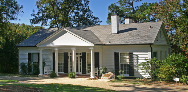
FDR was so in love with Warm Springs that in 1932 he built a cottage there that became known as the Little White House. This is where FDR stayed whenever he was in Warm Springs. Significantly, Eleanor Roosevelt hated the place and only visited once or twice. This meant that the Little White House became a place of solace and refuge for FDR. It is where he went to escape the pressures of the Presidency and WWII.

FDR’s Little White House, and it is little!  Three small bedrooms, a small kitchen and a living room, but a wonderful porch with a great view. It is amazing to think FDR would run the country from this small cottage for weeks at a time.

But FDR did more than just drop in to Warm Springs and the Little White House for treatment. He was too much of a politician to just soak in a pool for a few hours. He needed to get out and get around, see what the people are doing, get their stories. He had a compulsive need to press the flesh.  And he did it from the driver’s seat of his car.

FDR would roam Meriwether County, driving his specially modified Ford. He would stop and talk to local farmers, sharecroppers, laborers, store keepers, politicians, anyone who wanted to chat. White or black, it didn’t matter. He would listen to their problems, issues and concerns, and he turned much of what he learned from those conversations into programs through New Deal legislation. FDR’s roamings were so extensive that even today it is easy to find people around Pine Mountain and Warm Springs who remember being held up by their parents as they chatted with the President or climbed on the running boards of his car as he stopped in town. It seems at one time or another about half the residents of Meriwether County claimed to have spoken with, had lunch with or had a drink with Franklin Delano Roosevelt.

Recently I went fishing with a group of friends on the Flint River which runs close to Warm Springs. Our guide told us the story of his grandfather, a county official back in the late 1930s, who was out with a road maintenance crew one day when FDR, driving alone, raced up to the group and came to a sudden stop. “Jack, is that you?  Jack, I’m looking for some whiskey and I know you can tell me where to find some!”  Jack, our guide’s grandfather, had met FDR during some of his previous outings and gave the President quick direction to a local moonshiner’s house. As FDR pulled away he gave a wave and with the characteristic FDR grin shouted, “Boys, I’d like to stay and chat, but my Secret Service detail is right behind me and I don’t want them to know what I’m up to!”  And with that the President of the United States sped off down the road in search of illegal whiskey. Moments later a convertible full of Secret Service agents raced by as the maintenance crew pointed down the road in the direction they sent the President. A true story? Who knows, but it reflects the relationship the region had with the 32nd President – a rich and powerful yet friendly and unpretentious character who needed Warm Springs as much as the town and region needed him. The two came to love each other, and Warm Springs and Pine Mountain claimed FDR as one of their own.

While the Pine Mountain region is rich with stories of FDR, he also left a physical legacy. First and most important is the Roosevelt Warm Springs Institute for Rehabilitation. The institute continues to operate today, providing treatment and support for up to 5,000 patients a year. Next is the Little White House. When Roberta and I visited it a few years ago I was very surprised to learn that the Little White House and surrounding grounds are not part of the National Park system. The property is owned by the Warm Springs Institute and is run by the Georgia Department of Natural Resources. The Warm Springs Institute maintains the house as it looked the day FDR died. It is easy to see why FDR loved it so much – it is a small and unpretentious structure, comfortable and comforting.

Even more personal for our family is a location called Dowdell’s Knob on Pine Mountain. The knob offers a beautiful view into the King’s Gap region of Pine Mountain, and the location was one of FDR’s favorites. It became his favorite picnic spot and he had a stone picnic grill built there for his personal use. Dowdell’s Knob is also one of the last places FDR visited, stopping there just two days before his death to spend some quiet moments alone before heading back to the Little White House and the war business that awaited.

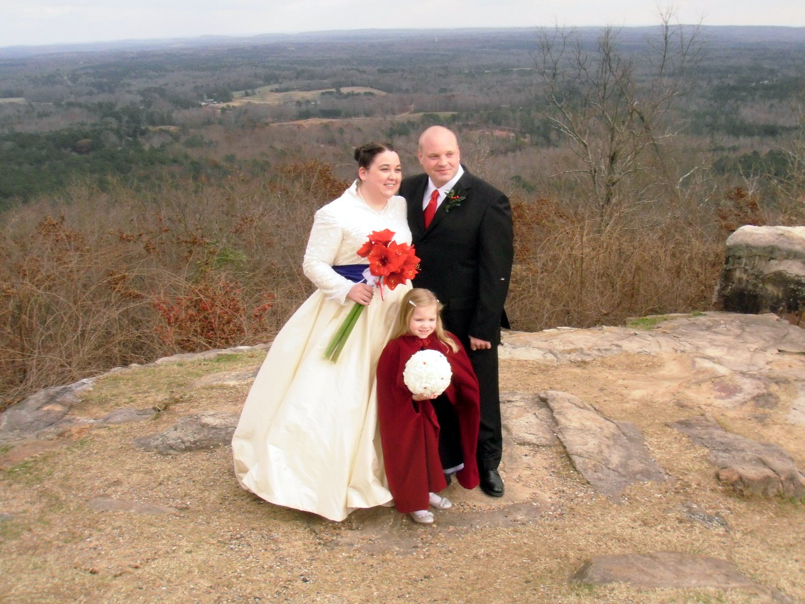
Dowdell’s Knob is so charming and has such an intimate connection with FDR that our daughter Elizabeth chose it as the site of her wedding last December.

The Bride, Groom and Flower Girl at Dowdell’s Knob

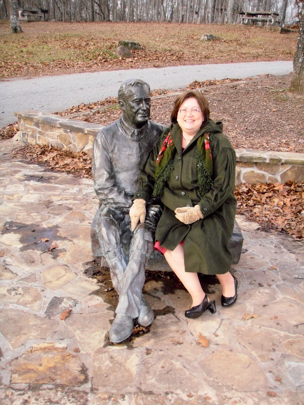
The State of Georgia commissioned a sculpture of FDR to be placed at Dowdell’s Knob, and the artist did a wonderful job of creating an intimate portrait of the man as he was when visiting his favorite spot – comfortable, causal and accessible.

The Mother Of The Bride spending a few moments with Franklin at Dowdell’s Knob. Watch that hand!

I like to think that FDR was there in spirit on the day our daughter was married, sitting in his car, cigarette holder in his mouth, his old comfortable Navy cape around his shoulders, grinning the famous FDR grin as the family gathered by his picnic grill to celebrate. He certainly would have been a welcome presence, since this was his Warm Springs, his Georgia.

– Brian

Which Way North?

Let’s consider the compass.

I was rooting around in an old duffle bag the other day and I stumbled upon the lensatic compass I carried for years in the Army.
The 1986 production Stocker & Yale lensatic compass I carried
during Operation Desert Shield/Desert Storm.
It sits on the 1:250,000 scale map I used while conducing geographic
and soils analysis in the northern Saudi Arabian desert.
It was the results of these reconnaissance efforts that helped convince
General Schwartzkopf and CENTCOM Headquarters that the
famous ‘left hook’ maneuver was feasible.

It is pretty beat up.  It was already used when it was issued to me back in 1989, and I used it a lot in places like Honduras, Saudi Arabia, Kuwait, Iraq, Korea, Panama and across the US.  Like a lot of things military, it is somewhat overbuilt; a big green chunk of aluminum housing a compass. It was one of those pieces of equipment that you forgot about until you needed it, and when you needed it (particularly in places like Iraq or Panama), you needed it bad.  Whenever I opened it and let the compass card swing free I would always let out a little sigh of relief as the arrow settled down and pointed the way north.

My compass never failed, and that is what we should expect of a compass – it should never fail to point the way.  And they rarely do.  That is the absolute beauty of the compass as a navigational instrument.  It is so simple in concept and design that even poorly made examples do just what we ask of them – point the way north.

The compass is the most basic navigation tool and certainly one of the first, if not the first man-made navigation tool.  Before the compass there was… the human eye?  Well, we had maps of a sort, but they are really not direction finding tools.  Humans had spent thousands of years studying the skies with the naked eye, and got pretty good at estimating location, direction, seasons, etc. using the stars.  Certain groups like the Pacific Islanders even got damned good at open water navigation using just the stars, very rudimentary maps (made of woven plant material and shell) and an intimate knowledge of sea conditions and winds.  But what happened when the clouds closed in and the heavens disappeared?  Mankind was lost.  Literally, lost.


What was needed was a device that pointed the way.


The compass is a device so ancient that it’s true origins are all but lost to us, shrouded in history and mystery and claimed by so many civilizations that the real story will probably never be known.  What we do know is that the properties of the mysterious lodestone (the mineral magnetite) were known to multiple civilizations at the same time.  Mostly it was viewed as a magical substance, it’s attractant properties giving it special medicinal powers.  Ancient physicians concocted all sorts of uses for lodestone, claiming it cured everything from skin rashes to the plague.  Even today you can go on Amazon.com and buy bags of lodestones labeled for use in ‘natural healing’ practices.  (Aroma therapy candles and Yanni’s greatest hits, anyone?).  While it is generally acknowledged that it was the Chinese who discovered the direction finding properties of the lodestone, they never matured the technology beyond the most basic design.

A Chinese compass.
A magnetized chunk of iron (shaped like a fish) suspended in a bowl of water.
Simple, yet remarkably effective.
Alas, it seems they never got much past this stage of development.

What is known is that someone, somewhere, magnetized an iron nail or needle with a lodestone and then noticed that the needle acquired magical properties.  The first thing noted is that when suspended by string or floated on water the needle would swing freely and always pointed in the same direction, as though guided by a mysterious, unseen hand.  The next magical property was that it always pointed to the pole star, or Polaris.  At first this phenomena only served to enhance the perception of the magical properties of the lodestone – if it can impart such magical behavior to a simple iron needle then surely, surely, it must be capable of imparting even more wondrous effects to the human body.  Or predicting the future.  Or curing the insanity.  Or defeating enemy armies.  Or…  Well, you pick an application, because folks back in the Middle Ages thought the lodestone was the answer to just about every problem afflicting humanity.


Eventually someone, most likely a seafarer, figured out that if this magnetized needle always pointed north, regardless of the weather, then it could be useful for indicating direction while at sea.  This sharp sailor probably lived along the west coast of Italy in the 13th Century in one of the bustling centers of seagoing commerce scattered up and down the coast, from Genoa in the north to Salerno in the south.  Italian legend attributes the development of the navigational compass to a guy named Flavio Gioia, who lived in a town just outside of Salerno in the early 14th Century.  Scholarship casts serious doubt on this claim, but since nobody has come up with a better story the Italians are sticking with it.  Plus, it’s good for the tourist trade.

Flavio Gioia.
He may, or may not, have developed the compass into a serious
tool for use aboard ship.  But then, he may, or may not, have
actually existed.  Who knows, but it’s a good story
and we’ll run with it!

What is known is that once the navigational compass was developed it’s use exploded across the Mediterranean Sea, and then across the known world.  I have no doubt that hundreds of 14th Century sailors, stepping aboard a ship carrying one of those newfangled compasses and being told that it uses a needle magnetized by a lodestone, smacked themselves on the forehead and shouted “Why didn’t I think of that?”  It was that obvious.

An early Portuguese ship’s compass


The compass is such a simple tool that everything that came after was merely a refinement on the initial design.  Basic refinements came quickly – improvements in indicating direction (development of the compass ‘card’), improvements in mounting and suspeding the needle, improvements in housing the device aboard ship.  The basic compass design was quickly brought ashore and miniaturized, and small and easy to carry compasses began to appear.  For centuries, however, the compass remained a simple device – a needle placed against an indicator that showed the cardinal directions (North, South, East, West, Northeast, Southwest, North Northeast, etc.).   This design seems to have prevailed right up into the 19th Century.

An F. Barker & Son pocket compass from  1858.
One of the earliest pocket compasses I’ve seen that combines both a
traditional compass card showing cardinal directions (N, S, E, W, NE, SE, etc.)
and degree indicators (01 – 360).

What took place in the intervening years was an increased understanding of the properties of magnetisim in general and the magnetic properties of the Earth in particular.  Scientists and experienced navigators had know for years that the magnetic compass didn’t point directly to the pole star, but pointed to the east or west of Polaris depending on where you were in the world.  During the Age of Exploration it was observed that the needle was off a few degrees either direction in most of the northern hemisphere.  In a few places the alignment was perfect – the needle pointed straight north, other places it pointed almost due east or west (particularly at high latitudes), but generally it was just a few degrees off from Polaris.  This fluctuation was not consistent – a scientist or a navigator could not accurately predict what the magnetic difference would be at a future location based on observations at his current location.  Keen observers also saw that the needle itself would not always float horizonally, but would ‘dip’  just a little bit at different locations.  Even more mysterious and concerning, scientists and navigators that returned to the same spot again and again over a period of years noted that the amount of magnetic variation differed.  It was as though something unseen was causing the needle to shift over time.

These observations eventually led to the understanding that the Earth itself is a giant magnet and that the compass needle is not ‘pointing’ north, but the needle is aligning itself with the Earth’s own natural lines of magnetic influence.  This discovery moved the compass from the realm of ‘mysterious instrument’ to ‘well understood tool’.  It also triggered the realization that the compass is a flawed tool, inaccurate and erratic, and to be truly useful for safe navigation its relationship with what we now call true north must be studied, understood and applied.

Rene Descartes (1596 – 1650), French philosopher and physicist
kinda’ sorta’ figured it out back in the early 1600s.

I won’t dive into the details, but Western nations alone or in concert expended huge amounts of money studying the earth’s magnetic properties.  First to apply it to a better understanding of compass accuracy and later to better understand complex geodynamic principles.  (For example, it is the existence of the Earth’s magnetic fields that first led geophyisicists to deduce that the Earth’s core is little more than a huge chunk of iron). The study of magnetisim is still a leading discipline, as scientists work to understand how the Earth’s magnetic field acts as a shield from a lot of the nasty stuff the Sun throws at us, or how a panetary body’s magnetic field can yield enromous information about its interior structure.  Compass users are the happy beneficiaries of a lot of this research, since we now have an intimate understanding of how the Earth’s magnetic field influences our compass bearings.

Yikes!  The Earth’s magnetic field shields us from a lot of
nasty stuff the Sun sends our way.

Today the answer is obvious to us.  The Earth is a giant magnet that has a geographic north and south pole (where the lines of longitude converge) and a magnetic north and south pole (where the magnetic lines of influence converge).  The two don’t match.  In fact, they aren’t even close.  Today the magnetic north pole is located high in the Canadian Arctic about 535 miles south of the geographic north pole, and it is always moving.  The magnetic pole shifts slightly every day in response to influences like solar storms, and over time it drifts – right now it appears to be set to wander over the polar region and settle somewhere in northern Siberia in the next 50 years.

The wanderings of the Magnetic North Pole, 1600 – 2000

While the thought of a wandering pole may cause some readers distress the good news it that we know where its headed and we can accurately track its progress.  If we know precisely where the north pole is located day-to-day we can quickly and accurately calculate the variation between magnetic north and true north for any point on earth.  This calculated difference between magnetic north and true north is known as magnetic declination.

The difference between True North and Magnetic North.
The angular distance between the two poles is what we refer to as magnetic declination.
But why is the south end of the needle pointing North?
Remember your basic principles of magnetism – opposites attract.
The end of your compass needle that indicates North is actually the south end!

In years past governments would periodically publish maps showing lines of magnetic influence, or isogonic lines and include instructions on how to calculate updated declination based on the predicted drift.  However, today you can access one of several web sites that allow you to input your current location and calculate an accurate magnetic declination.  This means you can know precisely the relationship between magnetic north as indicated by your compass and true north, and compensate for declination either directly on the compass or in later calculations.

As far back as 1702 European nations were investigating
and mapping isogonic lines to determine magnetic declination

Knowing the magnetic declination for your location or region and compensating for it is the key step to accurate navigation using a compass!  Once you have mastered this task you can get yourself from one point to the next with confidence.

Whew!  We’ve covered a lot in this posting.  I’ll pause here to let you digest what I’ve presented and to let you do a bit of your own research if you are so inclined.  There are a lot of great resources on these topics available on the web, many of which I’ve linked to in this posting.  Let me add one more link to a NOAA web movie that does a great job of portraying the relationship between the movement of the magnetic poles and the corresponding shifting of the isogonic lines over time.

In the future we’ll take a look at modern compass design and land navigation techniques.

Stay tuned!

Brian