A Man for All Seasons

December 31st is the birthday of one of the greatest Americans of the 20th Century.

George C. Marshall was born in 1880 in Uniontown, Pennsylvania.  He attended the Virginia Military Institute, graduating in 1901 and then competing for and winning one of the few coveted officer commissions reserved for non-West Point graduates.  In virtually every assignment Marshall stood apart from his fellow officers, exhibiting a keen military mind and outstanding leadership traits even as a junior officer.  One of his peers, observing the young Lieutenant Marshall direct what was essentially a regimental-level exercise in the Philippines commented to his wife “Today I watched the future Chief of Staff of the Army at work”.

Few people understand that the US Army didn’t just magically appear on the battlefields of WWII and decisively defeat the Germans and the Japanese.  The foundations of the American Army that won WWII were set years before Pearl Harbor by George C. Marshall.  It started in the trenches of WWI, where a dynamic young Marshall was assigned as the G-3 (Operations) of the 1st Division and later the Assistant G-3 of the American Expeditionary Force (AEF).  Marshall saw first hand the devastation and human suffering caused by a stalemated war that had devolved into static trench warfare, and the effect that poor leadership and poor military decision making had on units and individuals.  He learned those lessons well and carried them with him as he moved up in rank and responsibility.

Between 1918 and 1939 Marshall had a number of assignments that, in retrospect, were key to his success as Army Chief of Staff.  The first was his assignment as Aide-de-Camp to General John J. Pershing.  One of Marshall’s roles in this assignment was in helping General Pershing compile the Army’s official history of its involvement in WWI.  Marshall was able to spend time studying the broader issues that impacted America’s involvement in the war, particularly in the areas of training, leadership, military force structure and industrial readiness.  By this time Marshall was already thinking at the strategic level and he understood that the core issues of WWI had not been settled with the armistice.  He concluded that America would probably be at war again on the European continent within the next 30 years.

Marshall’s next key role came in 1930 when he was assigned as the Assistant Commandant of the Infantry School at Fort Benning, Georgia.  Marshall turned the Infantry School into a laboratory, investigating and testing new tactics and force structures.  Marshall understood that mobility and firepower were the keys to success on future battlefields, and he put sharp young officers like Omar Bradley, Joseph Stillwell, Walter Bedell Smith and Matthew Ridgway to work revamping Army doctrine to reflect this new thinking.  Out of this work came the concept of the smaller, more agile triangular division with more organic firepower, motorization (the horse was about to be left behind), improved communications using the newfangled radio and the integration of armor and air support into a ‘combined arms’ concept.  What is fascinating is that advanced military thinkers in Germany were working along the exact same lines, developing the concept of ‘Blitzkrieg’ – the lightning war spearheaded by fast moving armor forces.

After the Infantry School Marshall was assigned as Commander of the 8th Infantry Regiment in Georgia.  During this assignment he was also appointed as the district military commander for the Civilian Conservation Corps (CCC).  Most military professionals resented being ‘stuck’ with the CCC responsibility by President Roosevelt, but Marshall understood that the CCC would provide vital experience to Army junior officers and NCOs.  In future wars involving mass mobilization officers and NCOs would need experience in routine tasks like receiving, housing, training, feeding, moving, caring for, accounting for and employing large groups of young men.  The CCC role provided just this experience, and Marshall embraced it.

Marshall’s next assignment (1933 – 1936) seemed to him, and his peers, as banishment to the wilderness.  A petty and vindictive Army Chief of Staff, General Douglas MacArthur, had Marshall assigned as the senior advisor to the the Illinois National Guard.  Apparently MacArthur was upset at Marshall’s support of the CCC program (something MacArthur hated and fought endlessly with Roosevelt about).  The politically connected Illinois National Guard wanted a talented Regular Army officer to be assigned as advisor, but National Guard advisor positions were viewed by the Regular Army as something second-tier officers got stuck with.  MacArthur saw this as an opportunity to placate the Illinois politicos and send Marshall a message.  In typical Marshall fashion he made full use of the assignment, evaluating the National Guard from the inside, developing a keen understanding of their training and readiness and mapping out the political sub-structure that supported the National Guard systems in most states.  This understanding would be critical when Congress federalized all National Guard units for integration into the Regular Army after Pearl Harbor.

After the National Guard advisor position Marshall was promoted to Brigadier General and went on to command the 5th Infantry Brigade in Washington State and more CCC involvement.  By 1938 the threat of war in Europe was again looming and Marshall’s talents were finally recognized at the national level.  He was pulled to Washington D.C. to head the War Plans Division.  In 1939, on the recommendation of the outgoing Army Chief of Staff General Malin Craig, Marshall was promoted to four star rank and appointed Army Chief of Staff by President Roosevelt.  I consider it one of Roosevelt’s most prescient moves that he recognized Marshall’s talents and promoted him over dozens of other Army general officers with more seniority.

Finally, George C. Marshall’s experience and skills were turned to what he had been anticipating, yet dreading, since 1918 – preparation of the US Army for global conflict.  With the foundations in place and solid support of the President, and Secretary of War Henry Stimson, Marshall set in motion his plan to prepare the Army for modern war.

The new Chief of Staff understood better than anyone that the next war was going to be fought by young Americans who were not just citizen soldiers, but they were the sons and husbands of American citizens and as such deserved to be led by the very best.  Yes men would die, but they should not die needlessly or because of a failure of leadership or training.  It was the Army’s responsibility to provide the very best officer and NCO leadership and training possible.  Towards that end, Marshall cut a wide swath through the Army, firing or retiring hundreds of senior officers who were too old, too out of shape or just plain incompetent.  (One politically dangerous move was his firing of virtually all National Guard division commanders soon after their divisions were federalized.  He realized from his National Guard advisory experience that these commanders were little more than political hacks and were not up to commanding divisions on the modern battlefield.)  At the same time Marshall reached down into the Regular Army officer ranks and pulled up dynamic young men he knew could perform.  Virtually overnight talented officers like Omar Bradley, Mathew Ridgway, Mark Clark, Walter Bedell Smith and Dwight Eisenhower found themselves jumping rank and position on the fast track to senior command or staff positions.  As an example, in early 1941 Omar Bradley was promoted directly from Lieutenant Colonel to Brigadier General, bypassing the rank of Colonel.  A year later he wore two stars and was commanding the 82nd Infantry Division (before it was designated an airborne division).  If General Marshall knew you and you measured up to his exacting standards you could expect fast promotions and increased responsibility.

General Marshall also revolutionized the Army machinery that created small unit leaders.  Prior to 1940 you could still become an Army officer by direct political appointment or even election or acclimation by members of the unit (this is how Harry Truman got his commission in WWI).  While this system only existed in the National Guard system at the time, it was still viewed as a viable method of obtaining a commission.  Marshall put an end to all that and standardized policies and procedures for obtaining officer rank in the Army.  He also knew the Army’s demand for unit leaders at the platoon and company level would be almost insatiable and the existing commissioning programs, West Point and ROTC, would not meet the demand.  Marshall also knew that the Army already contained a vast pool of potential officers – the enlisted ranks.  Every day thousands of young men were volunteering or were being drafted who had some college experience and would make excellent officers.  Marshall directed the establishment of the Officer Candidate School (OCS) program at Fort Benning.  Following a curriculum developed by General Omar Bradley the OCS program took talented and educated enlisted men and turned them into Second Lieutenants.  This program was so successful that it became the primary commissioning source for the US Army in WWII – far surpassing the numbers of officers generated out of West Point and the college-based ROTC programs.

Even as Army Chief of Staff, General Marshall never lost focus on or sight of the individual soldier.  Immediately after Pearl Harbor his advisors notified him that no more silk would be imported due to the war with Japan (the world’s major producer of silk).  Silk was now classified as a strategic material and it was up to Marshall to determine how the Army’s share of it would be used.  There was a lot of demand for silk – for use in uniform neckties, socks, flags, pennants, even as powder bags for artillery ammunition – and it was clear the available supply would not last long.  Marshall directed that the available silk be reserved for just two uses – as parachutes and as award ribbons.  The General understood that award ribbons were important to the soldier.  They were (and still are) the Army’s visible recognition of service and valor, and those little bars of silk would end up meaning a lot to the millions of soldiers just entering military service.  Award ribbons made of dyed cotton or wool look like junk compared to silk, and Marshall knew that.  The soldier deserved the best, and only silk would do for this important purpose.  With the development of nylon for use as parachute canopy material early in the war virtually the entire Army stock of silk ended up being used for the production of award ribbons.  General Marshall knew it would be important to the common soldier, so it was important to him.

George C. Marshall, like Cincinnatus, wanted nothing more than to retire and live out the rest of his life as a gentleman farmer and historian.  On November 18th 1945 he retired as Chief of Staff of the Army and he and his wife fled to their small estate in Virginia.  The most powerful military figure in the world finally found peace and pleasure in puttering around his house, painting shutters and planting shrubbery.  Less than ten days later he received a personal phone call from President Harry Truman asking him to become his ambassador at large and travel to China to try to untangle that growing mess.  Marshall’s sense of duty would not allow him to say no, and he was launched on his second career as diplomat, Secretary of State and father of the Marshall Plan which financed the reconstruction of Europe and ensured that Western Europe remained free of Soviet domination.

George C. Marshall died on October 16th, 1959 at Walter Reed Hospital in Washington, D.C.  I have been told that at the announcement of his death grown men, many of them with stars on their collars, broke down and cried.

In my estimation George C. Marshall is the key figure in the story of America’s success in WWII.  General Marshall is the reason we fielded the excellently trained, equipped and led armies we did between 1942 and 1945.  More than any one person he was the architect of America’s victory in WWII and shaped the free world that came after.

He was the indispensable man.  The man for all seasons.

– Brian

The Pocket Transit

In Which Way North? (Part I) we discussed the history of the magnetic compass and talked a bit about magnetic declination.  Now let’s start looking at some specific compass designs and discuss why they were important.

To start we’ll look at a compass design that is uniquely American and was born of the late 19th Century explosion of mining and mineral exploration in the US.  This compass was originally conceived to fit a very specific need, but it was so well designed and executed that it found use in a wide variety of applications and industries.  It continues to be produced today, over 100 years since its introduction and little changed from its original design.

The Brunton Pocket Transit was patented in 1894 by David Brunton, a Colorado mining engineer.  Brunton was frustrated by the number of survey instruments a mining engineer and geologist had to carry around with him (and I say ‘him’ because mining engineering and field geology was an exclusively male profession well into the 20th Century).  In the late 1800s it was not unusual for engineers and geologists doing basic exploratory mineral mapping to lug around full sized survey transits, surveying compasses, tripods, clinometers, and plane tables. These instruments offered a high level of accuracy that simply wasn’t needed for exploratory surveys.  As an engineer himself Brunton realized that what was needed a portable device that allowed field survey personnel to do fast and accurate exploratory quality surveys without being burdened down by equipment that was heavy, expensive and difficult to set up and use.  These men were in the business of discovering, verifying and mapping mineral deposits that covered vast areas.  Huge sums of money were at stake as mining and mineral companies scrambled to secure valuable leases on the stuff that was fueling America’s exploding industrial economy – timber, gold, silver, coal, iron ore, chromium, nickel, bauxite, petroleum and dozens of other minerals that were key to America’s growth.  Field engineers and geologists needed to move fast, do rough mapping and get that information back to the office for the development of lease maps and boundary descriptions.  They didn’t need to be burdened with heavy, sensitive and fragile survey gear if that level of accuracy wasn’t required.  David Brunton recognized the problem and set to work developing a solution.

What Brunton came up with as a pocket-sized device that incorporated an accurate magnetic compass with a sighting vane, a clinometer, a level and a large mirror with a sight line.  Housed in a machined aluminum case (still an expensive material in the late 1800s), it was rugged, reliable and useful.

Brunton named his instrument the ‘Pocket Transit’, a lofty title for a fairly rudimentary mapping device.  But the name served its intended purpose; in the mind of the engineer and geologist it set the device apart from the common handheld compass.  Here was a professional instrument that offered a level of accuracy and functionality not found elsewhere.

Brunton’s 1894 model Pocket Transit

Brunton had more than marketing on his side.  The Pocket Transit actually delivered where it mattered – in the field and in the hands of engineers and geologists across North America.  It delivered all the functionality and accuracy needed to get the job done.  It ended up being the perfect device for the job at hand.

Demand for Brunton’s device increased steadily and improvements were introduced.  An additional bubble level and a cover mounted peep sight were added in 1912.  In the same year Brunton introduced modifications to the case that allowed mounting the instrument on a non-magnetic tripod or jacobs staff.  (It’s interesting that in his 1894 patent application Brunton derided other compass designs that needed to be tripod mounted, but in the 1912 patent application he discusses tripod mounting like it’s the greatest idea since sliced bread.)  Somewhere between 1894 and 1912 the Pocket Transit acquired the ability to pre-set magnetic declination by use of an adjustment screw on the side of the case.  By 1926 Brunton’s design had fully matured with the addition of a bullseye level for improved leveling and the addition a percent grade scale to the clinometer.  From this point forward it was minor improvements in materials, manufacturing techniques and the added availability of different compass ring layouts (degrees, quadrants, mils, etc.)

A 1926 patent model of the Brunton  Pocket Transit.
Note the round level and the percent grade indices
at the bottom of the clinometer scale.  This is the basic
design still in production today.
One of the reasons Brunton’s pocket transit was
so damned useful is that he made it a complete package.
Early in the production of the pocket transit Brunton started
engraving sine and tangent tables on the lid.  Using these
tables in conjunction with the clinometer an engineer could
quickly and accurately determine heights of objects like trees
or cliff faces.  To this day Brunton includes the sine and
tangent tables on the lids of all pocket transits.
So damned useful!
From the beginning David Brunton licensed the Colorado instrument maker William Ainsworth & Sons to produce the pocket transit.  After Brunton’s death in 1927 Ainsworth purchased the manufacturing rights to Brunton’s designs and continued manufacturing and improving the Pocket Transit through the late 1960s.  In 1972 the production rights and the Brunton name were purchased by the Brunton Company of Riverton, Wyoming.  The Brunton Company continues to manufacture this basic design.

The Brunton design was so well thought out that engineers and geologists quickly developed field techniques keyed to the Pocket Transit’s unique layout and construction.  The best example is the determination of the strike and dip of rock formations.  Most sedimentary and metamorphic rock formations are not horizontal.  They were all deposited in horizontal layers but over geological time (i.e., millions of years) those horizontal layers have been warped and deformed by pressure and other geological forces.  One of the keys to understanding these forces is mapping the strike (the horizontal angle of deformity) and dip (the vertical angle of deformity) of individual rock layers.  Before the Brunton Pocket Transit the measurement of strike and dip was a clumsy process involving two separate devices – a field compass (often a fairly large and somewhat fragile device) and a clinometer.  With the Brunton the process is quick and simple – open the instrument and lay it horizontally against the rock formation.  Keeping the edge of the instrument in contact with the rock face rotate it up and down slightly until the circular level is centered.  Note the magnetic azimuth as indicated by the compass needle.  That is your strike.  Score a line on the rock face horizontal to the pocket transit using a piece of chalk or small piece of rock and remove the pocket transit.  Make another score mark that is perpendicular to the horizontal mark you just made (your mark should look like a ‘T’).  Place the Pocket Transit along this perpendicular mark and measure the angle of slope using the built in clinometer.  This is your dip.  It takes longer to describe than it does to do it in the field.  This is the standard measurement technique for strike and dip, and every college and university geology department in North America teaches it as part of their field geology curriculum.

From the University of Calgary website.  Measuring the strike
of a rock formation using a Brunton Pocket Transit.
From the University of Calgary website.  Measuring the dip of
a rock formation using the Brunton Pocket Transit.
My introduction to the Brunton Pocket Transit came in the mid-1970s while studying geology in college.  We learned strike and dip measurement techniques early on in the field methods class, and later during our summer field geology course we ranged across the southwestern United States, making thousands of strike and dip measurements in an effort to understand the geologic processes that formed the unique landscape of that region.  I saw the Pocket Transit as a useful but fairly limited device, suited only to the field geologist.  Years later while attending a course at the Defense Mapping School at Fort Belvior, Virginia, our class got an intensive block of instruction on the use of the Pocket Transit not just for strike and dip measurement but for height determination, precise azimuth determination, basic plane table survey work and rough site layout.  I finally saw the full potential of the Pocket Transit and purchased my first one soon after.  That Pocket Transit has seen service in Kuwait, Honduras, Panama, Germany, Bosnia, Korea and across the US.  It has been a constant companion on hundreds of field surveys, assisting with tasks like mapping out refugee camps on the Empire Range area of the Panama Canal Zone, measuring road grades along the Pan-American Highway in Honduras and fixing North Korean observation point locations along the Korean DMZ.

The Brunton Pocket Transit doesn’t measure horizontal angles as well as a conventional transit, it doesn’t measure vertical angles angles as well as a theodolite, sextant or even an Abney hand level.  If you need to shoot azimuths using handheld techniques the Army lensatic compass is a better tool.  However, the Pocket Transit does all of these tasks well enough, and puts everything needed into a compact, easy to carry package that really does fit into your pocket.  (In his patent application David Brunton noted that the instrument fits nicely into a vest pocket – therefore the name pocket transit).

Let’s have a look at some Brunton Pocket Transit variations (click on the pictures for an enlarged view):

This is a modern incarnation of the Pocket Transit – a glass filled composite
body version.  This particular Pocket Transit is almost 20 years old
and has been used around the world, and it still looks new.
This is a particularly nice WWII era Pocket Transit manufactured in 1943.
This model is graduated in mils (6400 mils in a circle).  Designated the
M-2 Compass, it was designed for use by artillery troops who need a more
discreet subdivision of the circle for accurate artillery gun laying and spotting.
A variation of this model is still used by the US Army and USMC today.
An early induction dampened model graduated in degrees
A nice post-war model graduated in quadrants instead of degrees.
Most early Pocket Transits were sold with the quadrant setup rather than
degrees.  The use of quadrants was the accepted method of noting direction
within the engineering and geology community up through the 1970s.  Brunton
still sells a modern version of this layout, but it really is useless for general
navigation purposes.  If you want to do land navigation with a Pocket
Transit get the model laid out in degrees!

As you can tell, I think the Brunton Pocket Transit is a nifty little tool.  But it is not a novelty, not something to be put on a shelf to be admired.  The Pocket Transit is designed and built to be used.  It represents American ingenuity at its best.  From 1894 on the Pocket Transit ended up being used in all corners of the United States, doing useful, often rough duty helping to map American and her natural resources.  Rugged, reliable, useful.  American to the core!

Brian

In writing this blog post I relied heavily on several sources that I feel need to be acknowledged.

First is William Hudson’s excellent website About Brunton Pocket Transits.  Mr. Hudson’s site is the most complete compilation of information about Pocket Transits on the web, and should be the starting point for anyone interested in finding out more about these great little devices.  Thanks you Mr. Hudson.

Next is Dr. Peter H. von Bitter’s article The Brunton Pocket Transit, A One Hundred Year Old North American Invention.  Originally written in 1995 for the journal of the History of the Earth Sciences Society to celebrate the 100 year anniversary of the invention of the Brunton Pocket Transit, von Bitter’s article forms an excellent short history of the man David Brunton and his famous invention.  Thank you Dr. von Bitter.

Although not source, there is an scanned copy of a 1913 Ainsworth bulletin available on the the Surveying Antiques website.  This bulletin describes the various ways to hold and use the Pocket Transit and is an interesting overview of the instrument and its uses.

US Army FM 21-26

An Army field manual as a book of the month?  Just how interesting or relevant or important can a field manual be?

Well follow along, because for certain groups of people this FM is very interesting, relevant and important.

FM 21-26, Map Reading and Land Navigation is the Army’s map reading and land navigation handbook.  This manual has been in continuous publication and upgrade since 1941.  The current edition is dated 2005, with changes posted in 2006.  As part of a sweeping Army field manual re-designation the manual has been renamed FM 3-25.26*.  Regardless, it is still commonly referred to as FM 21-26, and that’s how we’ll refer to it here.

The Army seems to have adopted standard map reading and land navigation practices back in 1939, and published its first series of map reading and land navigation manuals in early 1941 (FM 21-25, Elementary Map and Aerial Photograph Reading and FM 21-26, Advanced Map and Aerial Photograph Reading).  Prior to 1939 map reading and land navigation was viewed almost as a black art, covered in non-standard texts targeted at officers and emphasizing field sketching and rudimentary survey as much as map reading and navigation.  A large part of the problem was that the Army had no map standards or centralized map production, so providing maps for unit operations was a local commander’s headache.  If you were a regimental commander and wanted a map of an area you put your regimental engineers to work either finding suitable maps from local or commercial sources, or you had them drawn up from field sketches or plane table surveys.

Army leaders realized that in the looming global war the old ways of producing and using maps would not do.  The Army needed dedicated map production assets that could produce millions of maps using common symbols, colors and scales.  This led to the creation of the Army Map Service and the standardization of map production on a global scale.  Once you had map standards in-place and maps in production you could develop standardized map reading and land navigation practices using these new maps.  FMs 21-25 and 26 were the result of that effort.  Finally, the Army had standardized map reading and land navigation texts it could use to train the millions of Soldiers about to be drafted into the Army to fight WWII.

After WWII, the establishment of NATO and the US Army’s realization that it would still maintain global warfighting responsibility the two field manuals were combined into one – FM 21-26, Map Reading, published in 1956.  The significant change in this manual was the introduction of the Military Grid Reference System (MGRS) based on the Universal Transverse Mercator (UTM) coordinate system.  The development of UTM and MGRS signified a revolution in mapping and mapping grids.  For the first time an army had an accurate low distortion world-wide grid system suitable for large scale mapping.  With MGRS and using just a paper map and a simple protractor a Soldier could uniquely identify his position anywhere on the face of the earth to within 10 meters.  MGRS is accurate, easy to teach, easy to use and virtually ‘soldier-proof’.

Updates to FM 21-26 came out every few years and the major changes seem to have been the simplification of basic principles and techniques, and the dropping of out-of-date or no longer needed procedures (like interpreting hatching to indicate landforms or the use of obsolete equipment).

Today’s FM 21-26 is map reading and land navigation distilled down to the basic, easy to learn and easy to execute functions.  It is not just map reading, but it is also the use of map substitutes (mainly aerial and satellite images), dead reckoning, field expedient direction finding, basic orienteering, terrain association and basic field sketching.  One key item of note is the Army’s method of teaching how to determine the magnetic to grid declination factors.  The lesser or greater angle method is hands down the easiest way to manage this often confusing issue.

Sure, FM 21-26 has a military focus.  It is, after all, an Army field manual.  The book spends a lot of time discussing the use of the MGRS system, how to orient, plan and navigate using MGRS.  It’s MGRS, MGRS, MGRS.  For years civilian students of map reading and land navigation had no use for this portion of the manual.  Topographic maps of the US either had no grids or had grids different than the MGRS grid, and US-based maps were printed at scales different than those used by the military.  This has all changed.  In just the past few years the US has (finally!) adopted what is known as the US National Grid.  The US National Grid is now being implemented for all USGS (US Geological Survey) large scale (1:24,000 and 1:100,000) topographic line maps, and the USGS is rushing the new US Topo series of maps into production.  So what is this new US National Grid?  It is nothing more than MGRS implemented for all USGS topgraphic maps of the US.  Remember, MGRS has always covered the world, but the US military does not produce maps of the US – that’s the job of the USGS.  The MGRS grid template always existed for the US, but the USGS never adopted it.  Until 2008, that is.  Driven by homeland security and disaster relief coordination concerns the USGS formally adopted MGRS, known as the US National Grid in the US, and is now producing maps to that standard.

Suddenly the discussion of MGRS in FM 21-26 becomes very relevant.  All the MGRS-based map reading techniques can now be directly applied (and are intended to be applied) to the new USGS topographic maps.  The only remaining issue is that of scale.  The US military produces large scale maps at 1:50,000 while the USGS produces large scale maps at 1:24,000.  While all the MGRS techniques apply to USGS maps, you can not use the standard map protractor (GTA 5-2-10) discussed in FM 21-26 since it does not have a 1:24,000 plotting scale included.  This isn’t a real problem because a number of manufacturers offer MGRS/US National Grid plotting scales for use with 1:24,000 scale maps.  One of my favorites is the Super GTA tool produced by Maptools.com.

Another great thing about FM 21-26 is that it is one of the few Army field manuals authorized for unlimited release.  This means the Army retains the copyright to the manual, but users are free to copy, reprint and distribute it without penalty.  As a result you can find free downloads of FM 21-26 all over the web and you can purchase inexpensive printed copies from retailers like Amazon.com.

So, if you like maps, are interested in map reading and land navigation, or have just a passing interest in these topics go get yourself a copy of FM 21-26!

– Brian

*The new designation of FM 3-25.26 seems a little unusual in the overall scheme of revised manual numbering.  I’d like to think that someone in TRADOC with a respect for military history recognized the significance of the original series of manuals, FM 21-25 and FM 21-26, and as a nod to tradition decided to redesignate the new manual as FM 3-25.26.

A Date That Will Live In Infamy

We didn’t ask for it, didn’t instigate it and didn’t want it.


But three years and eight months later we sure as hell finished it.


My salute to those that served on that fateful day in December, 1941, and to the millions that followed them into battle around the world to give us the liberty and prosperity we enjoy to this day.

Lasting Impressions

Roberta and I were having lunch today in our favorite BBQ joint (Cafe Pig in Peachtree City, Georgia). As we were talking I looked up at the bric-a-brac on the wall and noted a copy of a painting of Franklin Delano Roosevelt. It was the painting that was being worked on the day of his death in Warm Springs, Georgia – April 12, 1945.

Unfinished Portrait of FDR by Elizabeth Shoumatoff. FDR was sitting for this portrait at Warm Springs on April 12, 1945 when he complained of a terrific headache and then collapsed. He died later that day of a cerebral hemorrhage. A copy of the painting still sits in an artist’s easel in the living room of the Little White House, as though waiting for the subject to come back to finish the sitting.

Roosevelt was a blue blooded patrician from the Hudson River Valley, a member of an extensive family that traced its roots back to the earliest Dutch and Huguenot settlers to establish a foothold in the New York region. One of his cousins, and his personal hero, was Theodore (Teddy) Roosevelt, Assistant Secretary of the Navy, commander of the Rough Riders in the Spanish American War, Governor of New York and later the 26th President. Born into privilege and wealth and blessed from birth with family connections that could have carried him anywhere in the Republican political world, FDR chose instead to run as a Democrat. In his first political foray in 1910 – a run for New York State Senator – he sensed correctly that Democrats were poised to take control of the New York statehouse. This began his lifelong political career as state senator, Assistant Secretary of the Navy, Governor of New York, vice-presidential candidate, Governor of New York and, ultimately, US President.

FDR’s life history is one of the better known and studied among US presidents, and for good reason – the length of his presidency (12 years), his personal struggles with polio, his efforts to pull the US out of the Great Depression, his struggle to maintain neutrality in the face of mounting world crisis and, ultimately, his leadership in WWII all leave plenty of rich pickings for historians. FDR also had the good fortune of being in office just as broadcast radio emerged as a reliable and widespread communications medium, and he used it skillfully to take his message directly to the American people. For many Americans in the 1930s FDR was the first President they ever heard speak live, and through radio they heard him often. That high, nasal patrician voice gave comfort and reassurance to millions of Americans struggling to just survive.

FDR was an extremely skilled politician, manipulator and chameleon. He played his audiences like a finely tuned musical instrument, and he was rarely off key. It has been said that an FDR appearance was like grand theater, and when you met him one-on-one and got the ‘full Roosevelt treatment’ you came away awed by the experience and the man. It also left historians with a treasure trove of radio broadcasts and newsreel footage with which to balance the often dry recitation of a presidential administration as evidenced by the paperwork it left behind. Unlike any President that came before, the modern media of radio and film allowed Americans to view the President as a human being, not a figurehead.

Yet I am of two minds when it comes to the FDR as president. I greatly admire his foresight and leadership in WWII. His early (and probably illegal) efforts to skirt the US neutrality laws ensured that Britain survived until America’s entry into the war. FDR also brought the full weight of his political and diplomatic skills to bear on pre-1941 efforts to expand and modernize our armed forces in preparation to face what he saw was America’s inevitable involvement in WWII. I don’t think any other president could have done a better job.

On the other hand, his undisciplined tinkering with the US economy and his administration’s abandonment of free market principles certainly extended the Great Depression. Everything his administration did between 1933 and 1940 only served to stifle US economic growth. Many economists today reluctantly admit that had Roosevelt simply left the economy alone and allowed the free markets to correct themselves the economy would have rebounded much faster than it did. In the end it took a world war to pull us out.

FDR also kicked off an expansion of the federal government that continues unbridled to this day, although I’m sure he would be appalled at just how big, how far reaching, how intrusive and how liberal the government has become.

But all this is neither here nor there in relation to today’s posting. Our lunch today reminded me of the the impressions FDR directly made on the State of Georgia. When you travel through west central Georgia, from just south of Atlanta to Columbus, you travel through FDR territory. The story of FDR’s legacy in Georgia is one of the fascinating back-stories of history.

In 1921 FDR was struck down by polio. His search for a cure, or even moderate alleviation of his symptoms, led him to the resort of Warm Springs just outside of Pine Mountain in Georgia. At the time he discovered Warm Springs in 1926 it was a small resort that had seen better days. Using his personal fortune and political influence he built Warm Springs into a leading hydrotherapy treatment center (and it remains a leading paralysis treatment center to this day).

But to FDR it became much more than just a place to find a cure. He fell in love with Warm Springs and the Pine Mountain area. It was a place where he could find relief from the pain and crippling effects of polio, where he could work his personal magic by encouraging fellow paralytics and where he could be himself without any pretensions. He wasn’t ‘Governor Roosevelt’ or ‘President Roosevelt’ to the hundreds of kids who came to Warm Springs for treatment. He was simply ‘Mr. Franklin’, a fellow polio victim who encouraged them, cajoled them, played with them in the pools, shared their joy when treatments worked, kept their spirits up when treatments failed. He helped pay for their therapy, sponsored parties and picnics, took them on drives through the countryside and up into the mountains. He was one of them, in body and spirit.  Many observers noted that at Warm Springs FDR was truly himself.

FDR was so in love with Warm Springs that in 1932 he built a cottage there that became known as the Little White House. This is where FDR stayed whenever he was in Warm Springs. Significantly, Eleanor Roosevelt hated the place and only visited once or twice. This meant that the Little White House became a place of solace and refuge for FDR. It is where he went to escape the pressures of the Presidency and WWII.

FDR’s Little White House, and it is little!  Three small bedrooms, a small kitchen and a living room, but a wonderful porch with a great view. It is amazing to think FDR would run the country from this small cottage for weeks at a time.

But FDR did more than just drop in to Warm Springs and the Little White House for treatment. He was too much of a politician to just soak in a pool for a few hours. He needed to get out and get around, see what the people are doing, get their stories. He had a compulsive need to press the flesh.  And he did it from the driver’s seat of his car.

FDR would roam Meriwether County, driving his specially modified Ford. He would stop and talk to local farmers, sharecroppers, laborers, store keepers, politicians, anyone who wanted to chat. White or black, it didn’t matter. He would listen to their problems, issues and concerns, and he turned much of what he learned from those conversations into programs through New Deal legislation. FDR’s roamings were so extensive that even today it is easy to find people around Pine Mountain and Warm Springs who remember being held up by their parents as they chatted with the President or climbed on the running boards of his car as he stopped in town. It seems at one time or another about half the residents of Meriwether County claimed to have spoken with, had lunch with or had a drink with Franklin Delano Roosevelt.

Recently I went fishing with a group of friends on the Flint River which runs close to Warm Springs. Our guide told us the story of his grandfather, a county official back in the late 1930s, who was out with a road maintenance crew one day when FDR, driving alone, raced up to the group and came to a sudden stop. “Jack, is that you?  Jack, I’m looking for some whiskey and I know you can tell me where to find some!”  Jack, our guide’s grandfather, had met FDR during some of his previous outings and gave the President quick direction to a local moonshiner’s house. As FDR pulled away he gave a wave and with the characteristic FDR grin shouted, “Boys, I’d like to stay and chat, but my Secret Service detail is right behind me and I don’t want them to know what I’m up to!”  And with that the President of the United States sped off down the road in search of illegal whiskey. Moments later a convertible full of Secret Service agents raced by as the maintenance crew pointed down the road in the direction they sent the President. A true story? Who knows, but it reflects the relationship the region had with the 32nd President – a rich and powerful yet friendly and unpretentious character who needed Warm Springs as much as the town and region needed him. The two came to love each other, and Warm Springs and Pine Mountain claimed FDR as one of their own.

While the Pine Mountain region is rich with stories of FDR, he also left a physical legacy. First and most important is the Roosevelt Warm Springs Institute for Rehabilitation. The institute continues to operate today, providing treatment and support for up to 5,000 patients a year. Next is the Little White House. When Roberta and I visited it a few years ago I was very surprised to learn that the Little White House and surrounding grounds are not part of the National Park system. The property is owned by the Warm Springs Institute and is run by the Georgia Department of Natural Resources. The Warm Springs Institute maintains the house as it looked the day FDR died. It is easy to see why FDR loved it so much – it is a small and unpretentious structure, comfortable and comforting.

Even more personal for our family is a location called Dowdell’s Knob on Pine Mountain. The knob offers a beautiful view into the King’s Gap region of Pine Mountain, and the location was one of FDR’s favorites. It became his favorite picnic spot and he had a stone picnic grill built there for his personal use. Dowdell’s Knob is also one of the last places FDR visited, stopping there just two days before his death to spend some quiet moments alone before heading back to the Little White House and the war business that awaited.

Dowdell’s Knob is so charming and has such an intimate connection with FDR that our daughter Elizabeth chose it as the site of her wedding last December.

The Bride, Groom and Flower Girl at Dowdell’s Knob

The State of Georgia commissioned a sculpture of FDR to be placed at Dowdell’s Knob, and the artist did a wonderful job of creating an intimate portrait of the man as he was when visiting his favorite spot – comfortable, causal and accessible.

The Mother Of The Bride spending a few moments with Franklin at Dowdell’s Knob. Watch that hand!

I like to think that FDR was there in spirit on the day our daughter was married, sitting in his car, cigarette holder in his mouth, his old comfortable Navy cape around his shoulders, grinning the famous FDR grin as the family gathered by his picnic grill to celebrate. He certainly would have been a welcome presence, since this was his Warm Springs, his Georgia.

– Brian

Things of Global Importance – The US National Grid

OK, everybody get on  your beanie hat with the spinny propeller – it’s uber dork time.

As I continue work on my PowerPoint opus magnum on magnetic declination I’m becoming reacquainted with issues, concepts and developments I never paid much attention to in my years of work in the topographic field.

One of these developments is the US National Grid System. (Hey, I warned you this was going to be a dorky post.)

Huh? The US National Grid System?

While the US Geological Survey (USGS) has done an outstanding job of mapping the US at large scales (1:24,000 and 1:100,000) there has never been an ‘official’ map grid system selected for use on US topographic maps. For decades USGS maps have sported both Universal Transverse Mercator and Latitude/Longitude grid tics, in sort of a ‘we can’t make up our minds, so we’ll give you everything’ approach. Problem is that the UTM grid system, while accurate, is clumsy and somewhat difficult for the average hiker, Boy Scout or search and rescue team member to use. Soooo many numbers, and little numbers and big numbers, and some numbers that are repeated, and numbers going north have more digits than the numbers going east. Plus, you have to draw your own lines to connect the tic marks and create your own grid. It’s all so confusing.  And cumbersome.  And unnecessary.

Waaaaay back in the late 1940s the US Army got it figured out, and created the Military Grid Reference System (MGRS). MGRS was (and still is) a map grid system based on the UTM coordinate system, but it is greatly simplified so that a soldier can locate himself with an alphanumeric designator that uniquely describes his position anywhere in the world. The Army extended this standardized coordinate system around the globe (including the US) and over the years has produced hundreds of millions of maps using the MGRS coordinate system. Along the way the Army simplified and standardized map reading techniques using MGRS in conjunction with coordinate scales and compasses, published one of the premiere texts on map reading and land navigation (FM 21-26) and proceeded to teach millions of Soldiers, Marines and the occasional Sailor and Airman the finer points of map and compass work.

Unfortunately the USGS never followed the Army’s example. With only minor exceptions, USGS 1:24,000 scale topographic maps remained grid-less. Users were left to draw their own grids on their maps and figure out the maddening complexity of the UTM coordinate system.

Aaah, but the times, they are a-changing! Recognizing the growing need for a comprehensive national map grid system and spurred, I’m sure, by the post 9/11 drive for standardization and interoperability in national, regional and local disaster response efforts, the USGS has adopted a national map grid system. After much study, conferencing, research, investigation and consideration the USGS took the bold step of….  simply adopting the US Army’s Military Grid Reference System. Now, this is not a bad decision. In fact, it’s a great decision, but geezus guys, you could have done this like, oh, the middle of the last century!

But let’s give credit where credit is due. Once the USGS decided to adopt the US National Grid System they jumped on it like a duck on a junebug. All maps produced under the new US Topo series will incorporate the US National Grid System, will have the full grid overprinted on the map, and legend information will include the full USNG grid identification diagram.


The great news is that if you remember your old Army map reading instructions, the US National Grid System works exactly like the Military Grid Reference System – heck, it is the Military Grid Reference System*, just implemented at a different scale (1:24,000 vs. 1:50,000). All the old rules are the same – remember to include the Grid Zone Designation and the 100,000 meter Square ID. And don’t forget to read right and up!

The best way to learn to use the new US National Grid System is to download the Army’s classic field manual on map reading and land navigation, FM 21-26. This FM is approved for public release so feel free to download it and study it. While the mechanics of map location are the same between grid systems, just remember that the scales are different. You can also download and print a US National Grid practice map (shown above) and a 1:24,000 coordinate scale from the Federal Geographic Data Committee US National Grid website.

So, your homework for this week is to download FM 21-26, the practice map and a coordinate scale and practice, practice, practice. There’ll be an exam next week!

Brian

*OK, MGRS and the USNG are not exactly the same, but close enough that the difference doesn’t matter.  MGRS is built on the WGS 84 datum and the USNG is built on the NAD 83 datum.  The ground difference between these datums are roughly 1 meter.  For land navigation purposes this difference doesn’t really matter.  Hey, once again, I told you this was going to be a dorky post!

Maps, Maps and More Maps

I want to place this post under the subcategory of “Best Use Of My Tax Dollars.”

The US Geological Survey (USGS) has the stated mission of mapping the United States. That was one of the foundational roles of the USGS, and it is a role they took on with an almost missionary zeal from the beginning (the USGS was created in 1879 by act of Congress).

USGS set the standard for large scale (i.e., small area) mapping, and their 1:24,000 series topographic maps of the United States are classics.  These are the 7.5′ x 7.5′ quadrangle sheets, commonly known as ‘quads’.  These quad sheets have been used to teach generations of Americans the basics of map reading, terrain association and land navigation.  They have guided millions of hikers,  orienteers, foresters, researchers, explorers, search and rescue personnel, hunters, fishermen, campers and canoers for over 100 years.  USGS maps have, literally, served as the background to America’s love of the outdoors and her expansion and growth across three centuries.

In the old days about the only way to get USGS topographic maps was to order them directly from the USGS or purchase them from a limited number of authorized sales outlets like camping supply stores.  You can still do that if you like – a single USGS 1:24,000 map will run you about $8.00.  Not cheap, but not bad for a high quality map printed via lithographic processes.

But this is the age of the World Wide Web, instant gratification and free data.  The USGS has happily obliged us by putting virtually its entire inventory of topographic map products – at all scales – on line for instant download.  The USGS online store offers an easy to use map search function under the Map Locator link.  You can search for a particular map by address, place name or simply by picking a point in the map in the Google Map window.  Using this process you can either purchase the paper map or download a free digital copy.  The free digital map is a scanned copy of the original paper map in Adobe PDF format.  The scan quality is good – not as good as the original paper map, but pretty darned good for a free product.  These maps can be opened and read using the free Adobe Acrobat Reader application.

As an added bonus these maps are delivered in GeoPDF format.  This means that the geographic extents of the map have been embedded into the digital map file.  If you want to take advantage of this geospatial functionality you can download the free TerraGo Technologies plug-in for Acrobat Reader (available from a link on the USGS Map Store website).  With this plug-in you can set the coordinate system of your choice (i.e., latitude/longitude, UTM, etc.) and select coordinates for features of interest, measure distance and area, measure azimuths and, if you have a compatible system you can link these digital maps to your GPS and use them as your navigation background.

But it gets even better!  The functionality I just described is specific to the old generation of scanned paper maps.  The USGS is producing an exciting new generation of 1:24,000 quadrangle maps known as the US Topo series.  These maps have the same geographic extents as the traditional quadrangle maps, but instead of being created by traditional cartographic methods the US Topo series are created using aerial imagery or satellite imagery as the map background.  This allows maps to be produced and updated much faster than the old traditional cartographic methods allowed.  In many places of the US the traditional quad sheets have not been updated for over 50 years!  The technology behind the new US Topo series of maps allows for much faster updating.  As an added bonus (I think I’m starting to sound like Billy Mays here), since the US Topo maps began life as a purely digital file (they are created using a program called ArcGIS) the production process allows even more functionality to be embedded in the map file.  Users of US Topo series maps will be able to manipulate virtually all of the data embedded in the map, turning data layers on and off.  If you have a copy of Adobe Acrobat (not just Reader) you can make annotations directly on the map, adding comments, symbols and basic sketches.

Zoomed in view of the US Topo map of Maumee, Ohio (my home town).
Using the table of contents on the left you can turn data layers on or off.
This map is focused on the site of the Battle of Fallen Timbers, where General ‘Mad’ Anthony Wayne
defeated the Indian tribes of the Western Confederacy in 1794, opening the old
Northwest Territories (Ohio, Michigan, Indiana) to American settlement.
The battle site is the large patch of woods in the center of the map image.

Bottom line – this is all good stuff, and it’s free.  Go get it!

Brian

GPS

I’ll make this quick.

I’m deep into preparing a briefing/presentation/class on the issue of magnetic declination and the easiest rules to follow when you need to apply it.

What’s magnetic declination, you ask?  Sorry, that’s not the topic of today’s post.  If you really – REALLY – need more information right now check out the Wikipedia page on Magnetic Declination.  I’ll be referring to it in a later post.

Anyway…  I was mentioning to a friend that I was working on this presentation and he commented “Does anyone really care about that anymore?  I think everyone has just gone out and bought a GPS.”

I actually get that reaction a lot when I talk to people about compasses and using a map and compass to navigate.  “Compasses confuse me.  I’d rather just use a GPS” seems to be the common refrain.

(For the uninitiated, GPS stands for Global Positioning System, or space-based satellite navigation system.  There are several operational (US, Russian) and developing (the European Union’s Galileo) satellite navigation systems, but ‘GPS’ has become an almost a generic term used to describe the US developed and operated NAVSTAR system.)

I live and work in the world of GPS.  I’m a geospatial professional and I run the GPS-based survey and data collection program at the World’s Busiest Airport.  Every day I am thinking about, using, training, developing policies on and attending meetings about GPS and how we use it at our airport.  Everything from upgrading our high-precision GPS receivers to providing airport-specific input for the FAAs GPS-based NextGen precision approach program to review and quality control of project layouts generated using GPS-based survey systems.  And more.

I am the biggest cheerleader for the GPS system and GPS-based technologies.  GPS is perhaps the best example of a project that only the United States could do, and do right.  The driver who switches on his Garmin Nuvi for the drive to the airport is leveraging tens of billions of dollars and decades of research, development, testing, deployment, maintenance and upgrades.  All paid for by the US taxpayer, and all free to any user anywhere in the world.

Conceptually the GPS system is simple – satellites in space broadcast their position and your receiver (example – our driver’s Garmin Nuvi) uses time shift calculations to determine the precise distance from your location back to the satellite.  Once the receiver picks up and processes signals from at least two more satellites it can triangulate your position.  The size of the position ‘triangle’ determines the accuracy of the position fix provided by the receiver, but in general a modern receiver tracking three or more good satellite signals can locate you to within about 15 feet of your true position anywhere on earth.  That’s pretty damned good by anybody’s reckoning.

GPS has revolutionized many industries and spawned completely new ones.  GPS systems are so pervasive that most people no longer give them a second thought.  Today GPS technology tracks your package as it travels from the retailer to your door, and it tracks the paroled felon sporting the nifty ankle bracelet.  GPS technology manages the hand-off of your phone conversation from one cell tower to another as you speed down the interstate, and GPS technology guides the angle of the bulldozer blade working a local road construction project.  Anything that locates you on a map is universally identified as ‘GPS’, even if the function has nothing to do with satellite-based navigation.  GPS has become an integral part of our lives and impacts us for the better every day.

And yet, GPS is a system with serious limitations.  It can’t locate you indoors, in tunnels, under overpasses, in dense forests or even in the man made canyons of large cities.  The signals can be easily corrupted, blocked or bounced around so much they are virtually useless.  The entire GPS system is a delicate balance of high technology and rocket science, enormously expensive to maintain and upgrade.  At some point the GPS system – certainly a system that succeeds what we have now – will fail.  It will fail due to funding shortfalls, political upheaval, changing national priorities or simple neglect.  This failure is merely a recognition of a historical inevitability – man made systems always fail at some point.

Long after the GPS satellites go cold and dark in their far orbits and GPS receivers become little more than technological oddities, the magnetic compass will continue to offer reliable wayfinding.  Using a compass (along with a map) is not easy or intuitive for most people, but once learned it provides a reasonably accurate, reliable, steady and ‘always on’ navigation capability that can not be turned off by man’s whim or neglect.  I feel fairly certain that at some time in mankind’s future we’ll be back to navigating using the simple, reliable magnetic compass.  It’s inevitable.

That’s why I still practice my map and compass skills.

Which Way North?

Let’s consider the compass.

I was rooting around in an old duffle bag the other day and I stumbled upon the lensatic compass I carried for years in the Army.
The 1986 production Stocker & Yale lensatic compass I carried
during Operation Desert Shield/Desert Storm.
It sits on the 1:250,000 scale map I used while conducing geographic
and soils analysis in the northern Saudi Arabian desert.
It was the results of these reconnaissance efforts that helped convince
General Schwartzkopf and CENTCOM Headquarters that the
famous ‘left hook’ maneuver was feasible.

It is pretty beat up.  It was already used when it was issued to me back in 1989, and I used it a lot in places like Honduras, Saudi Arabia, Kuwait, Iraq, Korea, Panama and across the US.  Like a lot of things military, it is somewhat overbuilt; a big green chunk of aluminum housing a compass. It was one of those pieces of equipment that you forgot about until you needed it, and when you needed it (particularly in places like Iraq or Panama), you needed it bad.  Whenever I opened it and let the compass card swing free I would always let out a little sigh of relief as the arrow settled down and pointed the way north.

My compass never failed, and that is what we should expect of a compass – it should never fail to point the way.  And they rarely do.  That is the absolute beauty of the compass as a navigational instrument.  It is so simple in concept and design that even poorly made examples do just what we ask of them – point the way north.

The compass is the most basic navigation tool and certainly one of the first, if not the first man-made navigation tool.  Before the compass there was… the human eye?  Well, we had maps of a sort, but they are really not direction finding tools.  Humans had spent thousands of years studying the skies with the naked eye, and got pretty good at estimating location, direction, seasons, etc. using the stars.  Certain groups like the Pacific Islanders even got damned good at open water navigation using just the stars, very rudimentary maps (made of woven plant material and shell) and an intimate knowledge of sea conditions and winds.  But what happened when the clouds closed in and the heavens disappeared?  Mankind was lost.  Literally, lost.


What was needed was a device that pointed the way.


The compass is a device so ancient that it’s true origins are all but lost to us, shrouded in history and mystery and claimed by so many civilizations that the real story will probably never be known.  What we do know is that the properties of the mysterious lodestone (the mineral magnetite) were known to multiple civilizations at the same time.  Mostly it was viewed as a magical substance, it’s attractant properties giving it special medicinal powers.  Ancient physicians concocted all sorts of uses for lodestone, claiming it cured everything from skin rashes to the plague.  Even today you can go on Amazon.com and buy bags of lodestones labeled for use in ‘natural healing’ practices.  (Aroma therapy candles and Yanni’s greatest hits, anyone?).  While it is generally acknowledged that it was the Chinese who discovered the direction finding properties of the lodestone, they never matured the technology beyond the most basic design.

A Chinese compass.
A magnetized chunk of iron (shaped like a fish) suspended in a bowl of water.
Simple, yet remarkably effective.
Alas, it seems they never got much past this stage of development.

What is known is that someone, somewhere, magnetized an iron nail or needle with a lodestone and then noticed that the needle acquired magical properties.  The first thing noted is that when suspended by string or floated on water the needle would swing freely and always pointed in the same direction, as though guided by a mysterious, unseen hand.  The next magical property was that it always pointed to the pole star, or Polaris.  At first this phenomena only served to enhance the perception of the magical properties of the lodestone – if it can impart such magical behavior to a simple iron needle then surely, surely, it must be capable of imparting even more wondrous effects to the human body.  Or predicting the future.  Or curing the insanity.  Or defeating enemy armies.  Or…  Well, you pick an application, because folks back in the Middle Ages thought the lodestone was the answer to just about every problem afflicting humanity.


Eventually someone, most likely a seafarer, figured out that if this magnetized needle always pointed north, regardless of the weather, then it could be useful for indicating direction while at sea.  This sharp sailor probably lived along the west coast of Italy in the 13th Century in one of the bustling centers of seagoing commerce scattered up and down the coast, from Genoa in the north to Salerno in the south.  Italian legend attributes the development of the navigational compass to a guy named Flavio Gioia, who lived in a town just outside of Salerno in the early 14th Century.  Scholarship casts serious doubt on this claim, but since nobody has come up with a better story the Italians are sticking with it.  Plus, it’s good for the tourist trade.

Flavio Gioia.
He may, or may not, have developed the compass into a serious
tool for use aboard ship.  But then, he may, or may not, have
actually existed.  Who knows, but it’s a good story
and we’ll run with it!

What is known is that once the navigational compass was developed it’s use exploded across the Mediterranean Sea, and then across the known world.  I have no doubt that hundreds of 14th Century sailors, stepping aboard a ship carrying one of those newfangled compasses and being told that it uses a needle magnetized by a lodestone, smacked themselves on the forehead and shouted “Why didn’t I think of that?”  It was that obvious.

An early Portuguese ship’s compass


The compass is such a simple tool that everything that came after was merely a refinement on the initial design.  Basic refinements came quickly – improvements in indicating direction (development of the compass ‘card’), improvements in mounting and suspeding the needle, improvements in housing the device aboard ship.  The basic compass design was quickly brought ashore and miniaturized, and small and easy to carry compasses began to appear.  For centuries, however, the compass remained a simple device – a needle placed against an indicator that showed the cardinal directions (North, South, East, West, Northeast, Southwest, North Northeast, etc.).   This design seems to have prevailed right up into the 19th Century.

An F. Barker & Son pocket compass from  1858.
One of the earliest pocket compasses I’ve seen that combines both a
traditional compass card showing cardinal directions (N, S, E, W, NE, SE, etc.)
and degree indicators (01 – 360).

What took place in the intervening years was an increased understanding of the properties of magnetisim in general and the magnetic properties of the Earth in particular.  Scientists and experienced navigators had know for years that the magnetic compass didn’t point directly to the pole star, but pointed to the east or west of Polaris depending on where you were in the world.  During the Age of Exploration it was observed that the needle was off a few degrees either direction in most of the northern hemisphere.  In a few places the alignment was perfect – the needle pointed straight north, other places it pointed almost due east or west (particularly at high latitudes), but generally it was just a few degrees off from Polaris.  This fluctuation was not consistent – a scientist or a navigator could not accurately predict what the magnetic difference would be at a future location based on observations at his current location.  Keen observers also saw that the needle itself would not always float horizonally, but would ‘dip’  just a little bit at different locations.  Even more mysterious and concerning, scientists and navigators that returned to the same spot again and again over a period of years noted that the amount of magnetic variation differed.  It was as though something unseen was causing the needle to shift over time.

These observations eventually led to the understanding that the Earth itself is a giant magnet and that the compass needle is not ‘pointing’ north, but the needle is aligning itself with the Earth’s own natural lines of magnetic influence.  This discovery moved the compass from the realm of ‘mysterious instrument’ to ‘well understood tool’.  It also triggered the realization that the compass is a flawed tool, inaccurate and erratic, and to be truly useful for safe navigation its relationship with what we now call true north must be studied, understood and applied.

Rene Descartes (1596 – 1650), French philosopher and physicist
kinda’ sorta’ figured it out back in the early 1600s.

I won’t dive into the details, but Western nations alone or in concert expended huge amounts of money studying the earth’s magnetic properties.  First to apply it to a better understanding of compass accuracy and later to better understand complex geodynamic principles.  (For example, it is the existence of the Earth’s magnetic fields that first led geophyisicists to deduce that the Earth’s core is little more than a huge chunk of iron). The study of magnetisim is still a leading discipline, as scientists work to understand how the Earth’s magnetic field acts as a shield from a lot of the nasty stuff the Sun throws at us, or how a panetary body’s magnetic field can yield enromous information about its interior structure.  Compass users are the happy beneficiaries of a lot of this research, since we now have an intimate understanding of how the Earth’s magnetic field influences our compass bearings.

Yikes!  The Earth’s magnetic field shields us from a lot of
nasty stuff the Sun sends our way.

Today the answer is obvious to us.  The Earth is a giant magnet that has a geographic north and south pole (where the lines of longitude converge) and a magnetic north and south pole (where the magnetic lines of influence converge).  The two don’t match.  In fact, they aren’t even close.  Today the magnetic north pole is located high in the Canadian Arctic about 535 miles south of the geographic north pole, and it is always moving.  The magnetic pole shifts slightly every day in response to influences like solar storms, and over time it drifts – right now it appears to be set to wander over the polar region and settle somewhere in northern Siberia in the next 50 years.

The wanderings of the Magnetic North Pole, 1600 – 2000

While the thought of a wandering pole may cause some readers distress the good news it that we know where its headed and we can accurately track its progress.  If we know precisely where the north pole is located day-to-day we can quickly and accurately calculate the variation between magnetic north and true north for any point on earth.  This calculated difference between magnetic north and true north is known as magnetic declination.

The difference between True North and Magnetic North.
The angular distance between the two poles is what we refer to as magnetic declination.
But why is the south end of the needle pointing North?
Remember your basic principles of magnetism – opposites attract.
The end of your compass needle that indicates North is actually the south end!

In years past governments would periodically publish maps showing lines of magnetic influence, or isogonic lines and include instructions on how to calculate updated declination based on the predicted drift.  However, today you can access one of several web sites that allow you to input your current location and calculate an accurate magnetic declination.  This means you can know precisely the relationship between magnetic north as indicated by your compass and true north, and compensate for declination either directly on the compass or in later calculations.

As far back as 1702 European nations were investigating
and mapping isogonic lines to determine magnetic declination

Knowing the magnetic declination for your location or region and compensating for it is the key step to accurate navigation using a compass!  Once you have mastered this task you can get yourself from one point to the next with confidence.

Whew!  We’ve covered a lot in this posting.  I’ll pause here to let you digest what I’ve presented and to let you do a bit of your own research if you are so inclined.  There are a lot of great resources on these topics available on the web, many of which I’ve linked to in this posting.  Let me add one more link to a NOAA web movie that does a great job of portraying the relationship between the movement of the magnetic poles and the corresponding shifting of the isogonic lines over time.

In the future we’ll take a look at modern compass design and land navigation techniques.

Stay tuned!

Brian


It’s About Time

I love time.  I love the idea of time. I love the concepts of time.  I love the history of time.

Get it? I’m fascinated by time.

I’m not talking about a Steven Hawking-level consideration of time – the metaphysical consideration of when and how time started.  I’m more down to earth.  Literally.  My fascination with time is rooted in the practical applications of time.  How it is measured, how it has effected human history, how we use it and how it affects our daily lives.

I have worked most of my life in professions and disciplines that are ruled by time. The US Army takes time very, very seriously in both the practical human dimension (“The meeting starts precisely at 1430. Be there!”) and in the absolute system dimension (example: the anti-jamming systems built into our military radios are based on extremely precise time synchronization). As a soldier you very quickly become aware of how important time is to the whole organization and you ignore it at your professional peril. Some of the biggest ass-chewings I got in the Army were for missing meetings because I lost track of time.

In the civilian world I manage systems that are ruled by time. I manage the GPS-based surveying and precise positioning systems at the worlds busiest airport. At its very core, GPS is about the extremely precise measurement of time.

I am surrounded by time, immersed in time and, occasionally, consumed by time.  And it fascinates me.

It’s All About Time

Mankind has always been fascinated by time.  It seems that once we realized that we needed to track things – planting seasons, birthing seasons for domestic animals, festival times, etc. then the concept of time took hold in the human psyche and has never let go.  In fact, I believe that it is the understanding of the concept of time and the ability to consciously plan against future time that is a uniquely human trait and one that separates us from the lower species. The understanding and use of time is very much a part of the human ‘spark’ that philosophers talk about.

Virtually every advanced human civilization was fascinated by time.  The Mayans, the Chinese, the Greeks and the Romans all expended enormous intellectual and physical capital in the development and maintenance of time systems, first in the macro application (accurate calendars) and then in the more precise daily measurement of time (what we think of today as clocks). The more complex the civilization the greater the interest in, and need for, accurate timekeeping.

Two of the great monotheistic religions, Christianity and Islam, were obsessed with time from their beginnings.  Ritualized daily prayer was (and in many cases still is) a driving force in these religions, so the need to accurately divide the day into equal parts drove a cultural fascination with time and timekeeping. While the Christian concept of ritualized daily prayer has become sloppy over the past thousand years or so, Islam still holds fast to the tenant. The fascination with accurate timekeeping remains a critical part of the Islamic culture.

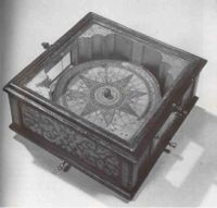
The Al-Jazari candle clock

(I have been told by several sources that it was the Islamic world that kept the Swiss mechanical watch industry alive in the 1970s and 80s.  As the quartz watch craze swept the Western world sales of quality mechanical watches dried up in the that region.  However, the demand for high end mechanical time pieces grew with Middle East customers who were flush with petro-dollars and a fascination with time.  Eventually the West came to it’s senses and the mechanical watch industry is healthier than ever.)

The human need for accurate timekeeping reached a peak in the early 18th Century with the explosion of sea-borne international trade.  By the late 17th Century we had accurately mapped the world, located the continents and key cities, and identified commercial markets. The sea-borne trade routes had been laid out, efficient ships developed and a whole maritime infrastructure established that was poised to exploit the exploding demand for international goods. The problem was that countries and corporations were losing too many ships to bad navigation. What was lacking was an accurate, easily understood and easily taught method of determining a ship’s longitude (location east or west of a prime meridian) while at sea. Fixing latitude (location north or south of the equator) was well understood and easy to determine with simple instruments, but developing a method to easily and quickly determine longitude from the deck of a rolling ship in the middle of the ocean was a problem that had vexed the best minds of Europe for hundreds of years.

By the early 1700s highly accurate land-based longitudinal determination had been going on for over 50 years, but it required complex astronomic observations and the use of large, heavy and fragile pendulum clocks. What was needed was a simple and accurate method that could be easily practiced by marginally educated ships captains across the maritime fleet. The best minds of the time understood that accurate timekeeping was the key to solving this problem, but clocks that could keep good time aboard a pitching and rolling ship were beyond the technology of the time, or so they thought. In one of the earliest examples of government sponsored applied research the British Parliament launched a competition to see who could develop an accurate method of determining longitude at sea. The ultimate winner of that prize was a self taught clock maker named William Harrison, who gave the world the H-4 chronometer and made accurate maritime navigation a reality.

It was all about time…

William Harrison’s H-4 Chronometer, 1760

(I glossed over far too many of the details related to longitude determination and the development of the chronometer, so if you want the whole story I strongly recommend you read Dava Sobel’s minor classic Longitude.)


The Industrialization of Time 


For the next 200 years the mechanical clock was refined, standardized, downsized and mass-produced to the point that the pocket or wrist watch, the mantle clock and the bedside alarm clock were affordable to the common working man. As industrialization pushed forward and workers flocked to the cities to meet the growing demand for labor, time entered our collective consciousness as never before. Suddenly a man had to be on time. On time for work, on time for lunch, on time to church, on time to the doctor. Industrialization made cheap time pieces possible while at the same time driving the requirement for better time management. One requirement fed the other.

The Big Ben mechanical alarm clock.
My Grandmother had one of these
and when it went off there was
no mistaking the message:
“Get your ass out of bed!”

The concept of parsing a day into discreet time segments for specific functions was a revolutionary concept. For most of history the worker’s day was ruled by three time checks – sun up, noon and sun down. The roosters took care of sun up, the bell in the church steeple took care of noon and his own eyes took care of sun down. That was all that really mattered. Starting in the mid-1800s, with a watch in his pocket the common man could now easily and accurately plan his day. When the boss told him to be at work at 8:00 he could backwards plan and know that if he wanted to be at work five minutes early he needed to catch the 7:30 street car, meaning he had to be out the door and on his way to the street car stop by 7:25. Likewise, if his wife told him dinner would be served at 6:00 he knew he needed to leave to saloon by 5:45 for a brisk walk home, knowing it took at least 15 minutes for the smell of beer and cheap cigars to blow out of his clothes.

But whose time was he following? You see, all time is relative. For our prototypical common man working in the mid-1800s the answer was simple – set your clock to the boss man’s clock. In fact, even today that’s a good idea (ha, ha). But what did the boss set his to? This was easy too – just set it to local time. Most clocks were regulated to local noon. The problem is that local noon is different everywhere. This wasn’t a real big deal until the railroad came to town.

For a few decades during the mid-to-late 1800s the railroads simply make use of local time. This was when railroads were a regional phenomenon with fragmented ownership. Local time was a recognized problem, but it was manageable. However, after the Civil War and the massive railroad consolidations and the push for a transcontinental rail line the major line operators realized that using local time simply was not going to work anymore. There were too many time changes as trains flew down the tracks (at a blistering 40 mph) from one town to the next or one state to the next. Since the railroads operated on a time coordination system and single rail lines were shared by multiple trains, time management became an absolutely critical issue. After a few horrific and highly publicized train crashes in the 1860s (due mainly to poor time coordination) the railroads introduced the concept of coordinated railroad (or railway) time.  It was the railroads that gave us the time zones (EST, CST, MST, etc.) we use today!

The railroads knew that for all this to work they needed to precisely synchronize time between stations. They adopted an ingenious solution that remained in use for over 100 years. Using the time signal service of the US Naval Observatory, time signals were send down the telegraph lines to allow station masters to synchronize their local station clocks. For the first time the US had a coordinated time system. For the first time someone in Denver could look at their watch and know precisely, in Denver time, when their aunt in Boston would be sitting down to dinner. It did not take long for the railroad time management standard to become the defacto national time management standard. It simply made good sense and brought order out of chaos.

The railroad industry’s demand for accurate and synchronized time spurred an interesting development in watch making – the railroad watch. Since time synchronization was absolutely essential to railroad management and safety it was imperative that all railroad line personnel (station managers, supervisors, conductors, engineers, etc.) carry time pieces that met a certain standard for accuracy and reliability. This requirement triggered the production of some of the most accurate mechanical time pieces ever developed. My Grandfather Winterberg was a maintenance supervisor on the Erie RR in Buffalo, New York during the early 1900s and carried an Illinois Bunn Special. My mother used to reminisce about watching her father wind the watch every night before going to bed and going with her mother to a jeweler in downtown Buffalo to have the watch checked and adjusted (a regular requirement imposed by the railroad). That very watch sits proudly on my mantle today, ticking away merrily almost 90 years after it left the factory.

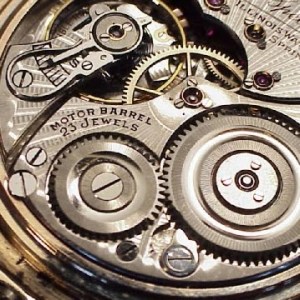
The movement of a Bunn Special railroad watch.
Not mine, but very similar.  The movements of these watches
are absolutely stunning examples of early 20th Century
industrial design and execution.

The Digitization of Time

Let’s skip forward a bit. By the late 1950s America had ‘jet age fever’; the WWII generation and very early Baby Boomers were fascinated by the promises that the new electronics industry offered. The potential of the new science of electrical miniaturization seemed limitless.  Computers that could fit under a desk, TV sets that used fewer vacuum tubes, pocket transistor radios that received AM and FM. Why, someone was even talking about using microwaves to cook food! Wow! In 1960 the Bulova watch company jumped into the market with the Accutron line of watches and they were an immediate hit. Here was the first consumer grade watch that was fully electronic. The Accutron made use of tuning fork technology to generate the time signal and it proved that fully electronic watches were not just technologically feasible but that they were accurate, practical and that there was more than enough pent up consumer demand to make them profitable.

The other impact of the Accutron and all similar designs was that consumer-grade electronic watches could now be made that met or surpassed the accuracy of high end mechanical chronometers.  For the first time ever the low level account executive wearing his Accutron to the company Christmas party could know precisely what the time was with as much confidence as the Senior VP wearing his Rolex Oyster.  Accurate and precise time keeping had been brought to the great, unwashed masses!

Workers of the world, rejoice!  You can now time the start of the Jackie Gleason Show with the same precision as your bourgeois oppressors in the executive wash room!


Let’s pause for the ‘so-what’ factor here. So the low level account executive now has a relatively inexpensive watch that offers the same accuracy as the Senior VP’s high end mechanical chronometer.  So what? Well, the ‘so what’ is really the understanding that inexpensive, high accuracy time keeping is about to be unleashed on the consumer in ways he or she could never predict. The Accutron watch was just the first manifestation of that trend.

Let’s also pause to consider just what we are talking about when discussing accuracy. There are several accuracy standards in the watch and clock making industry, but let’s use the most common and best understood: the Swiss COSC certification standard. The COSC standard for chronometer movements states that a mechanical movement can lose no more than 4 seconds per day or gain no more than 6 seconds per day over a 10 day test period. Keep these numbers in mind as we move forward.

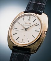
The mechanical tuning fork design of the Accutron design was good, but was ripe for improvement.  Nine years after the Accutron’s debut Seiko introduced the technology that would revolutionize the time keeping industry – the quartz watch.  The quartz watch follows the Accutron concept in that it uses an element oscillating (vibrating) at a known frequency to regulate the time signal.  In the case of the quartz watch that element is the quartz crystal.  The Japanese talent for miniaturization and integration meant that the basic quartz movement quickly found it’s way into a broad variety of watches and other time keeping and time control devices.  The physical size and power requirements of the quartz time movement went down and the accuracy improved. The Japanese electronics industry cleverly leveraged it’s lead and expertise in quartz watch movement technology into a multi-industry colossus and Japanese companies like Seiko and Casio continue to dominate the worldwide digital watch markets.

The Seiko Astron, the world’s
first quartz wristwatch

Now let’s take a look at those COSC standards I mentioned earlier.  The demand for mechanical ‘certified Swiss chronometer’ watch movements goes up year after year.  The market for high end mechanical watches is virtually insatiable.  Manufacturers like Rolex and Omega grind out watch movements by the thousands every year.  Each movement is tested by the Swiss COSC organization and those that pass receive an official Swiss chronometer certificate.  The problem is, the COSC accuracy standard in today’s terms really isn’t all that strict.  Remember, to receive a certificate a mechanical movement may not gain more than 6 seconds per day, or lose more than 4 seconds per day.  The average quartz watch from a reputable manufacturer easily beats the COSC mechanical chronometer standard.  I have a $29 Timex quartz watch that has lost roughly 1.5 seconds over the past 10 days.  That’s a 0.15 second per day loss.

[The Swiss COSC organization does have a quartz chronometer standard that is quite rigorous and any consumer-grade quartz watch would find it tough to meet the standard.  We are talking accuracies in the neighborhood of a few seconds per year vs. a few seconds per month with consumer grade watches.  Astounding accuracies by any measure, but right now we are discussing run-of-the-mill quartz movement accuracies vs. mechanical chronometers.]

Watch enthusiasts will scream that I’m ignoring a LOT that is related to quartz movement accuracy and stability, and they are right to criticize.  However, the point here is not that a cheap quartz watch can beat a high end Omega or Rolex, but that technology brings increasingly accurate time keeping to the consumer at lower and lower prices.

Today a consumer can walk into just about any watch retailer and for less than $100 purchase a quartz watch that beats a Swiss chronometer.  Now that is progress!

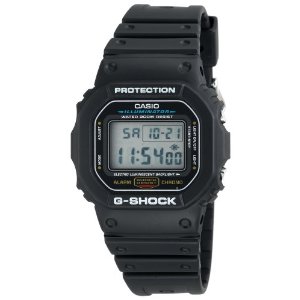
The lowly G-Shock beats the Rolex?
You bet!  In accuracy, that is.


The Sky Is (Not) The Limit


As you can tell, I think quartz watches are ‘da-bomb’; precise, rugged little time keepers that truly take a lickin’ and keep on tickin’ (props to John Cameron Swayze).  But accurate time doesn’t stop with the oscillating quartz crystal.  Time and technology march on and today the average consumer has newer, even more accurate time options.

I began this blog post with the discussion of how time and the concepts of time have fundamentally changed human culture and behavior.  Well, current and emerging technologies are poised to have an even greater impact on how time influences our lives.

Everybody knows that atomic clocks are as good as it gets for accuracy.

The first word is GPS – Global Positioning System.   (OK, three words, but who’s counting).

The second word is embedded, as in embedded (or integrated) technologies.

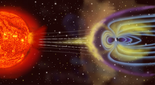
Let’s start with GPS.  Everyone knows GPS is ‘those navigation satellites’.  GPS is what your Garmin uses to fix your position.  What most people don’t understand is that the GPS system uses the concept of time shift to calculate position.  The GPS satellite broadcasts it’s position and precise time.  Your GPS unit receives that signal and calculates the time shift from when the satellite sent the signal to when it was received.  Knowing that the signal travels at the speed of light, your receiver can calculate where it is in relation to the satellite (just remember, you receiver needs the signals from three different satellites to fix your position).

To calculate an accurate time shift you need highly accurate and precise clocks at both ends – in the GPS satellites and in the receiver.  Each GPS satellite carries three or four atomic clocks accurate to about 50 nanoseconds (that’s 0.0000000050 seconds!).  But clearly we can’t stuff an atomic clock into each GPS receiver.  This is one of the neat tricks of the GPS system.  Since your GPS unit receives the time signal from the atomic clock in the satellite and it knows that signal is traveling at the speed of light and your unit is receiving the time signals from multiple satellites which allows it to average out error, with a cute bit of programming your GPS receiver is transformed into a ‘slave’ atomic clock.  This is how every single GPS receiver works.

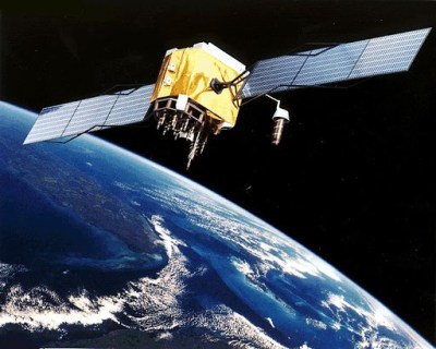
A GPS satellite.  There are always 24 in orbit providing
worldwide coverage 24/7.  Each satellite carries four atomic clocks.

Accurate time tracking and synchronization is the fundamental principle behind GPS. Every GPS receiver tracks, manages and calculates time to atomic clock accuracy and precision!

Businesses and services that used to rely on expensive atomic clocks for accurate time measurement now instead use the GPS time signal.  For example:

  • Did you know that there is a GPS receiver on top of virtually all cell phone towers in the US? No, the tower owners don’t want to track the location of their towers in case they get stolen (ha, ha), but the owners are after that highly precise and accurate time signal.  Precise time management is how cellular systems handle the transfer of a phone call from one cell tower to another. As you cruise up the interstate yakking on your cell phone your call is being automatically transfered from one cell tower to the next and the synchronization of that transfer is managed using the highly precise GPS time signal.
  • Computer networks that require highly precise time synchronization use GPS receivers as their time signal source (rather than the network time protocol servers).
  • Secure radio networks use the highly accurate and precise GPS time signal to manage ‘frequency hopping’ for all radios in the network, reducing interference and increasing security.

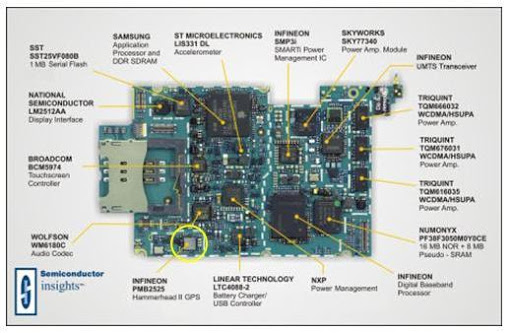
The next innovation is integration.  Manufacturers are making GPS receiver ‘chips’ that are incredibly small. How small? Check this out:

iPhone 3G main board

This is the main circuit board from an iPhone 3G.  Circled in yellow is the GPS receiver chip.  That chip is less than 4mm x 4mm!  GPS chips are now built into virtually all smartphones and are being embedded in laptop computers, PDAs, tablet computers, personal training devices and a whole host of consumer electronics that are designed for use out of doors.  Unfortunately so far this integration only takes advantage of the GPS location capabilities, not time tracking and synchronization.

This brings us to close to the end of our journey through the history of consumer time.  With the advent of board-level integration of GPS in consumer devices the market is poised to take the next leap in time measurement for the common man – atomic clock quality time in the hand or on the wrist!

However, two simple developments need to take place.

The first is the use of the GPS time signal to update the internal clocks of consumer grade GPS receivers.  All GPS receivers have an internal clock or, for board mounted chips, receive a time signal from another timing device on the circuit board.  The internal clock maintains basic system time when the receiver is powered down and, in most cases, drives the time display on the device.  As silly as it sounds, most consumer grade GPS devices do not use the GPS time signal to continuously update the internal quartz clock!  For dedicated GPS units the system may do a clock synchronization when it is turned on and first achieves GPS lock, but from there the quartz clock may drift out of sync.  For embedded systems (like the iPhone GPS chip seen above) the device only uses the GPS time signal to calculate position.  The device firmware does not allow the GPS time signal to update the system clock (a shame, because the iPhone’s internal clock is notoriously inaccurate).  While most users don’t really care about atomic clock accuracy, it is a shame to not take full advantage of that exquisite atomic clock signal coming from the satellites.

Next is the integration of GPS receivers into consumer grade wrist watches.  Manufacturers like Garmin and Suunto currently integrate GPS into their watches, but these are purpose built devices designed for specific functions like sports training or wilderness hiking.  They are not general use watches.  What watch manufacturers need to do is integrate GPS into the watch specifically for time synchronization.  Make the technology invisible to the consumer – all he or she needs or wants to know is that the watch updates itself whenever it is outdoors and it’s really, really accurate!  The technology is already there – Casio and others make extensive lines of watches that sync nightly with the time signal broadcasts in the US, Japan, Europe and China.  While this is a neat (and useful) trick, the concept is somewhat flawed  because the signals are available in only limited areas and they are easily masked or disrupted.  Since these watches already contain a radio receiver and antenna system to pick up the broadcast signals; swapping a radio receiver/antenna system for a GPS receiver/antenna system should be a fairly simple feat.  With GPS the synchronization signals are available worldwide 24/7.

Technology is on the cusp of putting atomic clock-quality time in the wristwatch of the common man.  We are almost there.  Do we need that level of accuracy or precision to guide our common daily tasks?  No, of course not.  Should we push to achieve it?  Of course!  The technology is available, proven and cheap.

So come on Casio!  Get to work on it.  I want my watch by Christmas!

_____________________________________________________

Thanks for hanging with me, dear reader!  Before I close let me clear a few things up.

First, I’m not trashing today’s mechanical watches.  From an aesthetic point of view the mechanical watch has a heart and soul that the digital watch utterly lacks.  I love mechanical watches (and own my fair share).  They are wonderful time pieces that continue to please.

Next, there are a number of ways to make quartz movements inherently stable and extremely accurate, but those methods only seem to be used on high end watches and chronometers because each unit needs to be individually calibrated and adjusted.  It is actually easier for a manufacturer like Casio to build a watch using a consumer grade (but still quite accurate) quartz movement and off-load the synchronization task to an external service like the WWV time signal out of Fort Collins, CO.  A slick and cheap trick that actually works!

And last, when I started writing this post over a day ago I wasn’t really sure where I’d go with it.  I know I wandered around a bit, but my research has taken me from the history of timekeeping to the concepts of industrial time management to the development of electronic watches to the exploding field of GPS time synchronization.  It has been an interesting and educational experience and I hope you’ve learned something along with me.

Thanks!

Brian