USGS TopoView

It’s rare that I publish blog posts back-to-back, but this new tool from the USGS is so impressive that it deserves to be showcased as soon as possible. I was chasing a link on the USGS site that was provided by a colleague in relation to my blog post yesterday on the Perrysburg Plat Map when I stumbled on a new product titled the USGS TopoView, or ‘topoView’ (note the lowercase ‘t’) depending on where you look on the site. We’ll use the more grammatically correct TopoView.

I’m not sure if this is a replacement for the USGS Historical Topographic Map Explorer released just last year or if it’s a complimentary app. The Historical Topographic Map Explorer seems more suited to map visualization on desktop systems while the TopoView app appears to be more of a data access tool, and one that is designed to run on mobile devices (although I haven’t tested it on a tablet – yet). The site runs slow so I’m guessing they have it running on a development server while they tweak the application, but when it runs well it’s a fascinating way to find, explore and even download USGS products.

I dare say, this is one web application that might just force me to go buy a plotter so I can print out my own full-scale historical map sheets.

So let’s cut to the chase. First watch this video:

Next, go play. Just click the image below to launch TopoView. And don’t blame me if your boss gripes about all the time you are spending on the computer.

USGS TopoView

Have fun!

– Brian

You Can Find Maps Anywhere!

Tonight I attended a public hearing on a Georgia Department of Transportation initiative that impacts some roads in my county. The hearing was held in a local church and as I walked out of the assembly hall I was struck by a familiar and friendly sight.

This is a wall-size map of the world produced by the old Defense Mapping Agency (DMA). The map was printed in several panels and was available for US military units to order through the local installation map warehouse or directly from DMA. The best part was, like all DMA products (maps, charts, catalogs and publications) these maps were free to the military. Order one or a hundred, it didn’t matter!

These maps adorned US military headquarters all over the world, from Korea to Germany. They hung in briefing rooms and hallways all over the Washington DC area. You couldn’t claim to have a serious operations center without at least one of these hanging on a wall somewhere.

The church apparently uses the map to track where their parishioners are from and where their missionary efforts are taking place. A wonderful use for an old war horse of a map.

It was good to see an old friend again.

– Brian

Lying With Maps

A few days ago word came out that the publisher Harper Collins and their map-focused subsidiary Collins Bartholomew released a map atlas for sale in the Middle East that completely eliminates any mention of the State of Israel.

Talk about academic, intellectual and geographic dishonesty.

Harper Collins has tried to pin the blame on market forces; seems folks in the Middle East prefer their maps of the Eastern Mediterranean to be void of any reference to the State of Israel.  Guess what? I don’t much like North Korea, and I really don’t like Alabama, but I sure don’t want them erased from my maps, at least not by some moronic map editor who is willing to toss his or her cartographic integrity into the wastebasket merely to please local prejudices.

Folks, it doesn’t matter if you like a country or not. If it has legitimate, recognized borders then it belongs on the map. The State of Israel is recognized by virtually every nation on earth and has a seat at the United Nations. Hoping it goes away by erasing its borders on a map is a silly, immature and ridiculous exercise in geopolitical wishful thinking.

The map editor that approved this map needs to surrender his/her cartographic license and leave the business of map making to those of us who have integrity and intellectual honesty.

– Brian

Topographic Instructions of the US Geological Survey

How do you make a map? More precisely, how does one produce a map compiled to specific standards for accuracy, content and style? Does that question keep you up at night? Nah, me either. But it is an interesting question and I’d bet that if you put it to 100 people you’d get 110 answers.

Of course today it’s easy. Nobody really makes a map these days. Most just go to Google Maps on their smartphone or tablet, and these days that’s about all the ‘map’ most people want or need.

But 100 years ago things were much different. Back then there were still vast unmapped areas of the US and it was the responsibility of the US Geological Survey (USGS) to send topographic parties in to map them. This was before the era of cell phones, internet, GPS and even radio communications. Checking with the home office involved the US Mail or, if they were lucky, telegraph. For that reason these parties operated autonomously under the direction of a Party Chief. The Party Chief was part military general, part football coach and part college professor; he ruled with an iron fist and made sure everything was run properly, was responsible for the motivation and morale of his party and was the brains of the outfit. The Party Chief was vested with enormous authority because he had an enormous responsibility – he answered to his regional Chief Geographer for the accuracy and quality of his party’s work.

In 1913 Party Chiefs didn’t go about their work blind. They operated under a very detailed set of instructions and standards laid out in a USGS publication titled Topographic Instructions of the United States Geological Survey.

Topographic Instructions of the USGS

I find this a fascinating manual because it is the only publication I’ve seen that lays out in detail the steps necessary to create a map from scratch. It covers all the processes involved in creating a map to very specific accuracy, content and composition standards. This is, quite literally, the document that defined what we know today as the standard USGS topo quad sheet. Of course the USGS was producing standard topo sheets before this manual was published, but indications are that prior to 1912 the instructions were covered in separate publications and broken out by discipline. This manual brought it all together in a single reference that is remarkably clear and concise for its time, stripped of a lot of the superfluous language that Edwardian-era government functionaries were so fond of using. This is a manual designed to be used in the field by men who have a job to do.

The topics covered include

  • primary and secondary triangulation
  • primary and precise leveling
  • plane table surveying
  • map construction (compilation), drafting and editing
  • instrument care and repair

But beyond the technical, Topographic Instructions of the United States Geological Survey covers detailed administrative instructions to Party Chiefs on topics like crew selection, first aid for pack animals and crew members, how much food to pack, how many fountain pens to bring along, how to set up a base camp, even how to interact with local officials and the press.

It’s a soup-to-nuts manual on how to make a map from scratch.

– Brian

Mapping the Assault!

OK now, everybody hum a few bars of the Barry Sadler song, Ballad of The Green Berets.

It’s the mid-1960s. The Vietnam war is still a ‘good’ war in the minds of most Americans. In 1961 President Kennedy had turned the spotlight on the US Army Special Forces, the Green Berets. When Kennedy found them they were an obscure group of soldiers operating out of Fort Bragg, North Carolina, led by officers who had worked closely with partisan groups during WWII and understood the value of conducting behind-the-lines operations to disrupt, demoralize and undermine an invading enemy’s operations. The Big Army brass didn’t much like them – they were independent, unorthodox, and perhaps worst of all they insisted on wearing those damned green berets. But they were having an impact, particularly in Southeast Asia where they were leading South Vietnamese and other native forces in surprisingly effective operations against the Viet Cong and other communist-inspired forces. The Big Army brass may not have liked these cocky Green Berets but there was no arguing they were having great success with their unorthodox methods and tactics.

Then in 1965 author Robin Moore published his best seller ‘The Green Berets‘, a semi-documentary novel of Special Forces operations in Vietnam. Moore had spent almost two years training and then deploying to Vietnam with a Special Forces unit so he was writing from the inside, with a special perspective on the unit, its men and its mission. (Significantly, Robin Moore is the first and, as far as I know, only civilian to attend and graduate from the US Army Airborne School at Fort Benning and earn his jump wings.) Moore’s book was an instant best seller. It pushed the Green Berets back into the spotlight and, this time, into popular culture. Suddenly America couldn’t get enough of the Green Berets. There were Green Beret magazine covers, comic books, toys, documentaries, songs and a John Wayne movie. And even trading cards. Yes, bubble gum trading cards!

Mapping the Assault In 1966 the Philadelphia Chewing Gum Corporation (P.C.G.C.) got the rights to use some US Army promotional photos on a series of trading cards about the Green Berets. There were 66 cards in the series (one card to a pack of gum to ensure brand loyalty and continued sales). The cards were typical Army stock photo stuff – Green Berets jumping out of airplanes, rappelling out of helicopters, training with machine guns, etc. All highly sanitized for mid-60’s pre-teen consumption. No blood, no gore, no torture (you know, the typical stuff a pre-teen sees today on prime-time television). I’m not sure how long the series ran, but I do remember seeing these cards for sale and buying a few myself while my family lived in New Jersey back in the 1960s.

Since this card is the only one of the set that deals with the use of maps I thought I’d toss it up here. It looks like the picture was taken during an exercise. The white tape pinned around the sleeves of some of the Special Forces soldiers indicates they are evaluators (‘white force’) for an exercise, and may be providing an overall exercise briefing to the two Green Beret soldiers standing on the right and staring intently at the map board. It must be raining outside, because these two visitors are wearing their wet weather jackets and they look damp.

The picture quality isn’t good enough to indicate what area the maps on the map board cover, but it’s a good bet that it’s somewhere around the Fort Bragg area. You can make out some geographic boundaries highlighted on the map board, and one has been named ‘Maple’ (or ‘Marie’) and the other ‘Woody’. Probably notional countries or regions created for use during the exercise. Based on the general patterns I see on the map board these are probably a series of Army Map Service 1:50,000 scale map sheets taped together to make one large, continuous coverage map.

There’s little else we can glean from the photo other than it’s cold (and wet) outside – many of the participants are wearing what look to be M-1951 field jackets. The overall setup has a familiar exercise control cell look about it, somewhat spartan with the field table and chair set before the map, a copy of the exercise order sitting on the table and some status boards and another map board hanging on the wall to the right. Been there, done that many, many times over.

I’m told by active duty soldiers that things haven’t really changed. Even in this era of unlimited bandwidth, live data feeds. advanced digital mapping and command and control software and high resolution large format displays there are still old-fashioned map boards that go up for every exercise ‘just in case’.

I guess the more things change the more they remain the same. Makes an old topographer smile.

– Brian

Hey Kids, Let’s Order A Map!

The mailman dropped off something nostalgic a few days ago, an Army publication from the days when men were men, HMMWVs were new and the Army still ran IBM 360 mainframes.

That would be back around the end of the last ice age, or 1984 to be exact.

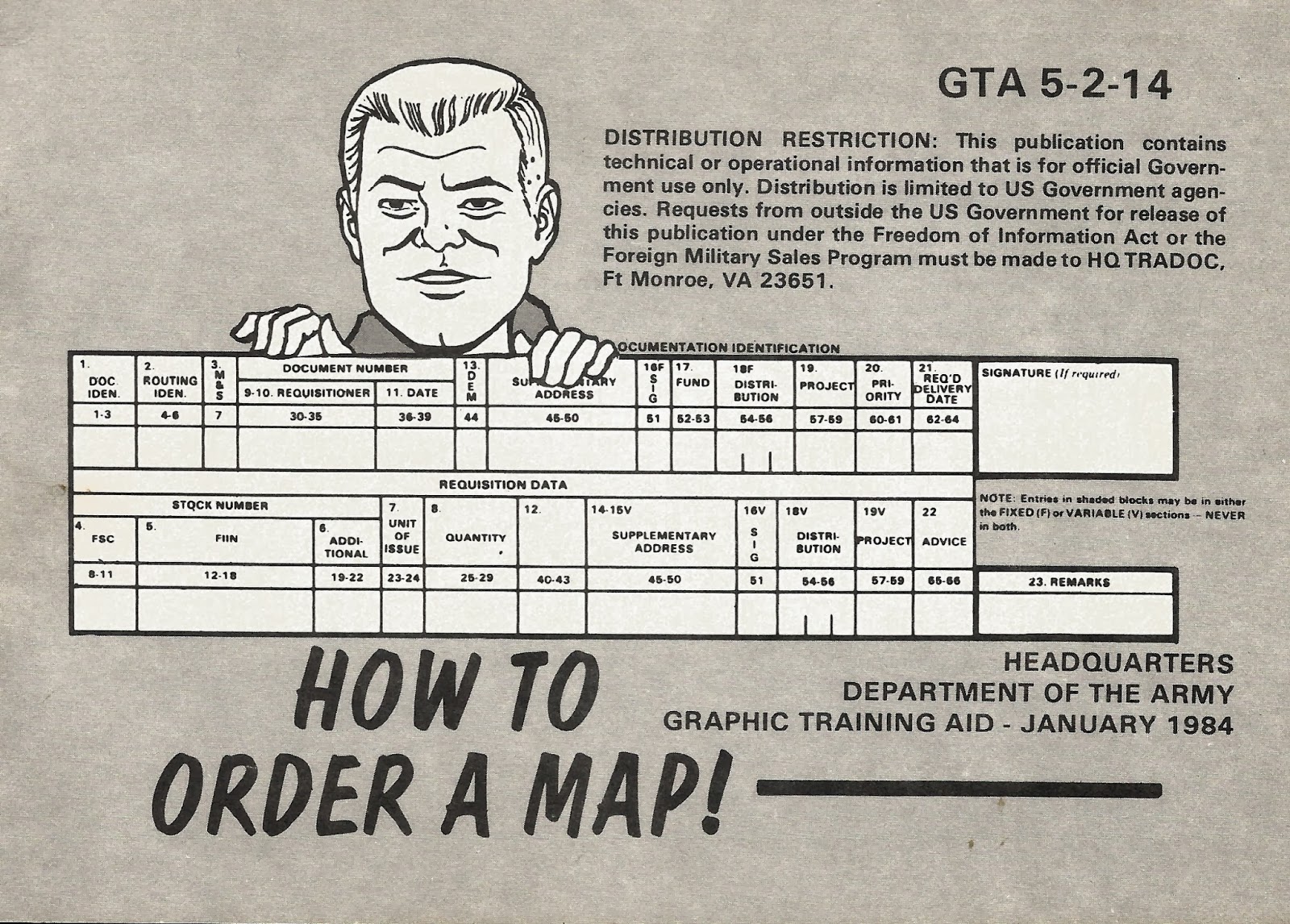
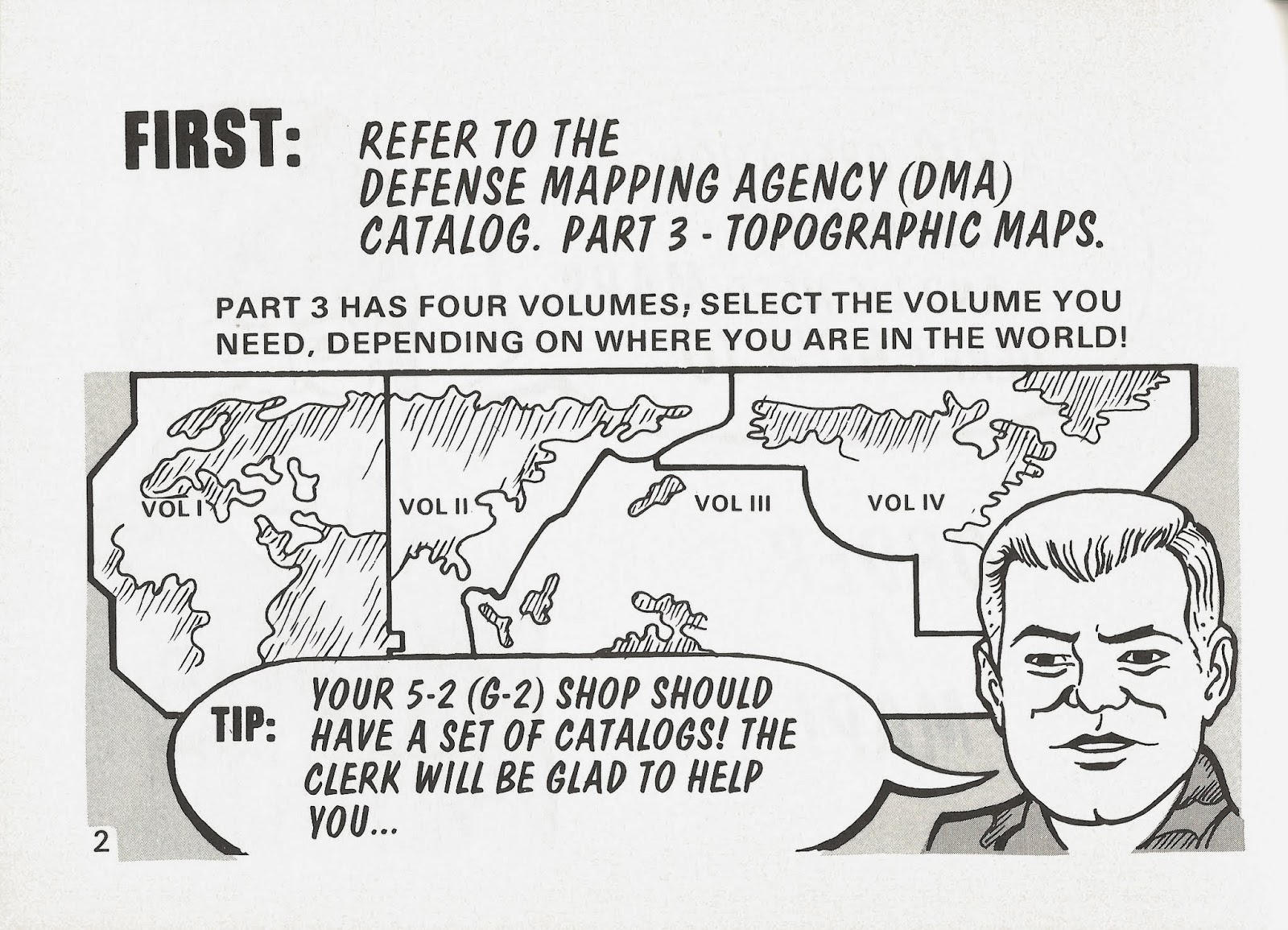
Need a map?  The Army Engineers came up with this nifty graphic training aid to guide you through the arcane process of ordering maps.

Now, map supply was no minor concern.  The Army had an almost insatiable appetite for paper maps, and in 1984 that demand was filled by the Defense Mapping Agency (DMA). The Defense Mapping Agency was a victim of its own success. They did such a good job of compiling, printing, distributing and updating their standard map products (which covered literally all of the world at one scale or another with the exception of the US and its territories – that job fell to the USGS), and they didn’t charge for their services. You could order all the maps you wanted and have them delivered for free.  Even better, if you set up an automatic distribution account the Defense Mapping Agency would automatically ship you any updated map sheets for your area of interest whenever they were published.

As a result maps became a commodity item, something everyone was used to having immediately available at any hour, day or night.

In reality, we had to order the darned things, and the ordering process could be pretty tricky.  Like many things in that great machine known as the Army supply system, if you filled all the paperwork out right you stood a 50/50 chance of getting what you ordered.  If you made even a slight mistake – say you accidentally put down an incorrect map sheet number – your requisition was routed straight to supply system purgatory, where it languished indefinitely while your installation logistics office returned the dreaded ‘BB’ (backordered) status month after month after month.

So let’s peel open GTA 5-2-14 and see what it has to say about ordering maps.


Yes sir, let’s put that funny shaped helmet that’s two sizes too small on our head and get to work.  Question – did the Army pubs system only hire third graders to do the illustrations for their training aids?  Anyway, we’ve got a big operation coming up.  The weather’s warming up and the Command Sergeant Major wants a briefing on the post spring cleanup plan. That’s as big and hazardous an operation as any I’ve ever encountered!

So the 5-2 has the map catalogs?  Oh sorry, that would be the S-2.  Didn’t anyone at the Engineer School take a look at this thing before giving the go-ahead to print and distribute hundreds of thousands of copies? Anyway, as a former battalion S-2 I can confirm that I had a complete set of DMA catalogs.  I kept them locked in the bottom drawer of my safe, along with a loaded pistol, in case a second lieutenant dropped by to try to teach him/herself the arcane art of ordering maps.  DMA map catalogs were simply too dangerous to leave unsecured.  Someone might do something dumb and I’d come to work one day to find pallets of maps sitting outside my office (remember, they’re free and DMA will ship as many and as often as you like).

Oh damn.  It’s about to get tricky…

The DMA map catalogs were hundreds and hundreds of pages of small scale maps covered in teeny-tiny squares, each with a unique number.  Each square represented an individual map, and you were expected to put on your reading glasses (or for the really cool intel types, pull the monocular magnifier out of the Photo Interpretation Kit) and start writing down the number for each and every map you need to order. Remember, no mistakes!

Got it?  It’s at about this point that the average second lieutenant’s eyes would glaze over…

This is where those in the know could have some fun.  See that Priority box?  If you wrote ‘3’ in there you’d get your maps pretty quick, but if you put a ‘1’ in there you’d start alarm bells ringing all around the Washington D.C.beltway as flag officers tried to figure out just why the 443rd Mess Kit Repair Battalion at FT Bragg needs 500 copies of every map of Western Europe by noon tomorrow.  What do they know that Washington doesn’t?  Maybe the 443rd is just a cover unit for Delta Force?  Yeah, that has to be it!

Flat or folded?  That’s like ‘boxers or briefs’.  It didn’t matter what you put in that box, you were getting folded maps.  Ever tried running a folded map through a Heidelberg offset press to print an operations overlay?  It didn’t work.  We tried everything short of holding the DMA director hostage at an undisclosed location in a strip club on 14th Street in Washington D.C. to get them to ship unfolded maps, to no avail.  I think DMA just did it out of spite.  Oh, and don’t forget to have an officer sign the requisition, because everybody knows only officers know what’s going on.  You gotta’ wonder how many requisitions were submitted with signatures that read “Mickey Mouse, 2LT, IN”.
Where indeed to send that requisition?  We’ll have a look at what the GTA says, then I’ll reveal the real secret to map supply!
Going to war in Europe?  Send your request to the 649th at Tompkins Barracks in Schwetzingen.  Judging by where the artist placed the star, Schwetzingen is located somewhere near the Polish/Czech border.

Going to war in Korea?  Send the request to the USFK Engineer office.  Going surfing Going to war in Hawaii?  Send your request to Hickam Field.

Planning to go to war in Central or South America?  Send your request to the DMA distribution office in Panama.  I actually have a soft spot in my heart for this office.  While stationed in Panama as part of the US Army South DCSINT I used their services a lot.  The map warehouse was run by the Air Force and those guys were great.  I’d call them from my office, tell them what I needed, hop in my HMMWV and drive up the road to Albrook Air Force Station and they’d have the maps sitting on the counter waiting for me.
Well kids, we’ve come to the end of our class on ordering maps the Army way.  This GTA makes it look easy, right?  We’ll listen close and I’ll tell you how map requisition really worked at places like FT Bragg, FT Campbell, FT Hood and other major installations…  you’d just drive over to the installation map warehouse and start banging your fist on the counter until the map distribution guys coughed up what you wanted.  It also helped if they were in your company and they worked for you.  I don’t think I used these ordering procedures more than once or twice in my whole career.
– Brian


Gas Station Maps

In olden times, like back in the 1960s, you could pull into any gas station in the US and grab a free road map.  These maps were designed for one purpose – to show the motorist how to get from where he was to where he wanted to be.  The maps were part advertising and part incentive.  The idea was to encourage travel by automobile.  The more you traveled the more gas you burned.

The idea of the free road map was born back in the early 1900s when automobile companies like Ford were involved in a major push to get the state and federal governments to expand and improve roads throughout the country.  Road conditions were simply awful back then and the thought was that better roads would encourage travel and commerce and, of course, spur automobile sales.  This led to the creation of the federal Bureau of Public Roads (later the Federal Highway Administration) and the first allocations of federal money for ongoing road construction and maintenance.

By illustration, one of Harry Truman’s standard campaign platforms when he was serving as a commissioner in Missouri, then Senator and ultimately as President was better roads.  He felt that no farmer in a rural area should have to travel more than two miles to find a paved road to get his crops to market.  The fact that two miles was viewed as a reasonable distance to have to haul products before finding a good road is reflective of the state of road construction in the rural areas of the country right up into the 1950s.

Well, if we’ve got all these good new roads how do we let people know about them?  Why the road map, of course!  Gasoline companies like Texaco, Shell, BP, Mobile, Standard Oil and many others viewed free road maps as part of the cost of doing business.  The gasoline companies didn’t do the map production themselves.  They farmed out the production to one of the few companies that specialized in making road maps.  Rand McNally, Gousha and General Drafting were the major players in this industry and they cranked out millions of maps between 1920 and 1970.

The other great thing about gas station road maps, besides being free, was that they were kept fairly current.  The compilation of these maps was a cooperative effort between the gasoline producers, the mapping companies and local, state and federal road and transportation bureaus.  Maps were updated and re-published as frequently as every year depending on the rate of road construction in a particular state.  Of course each gas company’s map was tailored to show company service stations and to proudly trumpet the superiority of their product over their competitor’s, but the actual map information tended to pretty consistent from company to company.

A side benefit from this program was the standardization of road map symbology.  Map makers realized we needed a common map language to depict things like primary roads, secondary roads, city boundaries, rivers and lakes and route symbols.  In very short order common symbols were standardized and used on all road maps, not just those handed out for free in gas stations.  Map symbols were a unifying language on the highways and byways of mid-20th century America.

In addition, millions of American school kids learned map reading from gas station road maps.   Schools regularly integrated map reading into the curriculum, and the map of choice was the good old gas station road map.  I think the peak of America’s map literacy came in the 1950s, when millions of American kids, eager to tell their parents where to go, took over the job of automobile navigation and honed their skills in route finding and trip planning with good old gas station maps.

In the 1950s we planned our journeys using a paper map and imagination.  Today we fire up the GPS and wait for it to tell us where to go.  I fear we have become map dummies.

Let’s take a trip back in time and see what it was like for a mapping company to keep up with changes to roads and road conditions.  Many would be surprised to learn that the methods used today are pretty much the same as we see in this video.  The equipment has changed – it’s all computerized now – but someone still has to drive the roads and note the changes.

– Brian