Ted Abrams

Yesterday the December issue of American Surveyor magazine appeared in my mailbox. American Surveyor is one of the few trade publications I read from cover-to-cover every month, and it’s one of the very few I’d gladly pay a subscription fee for. But since the publisher, Cheves Media, provides it free of charge all the better.

American Surveyor DecCover2015full

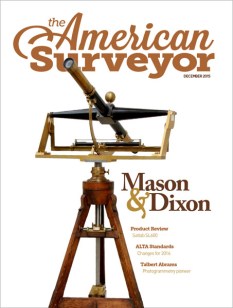
This month’s issue hits it out of the ballpark. The cover is one heck of a teaser – a beautiful shot of the John Bird transit telescope used by surveyors Charles Mason and Jeremiah Dixon to establish the boundary between Pennsylvania and Maryland just before the Revolutionary War. This is the famous ‘Mason – Dixon line’ that today is viewed (incorrectly) as the cultural and political dividing line between the American North and South. Mason & Dixon’s achievement is an important topic in the history of topography in the Americas and we’ll have more on it in a later post.

Today however we’ll focus on the other key article in the magazine – a short overview of the achievements of Ted (Talbert) Abrams, an early pioneer in the science of photomapping and and photogrammetry. Abrams was one of the quiet heroes of topographic history, someone most have never heard about but who’s accomplishments revolutionized science, established an industry and helped found the geospatial profession many of us practice in today.

Ted Abrams

Just what were Ted Abrams’ achievements? He effectively invented the business of photomapping. It was his experience as a US Marine Corps reconnaissance pilot during WWI that convinced him that aerial photography could be used to make highly accurate maps. At the time traditional mapping technology required the use of ground survey and field verification crews to literally walk and survey the areas to be mapped, usually using laborious plane table survey methods. The process was slow and expensive. One of the earliest uses of aircraft during WWI was to take vertical photos of battlefields for the creation of map substitutes. These were simple photo mosaics annotated with things like road and town names, but they filled a critical need.

Coming out of the war Abrams was convinced that photomapping could not just be a viable business, but could revolutionize the science of large scale mapping over broad areas. Ted Abrams was part pilot, part scientist and part entrepreneur, and all genius. Where no industry existed, he developed the techniques and the instruments necessary to capture and process tightly controlled areal mapping photography and compile accurate maps from that data. He then developed the business model that made it all profitable. He also helped develop a lot of the science behind the processes involved in photomapping. You can’t claim your maps and photo mosaics are accurate unless you can prove the mathematics and geometry that went in to making them, and Abrams was an early pioneer in developing the mathematical principles behind processes like aerotriangulation.


Ted Abrams was also a life-long patriot and a proud Leatherneck. During WWII he set up schools that trained thousands of Marine Corps photo mapping and photo analysis specialists, and his techniques and textbooks were in wide use across all the military services. One of his simplest yet greatest accomplishments was the invention of  the folding pocket stereoscope. This stereoscope was manufactured by the hundreds of thousands by the Abrams Instrument Corporation and other manufacturers and became the indispensable tool of photo interpreters, surveyors, cartographers and intelligence analysts around the world.

Frost Course Module 3 blow-up

Invented by Ted Abrams in 1942, the simple folding pocket stereoscope has been the indispensable tool of topographers for over 70 years. They are still in wide use today

After the war Abrams’ business flourished as America went on a building boom. He built Abrams Aerial Survey into the leading aerial survey firm in the United States and the Abrams Instrument Corporation became a leading supplier of aerial photography, photogrammetry and aerial photo analysis instruments.

Ted Abrams was a founding member of the American Society of Photogrammetry (now the American Society of Photogrammetry and Remote Sensing (ASPRS)) and much of his pioneering work made its way into the first editions of the industry’s standard reference, the Manual of Photogrammetry.

Manual of Photogrammetry

In recognition of Abrams’ contributions the ASPRS presents the Talbert Abrams Award every year to ‘encourage the authorship and recording of current, historical, engineering, and scientific developments in photogrammetry.’

One last example of Ted Abrams’ genius. He came out of WWI with a clear understanding of the limitations of current aircraft designs when used as platforms for aerial cameras. Abrams knew he needed a more stable aerial survey platform designed around the needs of the camera system and crew. In the 1930’s Abrams sat down and designed what became the world’s first dedicated aerial imagery platform – the Abrams P-1 Explorer.

Abrams_P-1_Explorer

First flown in 1938, it was specifically designed for the mission of acquiring aerial mapping photography. The P-1 incorporated a number of unique design elements, including a pusher-type engine arrangement designed to keep leaking oil and fluids from smearing the camera lenses (a serious problem with conventionally laid out aircraft using rotary engines), and it was one of the earliest aircraft to utilize Plexiglas for windows. In fact the nose layout made its way into WWII military aircraft designs, particularly the nose arrangement of the early B-24 Liberators.

Unfortunately the P-1 design was a victim of war. By the time the aircraft became operational proved itself as an outstanding aerial camera platform WWII had broken out. The US Army Air Corps looked at the design and deemed it too slow and too vulnerable to enemy fire. Ted Abrams realized he needed to work on ways to mount mapping camera systems in fast moving fighters and modified bomber aircraft and threw himself into the task without looking back. Only one model of the P-1 was ever built and it remained in operation in the US until 1948.


A fascinating aircraft designed by a true genius and pioneer in our industry. We truly do stand on the shoulders of giants.

Brian

US National Grid – An Update

It’s been a while since we’ve discussed the US National Grid, but I was recently brought back to the topic.

Last week at work I got involved in a debate with some of our emergency response managers and operators on the issue of map grids. We are putting together a comprehensive emergency operations dashboard (web map) and I thought it would be useful to have a standard grid available that all agencies can use, understand and reference their response efforts against.

My first reaction was to just go ahead and use the US National Grid (USNG). It is easy for us to create web and paper maps that display the grid, it is easy to understand and its use is mandated by federal policy (or so I thought). I was quickly shot down. Someone in the ops group produced a PDF of a map displaying an arbitrary alphanumeric grid. This grid was generated a half decade ago by someone who is long gone and nobody knows where the CAD file is that holds the original grid drawing. Yet this grid has been ‘approved’ by a large federal agency with wide ranging authority and so it was deemed the grid for emergency responders to use. It didn’t seem to bother too many folks that the only place the grid existed was on this small scale PDF. No way to update the underlying map or photo, no way to bring this map into other products. It didn’t matter – this was the approved grid, period.

What really got my attention was when one of our emergency services coordinators, a good guy who’s had (by his estimate) hundreds of hours of federally mandated (and developed) training on disaster response, told me that in all his training classes he’d never even heard of the USNG.

Your tax dollars at work.

In the end we gave up and one of our sharp geospatial analysts was able to recreate the grid as a georeferenced polygon layer using the Data Driven Pages functionality in ArcGIS. So now this approved grid exists not as an overlay on a static paper product, but as a scalable data layer that can be easily incorporated into paper or web based map.

But still, USNG soldiers on. I snuck it in as a data layer in this operations dashboard. It’s turned off by default, but it’s there if needed. I guess everybody’s happy. The ops guys get their arbitrary grid that has no real relation to any recognized spatial coordinate system, but hell, it’s approved! I get a grid that may (or may not) be approved and mandated by the Feds, that every emergency responder gets schooled on when he/she goes for federally mandated training (or maybe not), and is supposed to be the standard emergency response grid system in use by the federal government (perhaps).

Again, your tax dollars at work.

In working through this issue and trying to find documentation and guidance on the mandated uses of USNG I happened on this interesting site, the US National Grid Information Center:

USNG Information Center

This site holds a lot of great information on the USNG and its applications, and I encourage everyone who deals with USNG or MGRS to spend some time going through the resources.

Even more interesting, it appears the site is not maintained or supported by any federal agency or the FGDC (the ‘father’ of the USNG concept). This is all a private effort and the site is supported by the SharedGeo organization.

So here’s an example of your tax dollars not at work, and it’s a good thing!

Brian

I’m Always Going Somewhere

Time for a book review. In fact, this review is long overdue. I’ve mentioned before in this blog that the history of the Inter-American Geodetic Survey (IAGS) is poorly documented. As far as I know its parent agency, the US Army Corps of Engineers, has never published a comprehensive general history of the organization and its achievements. But then, the modern Corps of Engineers has never been particularly interested in celebrating its topographic history and lineage (yes, that’s a dig).

Earlier this year I was contacted by an IAGS alum, Paul Hauser, who was putting together a book on his personal experiences while working as a geodesist for the IAGS from 1968 to 1970. He was incorporating experiences from other IAGS alumni and contacted me for permission to use some of the material I’ve posted on this blog and website.

A few months ago Paul’s book was published and he graciously provided me a copy to read and review. The book, titled I’m Always Going Somewhere, is less a history of the IAGS than a collection of personal experiences that detail what it was like to work as part of the field parties that the IAGS deployed all across Central and South America. But in these stories you get a real sense of how the IAGS accomplished its mapping and surveying missions in some of the most remote (and dangerous) areas of the world and in an era before GPS, high resolution satellite imagery, smartphones, tablets, laptop computers and GIS software.

I'm Always Going Somewhere

Paul and his contributors Roald Bendixen and Carol Ann Skillern have put together a remarkable and important collection of their personal experiences while working in the IAGS. If you have any interest in the IAGS or the history of mapping and surveying I strongly encourage you to get a copy of this book.

My hope is that this book will encourage other IAGS alumni and the family members of alumni to come forward with their stories so we can start to build a more complete history of this fine agency.

I’m Always Going Somewhere is available from Amazon in both print and Kindle editions

Brian

The Brunton Cadet

This website has covered the Brunton pocket transit and its clones in-depth, but there’s one design that shares some of the classic pocket transit DNA that we haven’t looked at yet – the Brunton Cadet pocket transit.

Brunton Cadet

I’m not sure when the Cadet was introduced, but I’m guessing they hit the market in the late 1950’s or early 1960’s. The next question is, why? The cadet offers about 50% of the functionality of the classic pocket transit design (it lacks a needle dampening system, leveling bubbles, extended sighting vanes and an adjustable clinometer) and comes in at less than 1/4 the price of a base model Brunton pocket transit. My guess is that Ainsworth (the original manufacturer of both the Brunton pocket transit and the Cadet) was getting a lot of requests for a compass that had most of the features earth science students needed to get the job done, but at a much lower cost as compared to the classic pocket transit.

To answer the demand Ainsworth produced an all-plastic compass that is the same basic size and shape of the classic pocket transit but is greatly simplified. My example was produced sometime in the 1960’s, judging by the marking on the box. It offers a sighting mirror, clinometer and a compass ring set off in both degrees and quadrants (a neat idea that could have been migrated over to the standard pocket transit but, alas, never made it there). On my example the sighting mirror is a heavy piece of mirrored glass with a sighting line scored down the center and (I’m assuming) glued to the compass lid. The undampened needle has no obvious north markings on it save for a small hole punched in the needle to indicate the north end. The clinometer is a simple free swinging indicator affair set off in degrees of slope, but not percent.

Ainsworth claimed this is a ‘training’ compass, intended to teach students how to use the full featured pocket transit. Printing on the side of the box even states that the Cadet affords “… all the applications of the Brunton Pocket Transit, Basic Mapping Procedures, Plotting, Dip & Strike, Clinometer, Alidade, Prismatic Compass”Boy that’s a load of bull! Without bubble levels it is impossible to do accurate strike and dip measurements on rock formations, so the Cadet’s usefulness for geology field work is limited. Without the sighting vanes it is impossible to use it as an alidade. With an undampened needle it’s extremely difficult to use it as a plotting tool or to accurately set a bearing. And it’s not a prismatic compass, it’s a mirror compass. Clearly the advertising guys at Ainsworth never took these things to the field before writing the copy. What the Cadet does remind me of is an old forester’s compass, but with a few added features. Perhaps it was designed to steal market share from the Silva Ranger compass, which was gaining in popularity in the US in the post-war period among foresters and others who needed to do rough field work with a map and compass.

Brunton Comparison 2Ainsworth Brunton pocket transit and the Ainsworth Cadet. Both were manufactured around the same time period

But the Cadet design (or price) must have resonated with many college and university earth science departments because I remember seeing them in the pile of pocket transits available in the geology department when I was attending school. I never used one – as a poor geology student I relied on my Silva Ranger for map and compass work and if I needed to do strike and dip measurements I just borrowed someone’s pocket transit.

Brunton Cadet Manual Front

Brunton Cadet owners manual (click to open)

Which leads, I guess, to the point of this post. The Brunton Cadet is interesting if you like to study the lineage of pocket transits, but it really doesn’t work all that well in today’s world. If you need a pocket transit just suck it up and buy a full featured model. The Cadet is still produced by Brunton and right now is sells for a little over $40 on Amazon. It’s a big step up in price to the cheapest full featured pocket transit, the Brunton ComPro (at just under $250 on Amazon), but the ComPro is a professional instrument and well worth the investment. If you just need a sighting compass there’s any number of mirrored sighting compasses available close to the Cadet’s price point that do a much better job. My personal recommendation is the Suunto MC-2.

We’ll just call the Cadet an evolutionary dead end on the pocket transit tree of genetic diversity. An interesting item for study, but one pushed out of the ecosystem by more evolved competitors.

Brian

The National Geographic Society Is In Trouble

Reports came out this week that the National Geographic Society (NGS) is in serious financial trouble and has sold controlling percentages of its magazine and film production business units to the Murdoch enterprise.

NatGeo

Yes the NGS is in trouble, but not because Rupert Murdoch now has majority ownership of the Society’s flagship magazine. No, the NGS is in trouble (and has been for years) because its directors and editors have allowed a once world class general interest science, geography and exploration magazine to devolve into just another ‘me too’ hack global warming/ivory poaching/rain forest shrinking/sea level rising/save the whales rag.

I used to be an avid reader of the NGS magazine. This is the scientific society that probed all corners of the world, went to the North Pole with Peary, to the depths of the oceans with Cousteau, to the top of Everest with Whittaker, to the Olduvai Gorge with Leakey, to the Gombe with Goodall, supplied presidents and generals with maps of battlefields when no others existed, educated a homefront on what world war really meant, and helped generations of budding young explorers, adventurers and dreamers (like me) visualize a world far beyond the limits of their small towns and villages.

My wife and I subscribed to the monthly magazine for over two decades and they usually got read cover-to-cover. Our kids eagerly devoured the children’s magazines and hardback books. The Society’s TV specials were infrequent but always produced to the highest standards and well worth letting the kids stay up and watch. And their maps – oh, their maps! Some of the most glorious examples of cartography ever put to paper. We collected and carefully cataloged all the magazines, and I began a serious search to fill out the collection with pre-1950 editions. Somewhere along the way it dawned on me that the modern magazine editions (mostly post-1990) are just not worth keeping around. They simply lacked the substance that was found in the earlier editions. So out the door they went to the rummage sale. Today the only editions I keep are those from WWII and earlier.

It seems the NGS tried to put revenue ahead of quality. They decided that a superficial pass at every environmental issue du jour would sell more magazines than serious inquiry and quality coverage. Political correctness replaced intellectual rigor and inquisitiveness. When every other magazine on the rack is covering and saying the same things it’s hard to stand out from the competition, particularly when the competition also provides updates on the latest Kardashian wardrobe problem. Starting a decade ago I noted that the quality of the Society’s coverage of scientific issues was about the same as you’d find in The Atlantic, or Salon, or Mother Jones. In the end the plan didn’t work. Rather than separate itself from the herd and offer unique investigations into interesting and important topics the NGS stuck with a losing formula. It now finds itself selling off the magazine – the  jewel in the crown started by luminaries including Alexander Graham Bell and Gilbert Grosvener – to an Australian newspaper magnate. How sad.

Perhaps this financial crisis will be a wake-up call to the Society’s directors and editors. Lets hope so. The National Geographic Society is a national treasure, but she’s like a tired old statue of a heroic figure you’d find in a public park, in need of a good cleaning and a new foundation to stand on before it can shine and inspire for the next 100 years.

Brian

The Old Topographer’s Web Map Gallery

I decided it was time to open my personal ArcGIS Online web map gallery to public scrutiny. This ArcGIS Online site an extension of my Old Topographer/Northing & Easting web environment.

I do a lot of tinkering with web maps using ESRI’s web mapping technology and occasionally I come up with something I think may be useful or interesting to the general public. When I do, those web maps will make their way to this gallery for everybody to try out and comment on.

I also added the gallery as a permanent link (Web Map Gallery) on the links bar at the top of my blog header.

So go have a look, play around, and let me know what  you think! (Just click on the image below)

Old Topographer Website

– Brian

The Vanished Town of Glastenbury and The Bennington Triangle

Let’s showcase someone else’s work for a change. Chad spins a wonderful yarn about New England history as depicted in the life, and death of the small villages and settlements that used to cling tenuously to the wooded slopes of Vermont. Cartography and the sense of place help tie everything together, and this is as much a story of the land as it is the story of it’s inhabitants. Enjoy

Obscure Vermont

Those who know me know that I’m a huge cartography buff. That love really perpetuated when I was 10, when my mother bought me a DeLorme atlas of Vermont, and I became enthralled with it, thoroughly memorizing every detail I could. But what is it about maps that are so irresistible to me?

Maybe because of their limitless potential, and their ability to unlock the mysteries of our world. Maps tell us how things in this world relate to one another, they take data and turn it into something tangible, something understandable, and maybe something that provokes thought or feelings. Several different types of information can be conveyed at the same time, melding several different ideas into a united idea. Lines to convey topography, more lines to convey boundaries between rock layers, towns, states and countries. More lines for faults, colors for bodies of water, forest land and types of climates. Maybe it’s…

View original post 6,510 more words

An Android Rant

I’m a big Android fan and have been for about two years.

android bot

For almost eight years I’ve used Apple’s iOS mobile devices at work and at home. I understand and respect the high level of software and hardware integration that Apple brings to its ‘ecosystem’. It makes managing and troubleshooting the devices dead simple, particularly if, like me, you serve as tech support for a large pool of family and friends, many of whom live hundreds of miles away.

A number of years ago, on a whim, I picked up a Samsung Galaxy Player 5. This now defunct product was Samsung’s answer to the iPod Touch. It was (and still is) a great idea – a phone-sized tablet that offered everything except the phone. It ran an early version of Android 2.x (Gingerbread). I found the hardware compelling but the Android operating system somewhat limited, particularly when contrasted against the then current version of iOS.  I concluded at the time that the Apple devices were just the better option and I pushed my family and my employer towards iPhones and iPads.

samsung-galaxy-player-5.0

Samsung Galaxy Player. Good idea. Good hardware. Too bad the OS wasn’t quite ready for prime time

I always kept track of what was happening in the Android market and at the same time I personally adopted Google’s cloud services for data storage and desktop apps like Google Docs. I became increasingly impressed with Google’s moves to provide a seamless user experience across a variety of devices, from desktop to tablet to phone. At the same time my frustration with iOS started to build, particularly with those devices we used at work. In an enterprise environment with an overbearing IT department the need to manage each device via individual iTunes accounts became a real PITA (that would be, pain-in-the-a**). It got real old real fast trying to educate new iPhone and iPad users on the very clumsy iTunes interface. It also got tiresome justifying time and again to our IT department why we had to spend an extra $100 per iPad just to get GPS capability. But we pressed on because at the time the apps we wanted to run – ESRI’s ArcGIS and Collector apps – either weren’t available for Android or ran much better on iOS devices.

A few years ago a co-worker brought in a Google Nexus 5 phone running Android 4.1 (Jellybean) and he let me play with it for a few hours. I quickly realized that Jellybean ain’t Gingerbread. I knew it was time to give Android another look. Soon after I picked up a Google Nexus 7 tablet and immediately got hooked on both the device and Android 4.x. Within 3 months I gave my iPad to my daughter and never looked back. Since this is a discussion about operating systems the only thing I’ll say about the Nexus 7 is that it is the best tablet I have ever used, period. I’m still upset that Google killed it off in favor of a larger form factor tablet and I’ll nurse my Nexus 7 along until the the last electron leaks from the battery and it can no longer take a charge. But as I found with the Samsung Player, good hardware isn’t worth much if the operating system is lousy. What pulled me towards the Nexus 7 was the much improved quality of the Jellybean operating system. While the earlier Gingerbread OS seemed to be one step removed from a hacker’s toy, Jellybean (despite the silly name) was a mature, well integrated OS. Even better, the GIS apps I wanted to run – ESRI’s ArcGIS and Collector – were now available in mature, stable versions for Android.

The Google Nexus 7 (2013 version), perhaps the best small tablet ever made. It makes an excellent field data collector – a large, crisp screen and lots of processing power yet still small enough to slip easily into a cargo pocket.

Shame on you Google for killing it off

While the Nexus 7 turned out to be great I still needed to test an Android smartphone to see if the operating system was ‘enterprise ready’. I talked to the telecom manager where I worked and convinced him to let me trade my company issue iPhone for a Samsung Galaxy S4. He thought I was nuts asking to trade a ‘presitge’ device like an iPhone for a pedestrian piece of hardware like the Galaxy S4. When I told him that I want to be able to recommend a GIS-ready device for the general workforce that is much cheaper than an iPhone (on Verizon’s corporate plan) he smiled. Keeping your telecom manager happy is always a good thing.

Testing soon revealed the good and bad of the Galaxy S4 and Android 4.4 as it’s implemented on the device. Overall the Galaxy S4 is a very good piece of hardware. Certainly it’s better than the iPhone 5 that I was evaluating it against – larger, brighter screen and a faster processor. The size is right. You get more screen real-estate but it’s not too big to use with one hand. But there were issues, both hardware and software related.

The Galaxy S4. Good hardware but inferior build quality considering it’s price and competition (the iPhone 5). This phone sits in a waterproof case made by Seidio – a great case that brings some badly needed field ruggedness to the phone and turns it into a viable all weather data collector

The hardware gripes fall into two categories – cheap build quality and limited system memory. Let’s talk build quality first. I’m sorry to say that the Samsung Galaxy phones just feel cheap. Plastic-y, flimsy, unserious. Coming from Apple’s iPhone products I was surprised at how cheap the Galaxy S4 feels in the hand. The single advantage the Galaxy build format has over the iPhone in this arena is the fact that the user can easily open the back of the Galaxy and replace the battery. If you are going to use the Galaxy S4 as a data collector you will need a good protective case (I use the waterproof case made by Seidio).

The next issue is memory. Samsung only sells Galaxy S4’s (and the newer S5’s) with 16 GB of system memory in the US market, and 16 GB has been far too small for several years. Samsung dismisses the complaints about this by saying that you can easily add a microSD card to bump up memory, but as we’ll see Android doesn’t always play well with ‘external’ memory beyond letting you store photos. And that’s how we’ve slow walked our way to this topic – for applications that have large data storage requirements like ESRI’s Collector app,16 GB of system storage ain’t gonna’ get it and Android won’t let you safely store data or image tiles on SD cards (without rooting the device, which no enterprise telecom manager will allow).

S4 Screenshot

I first became aware of the issue after loading Nathan Mellor’s excellent Back Country Navigator (CritterMap Software). I had installed a 32 GB SD card in the Galaxy S4 and figured I’d be able to stuff all sorts of map cache data into it. Then I happened to catch Nathan’s long dissertation on why Android 4.4 won’t or can’t allow applications to access data folders on SD cards without all kinds of backflips and tricks and always with the lingering threat of data loss.

So what’s the practical impact here, if any? Well, Nathan has developed a work-around, that has Back Country Navigator (BCN) placing map cache data on the SD card in a directory that is tied to the BCN application. Android apparently requires this as a security measure, to keep rogue apps from messing with data associated with other apps. The problem with this arrangement is that while it works (and seems to work well), there is the serious risk that whenever you delete or just update the app the associated file system is also deleted (or renamed) and the data is gone. OK, this isn’t really a big issue with individuals managing their own devices, but if I’m an enterprise GIS program manager with perhaps dozens of Android devices to support with cached map or imagery data this Android limitation will get real cumbersome real fast.

In addition, ESRI requires storing map caches you create for use in Collector for ArcGIS in system memory on Android devices. On-device map caches are required if you want your workforce to be able to collect data while disconnected from wi-fi or a cellular data service. Unfortunately Collector will not work if you place the map cache on the SD card. This isn’t a limitation of Collector, it’s a limitation put in place by Android.

Of course these issues go away if you store all of your data in system memory, but with only 16 GB on the Galaxy S4 this is really not an option. System overhead gobbles up more than 10 GB of memory, and I can quickly fill up most of the remaining memory with one high resolution aerial imagery cache and a project database. That leaves no room for photos, PDF documents or any of the other stuff a GIS professional may want to park on his or her phone/data collector. In today’s world 16 GB of system memory is simply too measly, and Samsung should have known better when they introduced the S4.

The last issue gets back to the nature of the Android OS. Here I’m speaking as an Android end user and device manager, not as an Android developer or savant. First, Google needs to do a better job of policing the Android app ecosystem and put better security measures into their application development tools. People gripe about the restrictive nature of Apple’s iOS app development and approval environment, but you get far less ‘app crap’ on the iTunes App Store than you do on Google Play. Second, Google needs to build better external file management functionality into Android. Google keeps making noises about wanting to move Android out of the phone and tablet market and into a more robust desktop operating system. To do that, and move away from the app-centric design of Android, Google will need to build in robust file system management capabilities.

So is it back to the Apple ecosystem for me? No, I’m sticking with Android for the time being. I have a wider range of hardware to choose from, the operating system has matured nicely (storage issues aside) and the apps I want to run all work just fine on Android. I’m excited by some of the hardware products that have emerged in the Android world, like ruggedized smartphones and data collectors. Plus all of the mobile device development that interests me seems to be taking place in the Android world.

The Android universe will likely always lack the smooth polish and tight integration found in the Apple ecosystem, but for a tech geek that’s part of the fun. Today Android is polished enough to compete head-to-head with iOS, but still has enough rough edges and open doors to keep things interesting.

So what’s up next? How about the Samsung Galaxy S5 Active as a data collector? Stay tuned!

– Brian

Earthrise

This video has been on YouTube for a few years now, but I just discovered it and I’m fascinated by it.

I’m a child of the 1960’s. No, not a dope smoking hippie, but one of the millions of boys and young men who were absolutely fascinated and inspired by America’s early manned space program and the space race. I credit the space program with triggering my fascination with technology and science.  Everything associated with the space program and NASA – space flight, rockets, engineering, the astronauts (most of whom were highly qualified military pilots and engineers – the best of the best), mission control, navigation, discipline, overcoming insurmountable challenges – it all served to inspire me as a child. I badly wanted to be a part of all of that and I knew one of the ways to get there was to focus hard on math and science.

While I was an underachieving math student and a lot of science came hard to me (particularly chemistry – I never could balance an equation), I never lost my fascination with the idea of the subjects and today I’m more an evangelist for the role of math, science and engineering than a practitioner of it.

This video demonstrates the wonderful meld of historical data and modern analysis and visualization techniques to answer a unique question – what were the circumstances that caused the ‘earthrise’ to appear in the Apollo 8 Command Module windows? Given the mission profile and the orientation of the Command Module (pointed straight down towards the lunar surface) the view should not have been available. It was the ‘aerial’ photos taken by the fixed reconnaissance camera that provided the clue. One of the things I like about the topographic sciences is that we often get to play history detective, using our unique skills to combine old data with new data to uncover new or unique perspectives. That’s precisely what happened here.

The video shows it was the Command Module rotation, indicated by the shift in photo coverage, that allowed the rising earth to come into view. But where over the Moon did that rotation take place? I was only after scientists at NASA were able to correlate (georeference) the Apollo 8 photos with current Lunar Reconaissance Orbiter (LRO) mapping data that they could precisely pinpoint the Command Module’s position over the Moon when the rotation occurred and the Earth came into view.

‘Earthrise’ taken 24 December 1968 by Astronaut Bill Anders aboard Apollo 8

What we get from this exercise is the ability to recreate the precise circumstances that allowed one of history’s most iconic photos to be taken. While this discovery won’t solve world hunger or bring warring factions to the peace table, it is a fascinating example of how we can meld old and new geospatial data to answer unique questions and open the door to our history.

– Brian