About Brian Haren

Professional topographer and geospatial engineer currently working as a geospatial information services coordinator for a large regional airport. I have a deep passion for the history of the topographic sciences and the contributions Topographers have made to the science of measuring, mapping and understanding our world. Having spent over 23 years working as a topographer and geospatial engineer with the US Army Corps of Engineers I have a particular interest in the history of Army mapping and geographic activities. Feel free to contact me with your questions or comments at 'oldtopographer(at)gmail.com'

AFRC Berchtesgaden

AFRC Bertchegaden Map

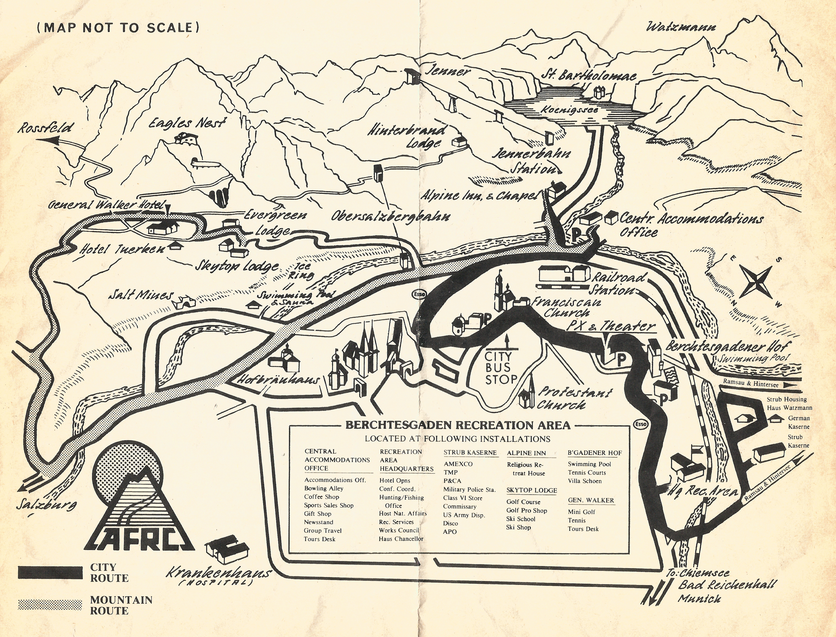
Oh this map brings back wonderful memories!

When Roberta and her brother and sister were cleaning out their mother’s house a few weeks ago they stumbled on this map tucked away into a souvenir booklet of the German region of Berchtesgaden. Their mother picked it up during a visit to Germany in the mid-1980’s when we and Roberta’s brother were stationed in Germany with the US Army.

Bertchesgaden has a twisted history. First let me say that the region, nestled in the southeast corner of Germany right along the border with Austria (the city of Salsburg, made famous in The Sound of Music is just a few miles away) is drop-dead gorgeous, one of the most beautiful places on earth. The high Alpine allure of the Bertchesgaden/Obersalzberg region is undeniable. And that’s why one of history’s biggest monsters, Adolph Hitler, chose to live on the Obersalzberg just above Bertchesgaden. While he was an evil SOB it is undeniable that he had an eye for composition and landscape. In the early 1930’s, using royalties from the sales of his book ‘Mein Kampf’, Hitler bought and started expanding a small gasthaus (hotel) on the Obersalzberg, turning it into his official residence known as the ‘Berghof’ (mountain home). Very quickly the upper echelon of Nazi leadership followed, with Hermann Goering, Heinrich Himmler, Martin Bormann and even Hitler’s personal architect and later minister of armaments Albert Speer establishing residences on the mountain.

During WWII the Obersalzberg was heavily and repeatedly bombed by US and British air forces on the off chance that Hitler or any of his cronies might be at home. They never did kill anyone important but they managed to reduce the buildings on the mountain to rubble. Then the 101st Airborne showed up (a scene made famous in the book and HBO series Band of Brothers) and took over the town and the mountain residences. We gave the town back, but not the mountain. Frankly, the post-war German government didn’t want it back. Too many bad memories. The US Army turned a sow’s ear into a silk purse and converted the entire mountain into a world class recreation center for American service members and their families. Berchtesgaden became one of two premiere Armed Forces Recreation Centers (AFRC) in Germany, the other being Garmisch-Partenkirchen, another former Nazi stronghold and site of the 1936 Winter Olympics,

But Roberta and I especially loved Berchtesgaden and all it offered. While the Garmisch recreation center focused on more intensive sports like skiing and climbing, Berchtesgaden was somewhat sedate and more family focused, perfect for a young couple with a new baby. But what drew me back to the Berchtesgaden AFRC time and again was the history of the place. The main hotel, the General Walker, was a former lodging center for high ranking Nazis and German officers who came to the Obersalzberg to confer with Hitler. When the Nazis owned it they called it the Platterhof, but when we rebuilt it and opened it as a hotel it was named after General Walton Walker, who had recently been killed leading American forces in the early stages of the Korean War.

The main entrance to the General Walker Hotel in the mid-1980’s, as Roberta and I knew it

Roberta on the terrace of the General Walker Hotel, 1984

You could easily stroll from the General Walker to the houses or the ruins of houses of all the key Nazi leadership. The Obersalzberg mountainside was literally littered with Nazi history. The US Army rebuilt some of the structures for their own use, tore down others or just left the ruins in place. On one visit we arrived late to Berchtesgaden to find our room at the General Walker would not be available until the next day, so the hotel management billeted us for the night in what had been Albert Speer’s personal studio, shown in the map above as the Evergreen Lodge. I spent a good part of the night lying awake wondering just what sort of conversations had taken place within those walls as Speer first catered to Hitler’s outlandish architectural dreams and later as the Reich Minister of Armaments he charted the inevitable downfall of the German nation as depicted by the nation’s declining stocks of raw materials and her industrial facilities being pounded to rubble by Allied bombers.

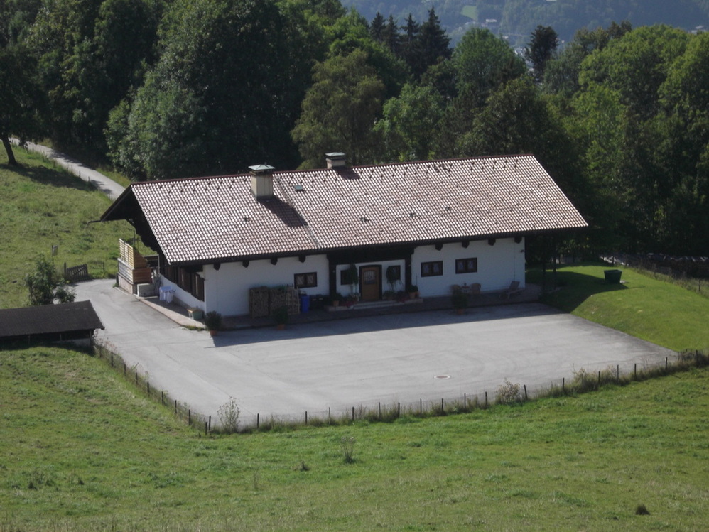
Albert Speer’s design studio, later renamed the Evergreen Lodge by the US and used as VIP lodging on the Obersalzberg. It was located just down the road from the General Walker Hotel

Albert Speer and Hitler conferring over an architectural drawing in Speer’s studio (later the Evergreen Lodge) on the Obersalzberg

But perhaps the most fascinating, and infamous, ruin on the Obersalzberg was Hitler’s official residence, the Berghof. In the early 1950s the US Army blew up the ruins and carted away most of the rubble. However, they didn’t get it all, and some significant remains of the building still stood. While no official US Army map or booklet showed the location of the ruins (note that they are missing from our map above), they were easy to find with just a little research or, in my case, simply by asking the hotel concierge. Immediately below the General Walker terrace (just over Roberta’s shoulder in the picture above) sat the ruins of an old gasthaus known as the Hoher Goll that the Nazis used as an administration office. Just below that, along an abandoned road, sat the remains of Hitler’s Berghof

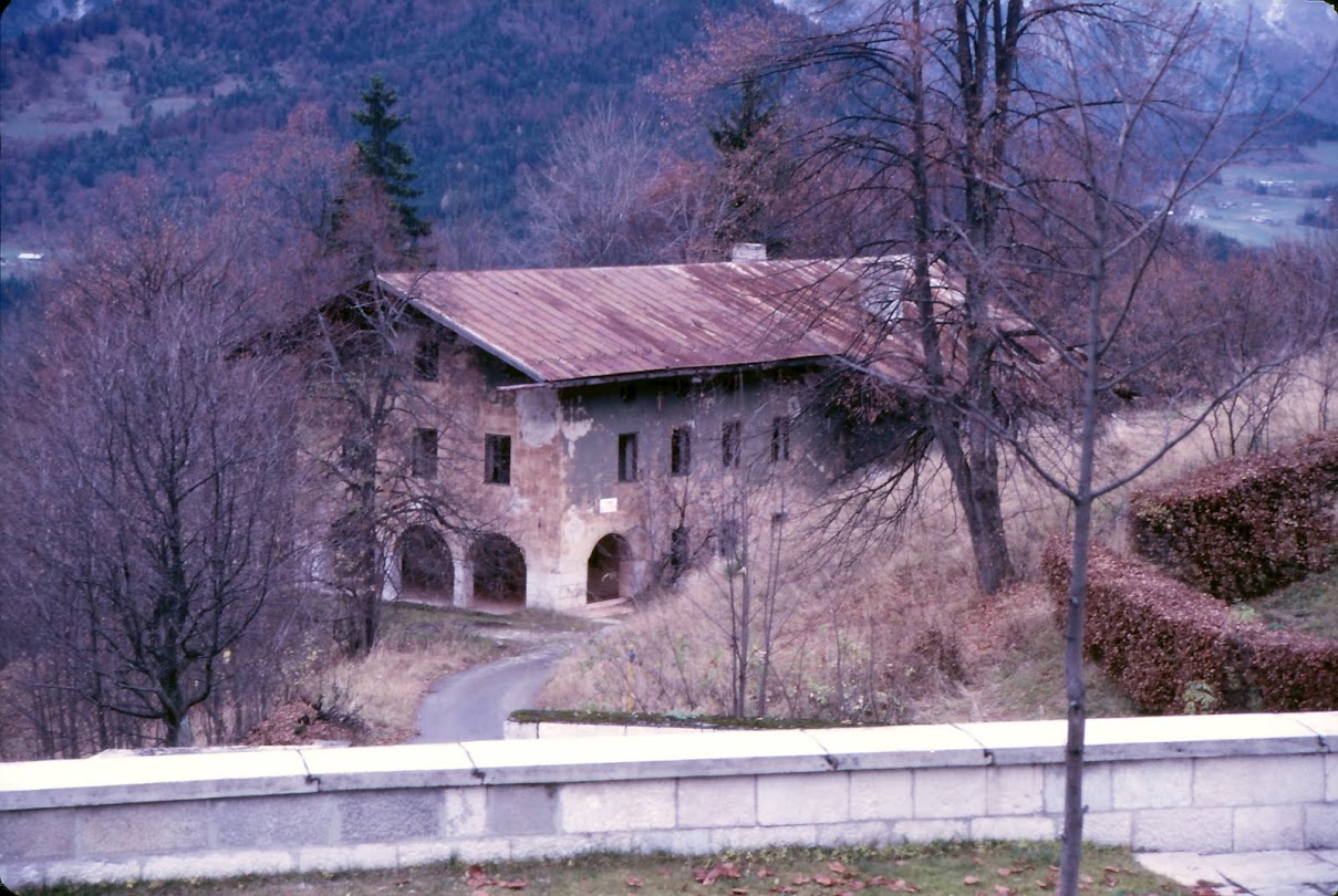
Gasthaus Hoher Goll, used by the Nazis as an administrative office and a guard house controlling access to Hitler’s Berghof. The General Walker terrace wall is in the foreground. I took this picture in 1984

The Gasthaus Hoher Goll when the Nazis owned it, taken from roughly the same perspective as the previous picture. The German soldier at the gate guards access to the Berghof on the road that goes past the Hoher Goll

The Berghof was an expansive villa, more a compound than a house, and it served both as Hitler’s personal residence and a place where he conducted the business of state. Prior to Hitler’s invasion of Poland in 1938 and the opening of WWII, Hitler regularly hosted foreign leaders at the Berghof. Most came away impressed by the building and location but troubled by Hitler’s brand of international diplomacy.

So one afternoon while Roberta was taking a nap I wandered down the road past the ruins of the Hoher Goll and soon found myself looking up at this:

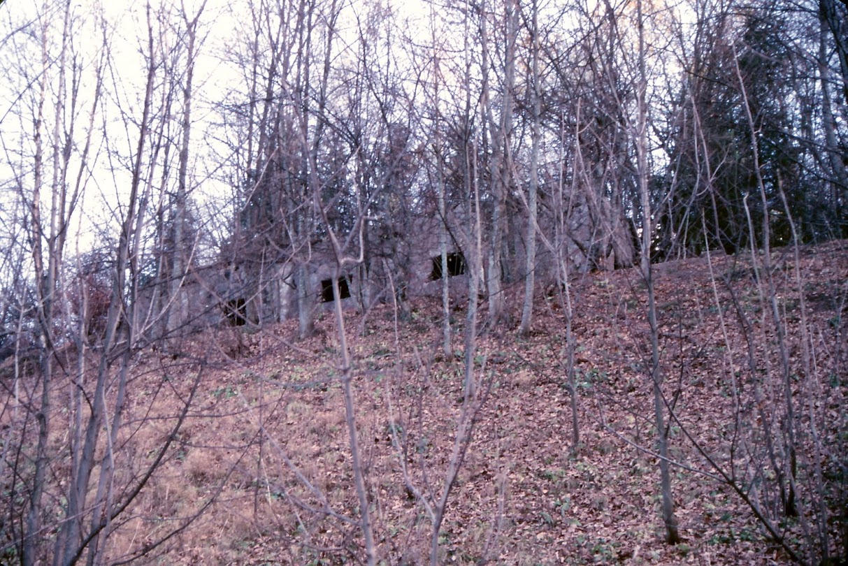
The last standing ruins of Hitler’s Berghof, taken in 1984

All that stood was the remains of the garage on the ground floor of the Berghof, seen in the foreground of this photo:

The garage structure has an interesting history because it supported the outdoor patio that Hitler so loved to sun himself on, and on which so many Nazi luminaries were photographed or filmed

In poking around the ruins I found a piece of brick from the garage that had ‘fallen’ from the wall and ‘accidentally’ made its way into my camera bag. It sits on my mantle today as a unique reminder of a fascinating part of American and German history.

Let’s fast forward a decade or two. In 1995, after the fall of the Soviet Union and troop reductions in Europe the US Army decided to close the Berchtesgaden AFRC and turn the Obersalzberg over to the Germans. We spent millions of dollars getting the facilities ready for the turn over. When we handed the keys to the Germans the facilities were in top-notch condition. Still, the Germans wanted nothing to do with the place and all the buildings stood empty for a few years, including the grand old General Walker. Then one year the Germans ‘forgot’ to winterize the plumbing and steam heat system in the hotel. During a particularly cold winter pipes froze and burst all over the hotel. The Germans declared the hotel uninhabitable, tore it down and turned the location into a parking lot. Fourty years of American memories unceremoniously knocked down and bulldozed away. I still have not forgiven the Germans.

In addition to knocking down the General Walker the German government went after all the remaining ruins on the mountain, to include the last remnants of the Berghof. Any remaining ruins were completely bulldozed and the rubble hauled away. The Germans simply did not want any visible reminders of the Nazi era left on the mountain. The last remnant was the ruins of the old Gasthaus Hoher Goll. It had sat a neglected ruin for over 40 years, but the German government decided to renovate it and turn it into something of a museum that describes just what used to be on the Obersalzberg. Known as the Dokumentation Obersalzberg Museum, it showcases the history of the Obersalzberg from the time when Hitler arrived in the late 1920s to when the Americans left in 1995.

So let’s wrap it up here. There’s a lot more I could talk about in regards to the Obersalzberg, in particular the extensive underground tunnel system the Nazis dug through the mountain to connect all the key residences and facilities. But that’s a topic for another day.

Instead, let me leave you with a link to an excellent video produced by Ruiter Productions in Germany that shows how the Obersalzberg looks today in relation to the 1940s. For old Soldiers and their families who spent time at the Bertchesgaden AFRC it is a nostalgic look back at what was.

– Brian

Terrain Analysis, Soviet Style

Yesterday the folks over at Wired posted a really neat article on the Soviet Union’s military mapping program during the Cold War titled Inside the Secret World of Russia’s Cold War Mapmakers.

Russian Map makers

The author seems to imply that the Russians were better at this sort of thing than the US was. Oh pish-posh. I spent most of my 23 year career in the US Army doing this very same thing – compiling what we called terrain intelligence (now called geospatial intelligence) and placing it onto annotated maps or, more commonly, map overlays. This was GIS long before there was GIS.

But while the former Soviets have done a wholesale dump of their formerly classified terrain intelligence data onto the commercial market to make a few bucks, the US and NATO studies are likely still classified and remain under lock and key.

The Soviets and the US (and our NATO partners like the British and Germans) approached the task in the same way – use every available source, from readily available tourist maps to ‘technical intelligence’ (aka, spy satellites) and on-the-ground observers (aka, spies) to compile extremely detailed map-based studies. In my field we tended to concentrate on factors that would directly impact Army ground operations, things like soil conditions, vegetation types, ground slope, road and bridge capacities, building densities in cities and towns, airport and landing zone data, river and stream conditions and much more.

What made the Soviet’s job so much easier is that the West’s open societies gave them virtually unrestricted access to accurate, detailed mapping data compiled for civilian use. A Soviet military attache assigned to their embassy in Washington DC could simply walk out of his embassy compound and stroll a few blocks to one of several well stocked map stores in the US capital. This included, I’m sure, the excellent map holdings over at the National Geographic Society. The US Geological Survey’s map store was just a short drive away in Reston, VA and I’m sure the Soviet Embassy was one of its best customers.

This military attache’s counterpart in the US Embassy in Moscow couldn’t do the same thing. The Soviets simply didn’t sell or give away maps of their territory. Most mapping data, even the most innocuous, was considered classified. That meant we had to get the data some other way. Of course I’m sure we did our share of bribing, cajoling, blackmailing and stealing to get copies of their maps (remember now, this was a cold war; we weren’t playing patty-cake), but we also very quickly developed out ‘technical intelligence’ capabilities – again, spy satellites – that allowed us to accurately map vast areas of the Soviet Union and her client states from space. It is said that the Defense Mapping Agency was the single biggest consumer of spy satellite imagery during the Cold War.

So dear reader, rest assured that while the Soviets were spying on us to develop highly accurate map and geographic intelligence data we were doing the exact same thing to them. We just haven’t seen the need to sell our intelligence on the open market to make a fast buck.

– Brian

The Old Topographer’s Web Map Gallery

I decided it was time to open my personal ArcGIS Online web map gallery to public scrutiny. This ArcGIS Online site an extension of my Old Topographer/Northing & Easting web environment.

I do a lot of tinkering with web maps using ESRI’s web mapping technology and occasionally I come up with something I think may be useful or interesting to the general public. When I do, those web maps will make their way to this gallery for everybody to try out and comment on.

I also added the gallery as a permanent link (Web Map Gallery) on the links bar at the top of my blog header.

So go have a look, play around, and let me know what  you think! (Just click on the image below)

Old Topographer Website

– Brian

USGS TopoView

It’s rare that I publish blog posts back-to-back, but this new tool from the USGS is so impressive that it deserves to be showcased as soon as possible. I was chasing a link on the USGS site that was provided by a colleague in relation to my blog post yesterday on the Perrysburg Plat Map when I stumbled on a new product titled the USGS TopoView, or ‘topoView’ (note the lowercase ‘t’) depending on where you look on the site. We’ll use the more grammatically correct TopoView.

I’m not sure if this is a replacement for the USGS Historical Topographic Map Explorer released just last year or if it’s a complimentary app. The Historical Topographic Map Explorer seems more suited to map visualization on desktop systems while the TopoView app appears to be more of a data access tool, and one that is designed to run on mobile devices (although I haven’t tested it on a tablet – yet). The site runs slow so I’m guessing they have it running on a development server while they tweak the application, but when it runs well it’s a fascinating way to find, explore and even download USGS products.

I dare say, this is one web application that might just force me to go buy a plotter so I can print out my own full-scale historical map sheets.

So let’s cut to the chase. First watch this video:

Next, go play. Just click the image below to launch TopoView. And don’t blame me if your boss gripes about all the time you are spending on the computer.

USGS TopoView

Have fun!

– Brian

Perrysburg Plat Map

As I’ve mentioned in earlier blog posts, you can find interesting map in the most unusual of places. Earlier this month I was up in northwestern Ohio visiting with my father and decided to take a few hours and check out the local history. I found myself in the delightful town of Perrysburg, right across the Maumee River from my hometown of Maumee. Perrysburg and Maumee ‘grew up’ together during the 1800’s and for much of their history were economic rivals, vying for the lucrative trade that moved up and down the river. In the end both lost out to Toledo, situated a few miles downriver where the Maumee empties into Lake Erie.

Perrysburg became what can best be described as bucolic, a sleepy little town that time and development passed by until one day about 40 years ago folks recognized that the town had a charm and a unique history unsullied by commercial development and tract housing. Suddenly Perrysburg became a trendy place to live and visit. The city worked hard to retain the unique flavor of the historic downtown, and they’ve done a great job.

The town was first established in 1812 on a bluff overlooking the Maumee River. In 1816 two US government General Land Office surveyors, Joseph Wampler and William Brookfield, laid out the town street pattern. Soon after the residents decided to change the town name to Perrysburgh to commemorate Commodore Oliver Hazard Perry’s victory over British naval forces at the Battle of Lake Erie at Put-In-Bay. The ‘h’ was eventually dropped from the Perrysburg town name at some point lost to history.

Perrysburg Plat Map

Wampler and Brookfield appear to be some of the first government surveyors sent into what was known as the Northwest Territory after the War of 1812 to conduct official land surveys using the Public Land Survey System otherwise known as the township & range layout.

The federal government was eager to get this land surveyed, platted and sold. At the time land sales were a major source of revenue for the cash strapped US treasury, plus the government wanted to encourage settlement in the area to solidify American claims to territory ceded by the British and Native Americans under the Treaty of Ghent which ended the War of 1812.

Both Wampler and Brookfield were very competent surveyors and there are records of their work in both the National Archives and the state archives of Indiana, Ohio and Michigan. Wampler is cited by several sources for his efforts in correcting the sloppy work of other surveyors, particularly his work to establish two initial points for the Michigan surveys. Brookfield seems to have headed west from Perrysburg and eventually became a surveyor and later circuit court judge in St. Joseph County, Indiana.

What we don’t know is what induced these two gentlemen to lay out, or plat, the town of Perrysburg. Platting towns and settlements was not something surveyors in the employ of the GLO (General Land Office) did. My guess is that Wampler and Brookfield got specific instructions from the GLO to execute the survey after the town’s leading citizens petitioned their representatives back in Washington, D.C. How rare was it to have GLO surveyors plat a town? Well, there’s only four cities or towns in the United States that were platted by surveyors directly employed by the federal government. Perrysburg is one, Washington D.C., Croghansville (Fremont) Ohio and Shawneetown in the Illinois Territory are the others.

1816 Perrysburg Ohio Plat Map

The notation in the lower right corner indicates that the plat was accepted into the General Land Office records on 18 March 1817 by Josiah Meigs, the Surveyor General of the United States. In 1816 the river was called the Miami River after the Miami Indian Tribe that inhabited the area

The layout and street pattern of Perrysburg as shown in the 1816 plat is still visible today on maps and aerial images. In fact, little has changed. Some lots have been combined, particularly along Louisiana Avenue, which became Perrysburg’s main street and commercial district, and some rail lines and secondary roads have intruded. But for the most part downtown Perrysburg is as Wampler and Brookfield laid it out almost 200 years ago.

To see just how little has changed in the old section of Perrysburg click on the image below to launch a web map that lets you compare 1816 to 2015. Have fun!

Perrysburg Story Map Image JPEG

– Brian

Can Man Live By Chromebook Alone?

Recently I had to make a rushed trip to visit my Dad up in Ohio. I knew I was going to be there at least a week and that I’d have to get some work done. The dilemma I faced was that while Dad is tech savvy all he has available at his house these days is wi-fi and an iPad. Without realizing it, Dad has fully embraced ‘the cloud’. Once he got the iPad figured out he never looked back. It’s stuck to him like an appendage.

Faced with having to take some technology with me I was unsure just what I should bring. I don’t have a personal Windows laptop and the one my employer makes available is so tightly locked down it’s about as useful as a boat anchor in the Sahara. My Galaxy Tab S is a very capable tablet, but it doesn’t offer the kind of screen real estate I felt I’d need to get serious work done.

Thinking about it for a few minutes I realized that most of what I would need to do can be accessed via the web. I conduct just about all of my personal business via a browser interface these days – email, banking, managing my blog sites, etc. About the only thing I turn to a locally installed application for is ESRI’s heavyweight ArcGIS for Desktop environment and Microsoft Office, and if I need to do a remote desktop connection into one of our GIS servers I need to pull up the Windows RDC interface.

At work we are slowly but steadily moving much of our GIS environment to cloud-based services. We are heavy users of ArcGIS Online and are starting to dabble in Amazon Web Services. We are also trying to gently nudge our engineering staff over to some of AutoDesk’s web-based CAD tools like AutoCAD 360 and to web-based document management solutions.

In reviewing my requirements it became apparent that to get work done all I’d need is access to a web browser. The idea of a Chromebook running the Chrome OS (operating system) popped into my head. Actually, the idea had been residing there for some time. I just needed the excuse to go buy one.

Some background:

My wife’s school system moved off of the heavy iron IT model two years ago. They abandoned most of their Windows Server and Microsoft Office environment and moved to Google’s web-based education services environment. Escalating IT costs were putting an unsupportable strain on the school system budget. The move to Google services has been a godsend. Google charges a small annual fee for each account holder in the system (teachers, students and administrators all get their own accounts), they get access to the full suite of Google applications and services and Google manages the environment.

I serve as my wife’s shadow IT support for work related issues. In the old Windows Server/Windows XP/Windows 7 days life was hell. Something was always going wrong and I was always getting calls at work and making trips to her classroom to help troubleshoot hardware and software problems. Roberta is pretty darned tech savvy herself (at one point she served as a Windows NT desktop administrator at her old school in Germany), but she’s a classroom teacher, not an IT tech. She was simply overwhelmed by the number and complexity of the computer issues she faced. She needed to focus on teaching, not troubleshooting a crappy IT environment.

Since the school system moved to Google services the only IT-related trip I’ve had to make to her classroom was to make sure her printer was properly hooked up to her legacy Windows desktop.

The other thing her school has done is scrap the old Windows desktops and laptops in favor of lightweight (and cheap) Chromebooks. At first there was a lot of skepticism about whether a Chromebook could handle the computing needs of the average elementary school student. The school got a grant and bought a small test batch of HP Chromebooks. It turns out the Chromebook experience has been so good that the school is planning to expand it across all grades. The kids have taken to the Chromebooks like ducks to water, there is virtually zero admin overhead. Just open the Chromebook, log in and go! With the State of Georgia’s move to on-line standardized testing the ability to place an inexpensive, easy to use and easy to administer laptop on every student’s desk will become critical over the next few years. Chromebooks seem tailor made to meet that need.

So back to my requirements. It’s clear I’d already been thinking about a Chromebook for my own use, but I had the same concerns my wife’s school had – is the Chromebook capable enough to handle my temporary computing needs? The only way to find out was to take the plunge. The night before I headed up to Ohio I ran out to Best Buy and bought an HP Chromebook 14. This is one of the newer models with the Nvidia Tegra CPU, 2 gb of system memory, 16 gb of RAM and a 14″ HD display. My specific use and test goals included:

  • Overall hardware performance – system speed, storage capacity, wi-fi connectivity, external device connectivity, etc.
  • Managing my organization’s enterprise ArcGIS Online site
  • Managing my email and calendar from my organization’s Exchange server
  • Managing business related Microsoft Office documents
  • Managing my personal business needs – Gmail, my personal Microsoft Office 360 account, banking & finance, this blog, and more
  • Entertainment – watching Nexflix or YouTube videos
  • Stressing the system – can all of this be done with all tabs open at once in a single Chrome browser instance?

So how did it do? Overall I was fairly pleased with the whole Chromebook experience. I very clearly understand the strengths and weaknesses of a browser-based operating system so I didn’t try to do anything that the Chromebook can’t support, like trying to install Adobe Photoshop. The few weaknesses I uncovered were either hardware based or were easy to find work-arounds for. Let’s take a look at some of my observations.

A Chromebook and a wi-fi hotspot (and a cup of coffee) make a great combination for getting some work done in ArcGIS Online

The Good

  • Chrome OS stability is very good. I had just one browser ‘freeze’ early on while I was setting up the system and Chrome was doing an update. Since then there have been no stability issues
  • The Microsoft One Drive and Office apps for Chrome are very well implemented. I’d heard that Microsoft put a lot of time and effort into building out these apps for both the Chrome and Android environments, and it shows. MS Office compatibility was one of my big concerns when going to the Chromebook, but my experience so far has been good. Now, I haven’t tried to open and edit a scientific paper with a lot of special formatting or tried to convert Tolstoy’s War and Peace from Russian to English using the Word translate function,but for the few lightweight documents I’ve created or edited it’s worked just fine
  • While the Chrome Web Store (similar to the Google Play Store for Android) seems to be well stocked with apps, keep in mind that many of these ‘apps’ are little more than shortcuts to web versions of certain products. I was pleased to find Microsoft Office and OneDrive apps – Word, Excel & PowerPoint that can tie directly back into my Microsoft Office 365 account.. Sorry, no Access. Skype seems to have been integrated into the Outlook app, but since I don’t use Outlook for personal business I didn’t get  a chance to test it.
  • ArcGIS Online management. I was pleased to find that managing my enterprise and personal ArcGIS Online environments was as easy on the Chromebook as it is sitting behind my GIS worstation back in the office. With one very minor exception – the uploading of thumbnail images to GIS service properties pages – the ArcGIS Online management experience is the same on this inexpensive Chromebook as it is on a $4,000 top-of-the-line desktop workstation
  • Video performance is first rate. Videos from YouTube and Netflix played smoothly with no dropped frames of audio issues

You may wonder why all the emphasis on Microsoft Office in the above comments. The reason is simple. While Google thinks its Google Docs suite will conquer the world the truth is that most of corporate America is still tightly wedded to Microsoft Office. For a Chromebook to be considered a serious replacement for a corporate laptop it must provide robust Microsoft Office compatibility.

Ohio River Town

What can you do in ArcGIS Online with a Chromebook? Build a Story Map! While in Ohio I visited some old favorite locations and built out this web map using ESRI’s Story Map template. The Chrome OS handles the ArcGIS Online interface just fine. You can click on the image to launch the map

The Not-So-Good

Most of the negative issues seem to be closely related to the HP hardware and it’s impact on the Chrome OS performance. Let’s have a look:

  • 2 gb of system memory is not enough. When more than four browser tabs are open performance starts to suffer. Even worse, there are some apps (Norton, the Ad Block app and others) that when installed will run in the background on every tab. These background apps absolutely kill system performance. My recommendation is to simply not add any of these to your Chromebook, but the long term solution is a Chromebook with more system memory. The next one I buy will have at least 4 gb of system memory
  • Why no delete key? Chromebooks don’t have Delete keys. Really? Like I never make mistakes and have to delete anything
  • Overall system performance is highly dependent on the quality and speed of your wi-fi connection. A lousy internet connection = a lousy Chromebook experience. Google touts that some Chrome OS features like Google Docs can be used off-line. My limited experience tells me that this an iffy proposition that highlights another hardware shortcoming…
  • 16 gb of RAM is too paltry. The system files take up almost half of that right off the top, leaving a pitiful 8 gb to store all of your off-line treasures. This situation can be mitigated somewhat by using a MicroSD memory card, assuming your Chromebook accepts one. The real answer is for manufacturers to bump up the system RAM to 32 gb

Neutral Observations

These are neither good points or bad points, just observations on software and hardware performance:

  • HP build quality is very good. Although the construction is all plastic the deice is sturdy and well put together. Battery life is also very good, offering slightly over 6 hours of continuous use
  • When the Chromebook is closed (but not shut off) battery drain appears to be reduced to near zero. It’s amazing that I can close this thing while it is still running and come back days later and there’s been almost zero battery drain
  • If the Chrome OS is secure from viruses and malware, as Google claims, why does Norton offer a Chrome-specific protection package?
  • No Google Earth. This highlights the key limitation of the Chrome OS. You can’t run installed applications on a Chromebook. As I mentioned above, the ‘apps’ you add to your Chromebook via the Chrome Web Store are little more than shortcuts to web sites that are highly configured to run in Chrome OS. You can’t install a stand-alone application in Chrome. Since Google Earth requires a ‘client side’ install this means no Google Earth on Chromebooks. So even Google can’t give you access to everything they offer
  • You can’t park icons or shortcuts on the ‘desktop’ because the ‘desktop’ isn’t really a ‘desktop’. It is just a holding space for the browser window to occupy. Old time Windows users will find this very frustrating. You can park shortcuts and icons on the taskbar at the bottom of the screen, but the rest of the ‘desktop’ is merely a vast, open and unused space until you open a Chrome browser
  • With the maturation of HTML5 and Java developers are pushing more and more functionality into the web browser, which places more demand on the ‘client side’ hardware. I wonder just how well Chrome OS will perform in the future, particularly on limited hardware, as developers bring more and more processing complexity into the browser technology
  • Personally I find this 14 inch Chromebook too big. Don’t get me wrong – it works great, but as a ‘grab ‘n go’ laptop it’s just too large. I’m keeping my eyes out for a 11 or 12 inch model with the right combination of processing power and battery life

So is the Chromebook a viable substitute for a full-up laptop? No. If you need to run installed applications (like ArcGIS for Desktop, or Adobe Photoshop, or even Google’s own Google Earth) or  then you will need to stick with Windows or MacOS. However, when working within the well understood limitations of the Chrome OS environment I found the experience pretty darned good. Let’s just say I’m a fan. In fact I’m already thinking about my next Chromebook purchase. A nice robust 12″ model with a fast processor, 4 gb of system memory and 32 gb of RAM and 8 hours of battery life. Price it under $300 and I’ll be in line to buy one!

– Brian

Be Sure To Get Some Insurance Before Your Next Flight To Eniwetok

Those were the days. Piston driven airplane engines, unpressurized cabins, in flight food service that consisted of a box lunch tossed at you by a loadmaster, and your luggage not just flying on the same plane, but often flying right next to you on a pallet lashed to the bare aircraft floor. Aaaah, to be a serviceman in the 1960’s headed of for exotic ports of call like Johnston Island, Keflavik, Tripoli or Karachi.  All courtesy of the US Air Force’s Military Air Transport Service and the US Air Force Europe’s 322nd Air Division.

But hey Soldier, before you board that plane why not get yourself some flight insurance? Who knows when that engine was last overhauled or the hydraulic fluid levels were checked? The responsible thing is to leave Mom & Dad a little pocket money should the unexpected happen. So step over to the Mutual of Omaha insurance desk right here in the MATS terminal and sign up for a few hundred dollars, or even a few thousand dollars of flight insurance. It’ll give you peace of mind and maybe even help the folks pay for that new Oldsmobile they’ve been seeing in the commercials on the Ed Sullivan Show.

Flight Insurance

After WWII the US Air Force recognized the need to maintain the ability to transport personnel to make sure they could get the people and supplies where they were needed, often to places commercial airlines couldn’t or wouldn’t fly. This led to the creation of the Military Air Transport Service (MATS). While MATS operations were severely restricted inside the United States (the commercial airlines didn’t like the idea of competing with Uncle Sam), the Air Force operated regularly scheduled personnel and logistics flights to a wide variety of duty posts as far flung as Thule, Greenland and Dhahran, Saudi Arabia.

The map on this post card neatly reflects the state of our military commitments in the late 1950’s and early 1960’s. At the time we had a heavy presence in Europe, North Africa and the Middle East. We tied the Pacific basin together with bases on Johnston Island, the Marshall Islands, Iwo Jima, Manila and Saigon. One of the goals of all this activity was to let the Soviets know, in clear terms, that we could move what we wanted, when we wanted, to where we wanted. At the time we were a true global power and everyone knew it.

But back to our poor Soldier about to climb aboard that rickety C-54 transport and fly a thousand miles at night to a small spot in the middle of the Atlantic known as the Azores. Suddenly buying a few hundred bucks worth of flight insurance doesn’t seem like such a bad idea. After all, you just never know. Good thing Mutual of Omaha is johnny on the spot with an insurance counter where you fill out your form, slip it and some cash into an envelope and drop it into the collections slot, hoping like hell your folks never see a return on the investment.

I’m not sure when this postcard was printed, but I’m guessing the late 1950’s or early 1960’s based on the flights into France (Charles de Gaulle kicked us out in 1967) and the fact that the Military Air Transport Service became the Military Airlift Command in 1966. The back of the card shows no marking to indicate the date of printing, but it does helpfully remind us that insurance is available at all MATS or ALS terminals. Just in case our Soldier wants more insurance for the second leg of his trip.

Flight Insurance 2

Flight insurance was a common offering in airport terminals in those days. As a kid I remember seeing the insurance counters during our infrequent trips to the airport to pick up visiting relatives or say goodbye on those rare occasions when one of our family members flew. Flying was frightfully expensive in those days, and the insurance counters served as a reminder that flight was still something a bit daring and risky.

– Brian

You Can Find Maps Anywhere!

Tonight I attended a public hearing on a Georgia Department of Transportation initiative that impacts some roads in my county. The hearing was held in a local church and as I walked out of the assembly hall I was struck by a familiar and friendly sight.

This is a wall-size map of the world produced by the old Defense Mapping Agency (DMA). The map was printed in several panels and was available for US military units to order through the local installation map warehouse or directly from DMA. The best part was, like all DMA products (maps, charts, catalogs and publications) these maps were free to the military. Order one or a hundred, it didn’t matter!

These maps adorned US military headquarters all over the world, from Korea to Germany. They hung in briefing rooms and hallways all over the Washington DC area. You couldn’t claim to have a serious operations center without at least one of these hanging on a wall somewhere.

The church apparently uses the map to track where their parishioners are from and where their missionary efforts are taking place. A wonderful use for an old war horse of a map.

It was good to see an old friend again.

– Brian

The Vanished Town of Glastenbury and The Bennington Triangle

Let’s showcase someone else’s work for a change. Chad spins a wonderful yarn about New England history as depicted in the life, and death of the small villages and settlements that used to cling tenuously to the wooded slopes of Vermont. Cartography and the sense of place help tie everything together, and this is as much a story of the land as it is the story of it’s inhabitants. Enjoy

Obscure Vermont

Those who know me know that I’m a huge cartography buff. That love really perpetuated when I was 10, when my mother bought me a DeLorme atlas of Vermont, and I became enthralled with it, thoroughly memorizing every detail I could. But what is it about maps that are so irresistible to me?

Maybe because of their limitless potential, and their ability to unlock the mysteries of our world. Maps tell us how things in this world relate to one another, they take data and turn it into something tangible, something understandable, and maybe something that provokes thought or feelings. Several different types of information can be conveyed at the same time, melding several different ideas into a united idea. Lines to convey topography, more lines to convey boundaries between rock layers, towns, states and countries. More lines for faults, colors for bodies of water, forest land and types of climates. Maybe it’s…

View original post 6,510 more words